Method for picking longitude and latitude information from planning map

A technology of latitude and longitude information and maps, applied in the field of unstructured data conversion, can solve the problem of not realizing the value of data

Inactive Publication Date: 2019-11-26
柴日发 +1
View PDF2 Cites 2 Cited by
  • Summary
  • Abstract
  • Description
  • Claims
  • Application Information

AI Technical Summary

Problems solved by technology

However, for a long time, people have not realized the value of these data or there is no good solution to extract structured data from unstructured pictures, thus turning a blind eye to these free big data golden treasures on the Internet

Method used


Image

  • Method for picking longitude and latitude information from planning map
  • Method for picking longitude and latitude information from planning map
  • Method for picking longitude and latitude information from planning map

Examples


Embodiment Construction

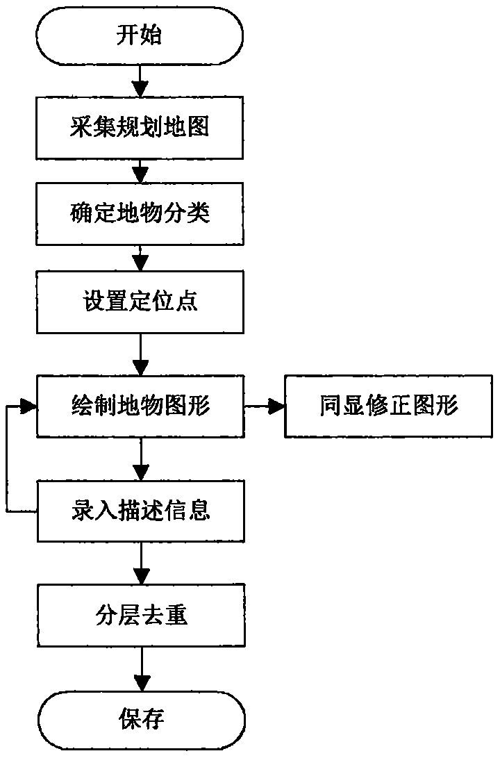
[0040] The present invention is mainly composed of a planning map collection system, a planning map graphic picking system, and a planning map feature information storage system. These three systems are software systems set according to functions, and can be connected by three servers through the Internet or intranet. These servers can be servers or cloud servers of various brands and configurations, and the corresponding operating systems can be a variety of options, such as Windows, Linux, Solaris, etc.

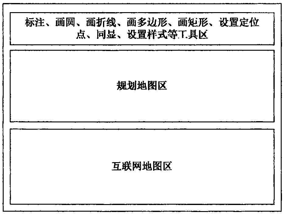
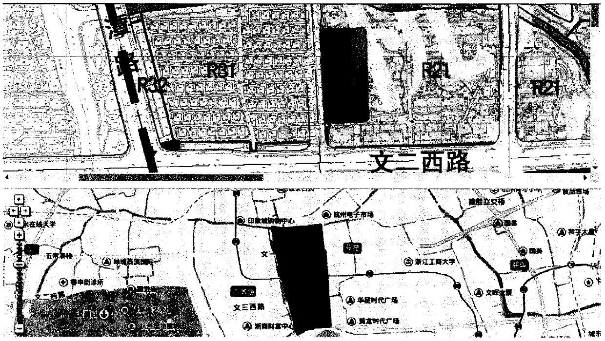
[0041] The core of which is the planning map graphical picking system, which adopts the BS development plan and uses JavaScript language to develop. The most critical of these is the realization of planning map graphics drawing technology. There are many options for technical solutions such as SVG technology, DIV technology or H5 Canvas technology. Usually, the path element of SVG is selected for implementation, because the graphics on Internet maps are generally also Use ...


PUM


Abstract

The invention relates to a method for picking up longitude and latitude information and description information of a ground object from a publicly published scattered planning map picture. The basic principle of the method is that on the urban scale, it is assumed that all planning maps are Mercator projection type maps and are strictly managed by planning departments, so that the standard spatialgeographical relationship is kept, and therefore the conversion algorithm of planning place pixel coordinates, Internet map Mercator coordinates and geodetic longitude and latitude coordinates is determined. The method comprises the following basic steps: 1, establishing a proportional relation between planning place image pixel coordinates and Internet map Mercator coordinates through positioning points; 2, drawing on a planning map by using tools such as a marking tool, a circle drawing tool, a multi-fold line tool, a multi-square tool and a rectangle tool; 3, drawing a corresponding graphon an Internet map through a simultaneous display function so as to visually assist information pickup; 4, inputting corresponding description information into a drawing graph of the planning map; and5, carrying out layering and duplicate removal on the surface feature longitude and latitude and description information obtained through graphical assistance, and then storing the information in anurban planning database.

Description

Technical field: [0001] The present invention relates to the field of unstructured data conversion, and is a method of picking up valuable planning features latitude and longitude information and description information from planned map pictures publicly released by the government, so as to realize structured data storage and conversion of unstructured map pictures. Methods of Commercial Exploitation. Background technique: [0002] Big data service is a development hotspot in the development of the Internet in recent years. To do big data service, we must first determine the source of big data, collect, clean and store it, and then extract valuable data through various data mining algorithms and innovate applications. I found that the planning map webpage data published on the Internet every day is a good source of big data, but like tritium in the sea, people have not yet found an efficient way to develop it. [0003] The planning map is a practical thematic map used to re...

Claims


Application Information

Patent Timeline
Patent Type & Authority Applications(China)
IPC IPC(8): G06F16/29G06Q50/26
CPCG06F16/29G06Q50/26
Inventor 柴日发柴溢洲
Owner 柴日发
Why Eureka
Try Eureka