Supercharge Your Innovation With Domain-Expert AI Agents!

Remote sensing image semantic segmentation method and device fusing edge detection

An edge detection and semantic segmentation technology, which is applied in the field of surveying and mapping remote sensing/image processing, can solve the problem of inaccurate segmentation object edges, etc., and achieve the effect of reducing object boundary confusion, accurate edges, and reducing accuracy dependence

Pending Publication Date: 2019-12-13
武汉珈和科技有限公司
View PDF3 Cites 4 Cited by
  • Summary
  • Abstract
  • Description
  • Claims
  • Application Information

AI Technical Summary

Problems solved by technology

[0004] Aiming at the inaccurate edge segmentation problem of the existing remote sensing image depth semantic segmentation algorithm, the present invention proposes a remote sensing image depth semantic segmentation method and device that incorporates an edge detection algorithm, which significantly improves the edge accuracy of the segmented object

Method used


Image

  • Remote sensing image semantic segmentation method and device fusing edge detection
  • Remote sensing image semantic segmentation method and device fusing edge detection
  • Remote sensing image semantic segmentation method and device fusing edge detection

Examples


Embodiment Construction

[0045]In order to make the purpose, features and advantages of the present invention more obvious and understandable, the technical solutions in the embodiments of the present invention will be clearly and completely described below in conjunction with the accompanying drawings in the embodiments of the present invention. Obviously, the following The described embodiments are only some, not all, embodiments of the present invention. Based on the embodiments of the present invention, all other embodiments obtained by persons of ordinary skill in the art without making creative efforts belong to the protection scope of the present invention.

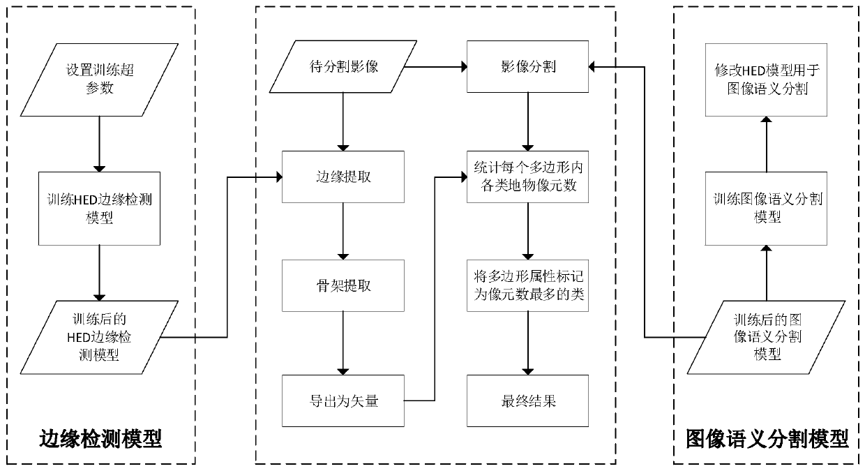
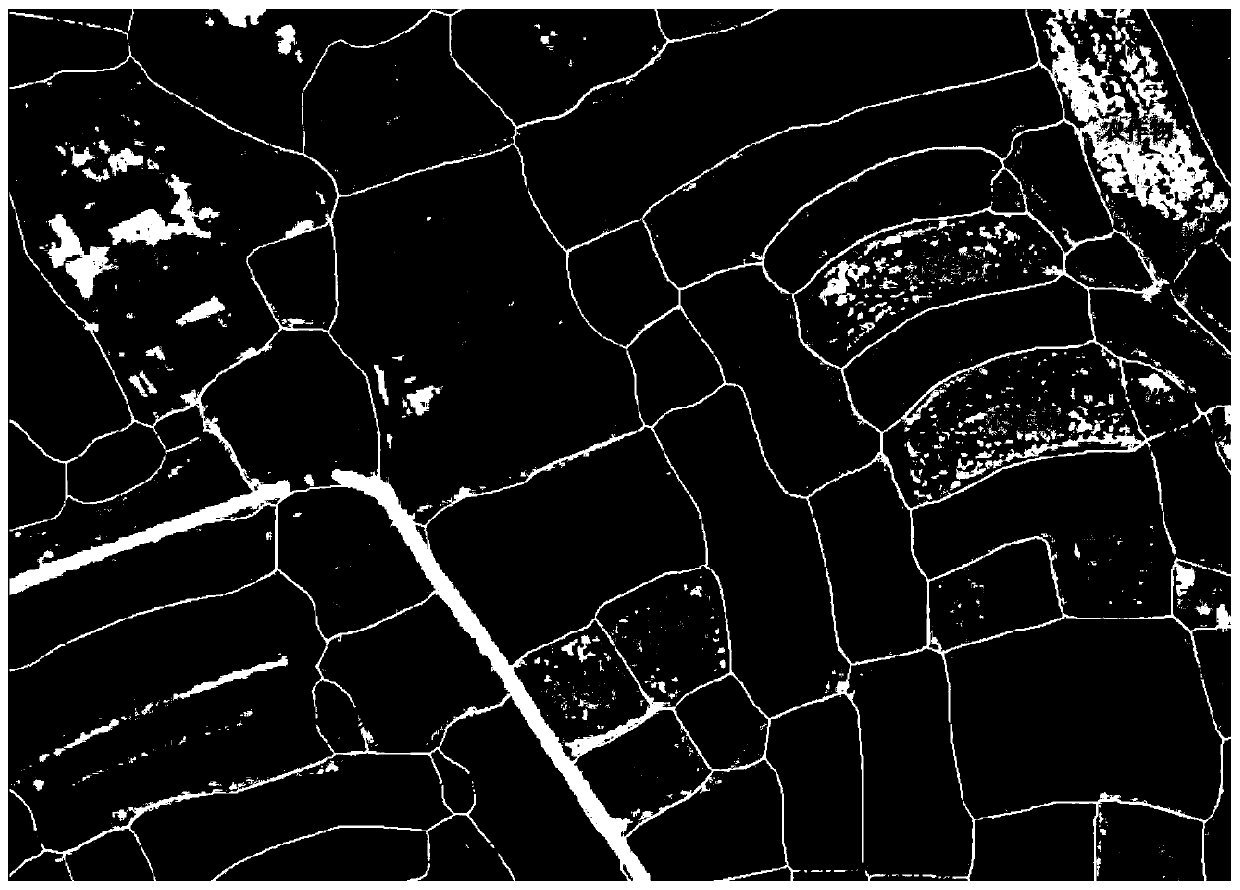
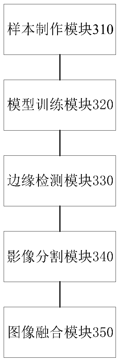
[0046] see figure 1 , the present invention proposes a remote sensing image semantic segmentation method that combines edge detection, uses high-resolution remote sensing images marked with object types to make training samples, trains edge detection models and image segmentation models respectively, and treats segmented remote sensing ima...


PUM


Abstract

The invention provides a remote sensing image semantic segmentation method and device fusing edge detection. The method comprises the steps of manufacturing a training sample according to a high-resolution remote sensing image; respectively training an HED edge detection model and an image semantic segmentation model; performing edge detection on the remote sensing image to be segmented by using the trained HED edge detection model to generate an edge probability graph, and performing post-processing on the edge probability graph; performing image segmentation on the remote sensing image to besegmented by using a trained image semantic segmentation model; and superposing the result of the edge detection post-processing and the image after image segmentation based on a geographic positionto obtain a semantic segmentation vector result of the remote sensing image to be segmented. According to the method, the edge detection model is combined, so that the edge of the segmentation objectis more accurate, the precision dependence on the semantic segmentation model is reduced, the complexity of the large-scale image semantic segmentation model is greatly reduced, and the model has expansibility.

Description

technical field [0001] The invention belongs to the field of surveying and mapping remote sensing / image processing, and in particular relates to a remote sensing image semantic segmentation method and device with fusion edge detection. Background technique [0002] With the increasing amount of high-resolution remote sensing satellite resources and data, the ground object information obtained by remote sensing is becoming more and more refined, and it also brings greater challenges to image interpretation technology. Remote sensing image segmentation is an automatic or semi-automatic remote sensing image interpretation method, which can mark remote sensing image pixels into objects with semantic concepts. It is currently more and more widely used in remote sensing image analysis. Common remote sensing commercial software such as ENVI, Erdas, and PCI have integrated remote sensing image segmentation algorithms, and there are also powerful professional remote sensing image seg...

Claims


Application Information

Patent Timeline
IPC IPC(8): G06T7/10G06T7/13
CPCG06T7/10G06T7/13G06T2207/10032G06T2207/20081G06T2207/20128
Inventor 王艳杰杨泽宇冷伟
Owner 武汉珈和科技有限公司
Features
  • R&D
  • Intellectual Property
  • Life Sciences
  • Materials
  • Tech Scout
  • Unparalleled Data Quality
  • Higher Quality Content
  • 60% Fewer Hallucinations
Learn More