Check patentability & draft patents in minutes with Patsnap Eureka AI!

Methods for geospatial positioning and portable positioning devices thereof

A positioning device, geospatial technology, applied in positioning, satellite radio beacon positioning system, photo interpretation and other directions, can solve problems such as time-consuming and inaccuracy

Pending Publication Date: 2020-01-31
TRIMBLE NANTES
View PDF0 Cites 2 Cited by
  • Summary
  • Abstract
  • Description
  • Claims
  • Application Information

AI Technical Summary

Problems solved by technology

However, leveling the pole can be time consuming and / or imprecise

Method used


Image

  • Methods for geospatial positioning and portable positioning devices thereof
  • Methods for geospatial positioning and portable positioning devices thereof
  • Methods for geospatial positioning and portable positioning devices thereof

Examples


Embodiment Construction

[0099] Exemplary embodiments now will be described more fully hereinafter with reference to the accompanying drawings, in which presently preferred embodiments are shown. However, this invention may be embodied in many different forms and should not be construed as limited to the embodiments set forth herein; rather, these embodiments are provided for thoroughness and completeness, and to fully provide the skilled convey the scope of the invention.

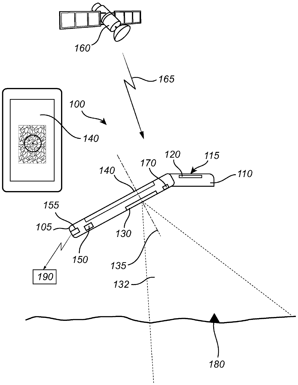
[0100] refer to figure 1 , describes a portable positioning device 100 according to some embodiments of the present disclosure.

[0101] figure 1 A portable positioning device 100 is shown comprising: a GNSS receiving unit 110 including an antenna 120, an imaging device 130, a display unit 140, an inertial measurement unit IMU or multiple gyroscopes and accelerometers 170, a processor / processing unit or data collector 150, and the transmitter 155.

[0102] figure 1Also shown is a data fusion processor 190 in communication wit...


PUM


Abstract

Embodiments provide for a method of determining a geospatial position of a point of interest (180) and a portable positioning device (100) thereof. In one embodiment, the method includes collecting data from a GNSS receiving unit (110) and data from at least one of an imaging device (130) and an inertial measurement unit (170), IMU, of the positioning device for a plurality of positions of the positioning device in the vicinity of the point of interest. The collected data is then transmitted to a data fusing processor (190) for determining orientations and positions of the positioning device for the plurality of positions in a global coordinate system. Further, the method includes obtaining a pointing input indicative of a position of the point of interest relative to the positioning device for at least one reference position of the positioning device. The pointing input is transmitted to the data fusing processor for identifying the point of interest and for determining the geospatialposition of the point of interest in the global coordinate system based on the determined orientations and positions of the positioning device in the global coordinate system.

Description

technical field [0001] The present disclosure relates generally to the field of positioning, and more particularly to methods for geospatial positioning and portable positioning devices adapted to obtain the geospatial location of a point of interest. The methods and positioning devices disclosed herein can provide three-dimensional geospatial locations of points of interest. Background technique [0002] Positioning involves the technique of determining the position of a person, object, or system on or near the surface of the Earth, that is, the technique of determining the coordinates (latitude, longitude, and altitude) of a place. Positioning may be of interest, for example, in the field of surveying techniques where the purpose is eg point-based determination of land positions or three-dimensional positions, using relative distances and angles between these points to build land maps. In such applications, the resulting land map will depend on the survey system, componen...

Claims


Application Information

Patent Timeline
IPC IPC(8): G01S19/48G01S19/49G01S19/10
CPCG01S19/49G01S19/10G01S19/485G01C21/1656G01C11/06G01S19/14G01C15/00G01S5/0027G01S19/47G06V20/20G06F18/25
Inventor 查尔斯·莱美尔
Owner TRIMBLE NANTES
Features
  • R&D
  • Intellectual Property
  • Life Sciences
  • Materials
  • Tech Scout
  • Unparalleled Data Quality
  • Higher Quality Content
  • 60% Fewer Hallucinations
Learn More