Soil information extraction method and device for unmanned aerial vehicle visible light image

A technology of soil information and extraction method is applied in the field of soil information extraction for UAV visible light images, which can solve the problem of inability to extract soil information by soil index.

Active Publication Date: 2020-01-31
YUNNAN NORMAL UNIV
View PDF2 Cites 2 Cited by
  • Summary
  • Abstract
  • Description
  • Claims
  • Application Information

AI Technical Summary

Problems solved by technology

[0004] However, since the UAV visible light image only has three bands of R, G, and B, it is impossible to use the soil index in the above formula to extract soil information

Method used


Image

  • Soil information extraction method and device for unmanned aerial vehicle visible light image
  • Soil information extraction method and device for unmanned aerial vehicle visible light image
  • Soil information extraction method and device for unmanned aerial vehicle visible light image

Examples


Embodiment Construction

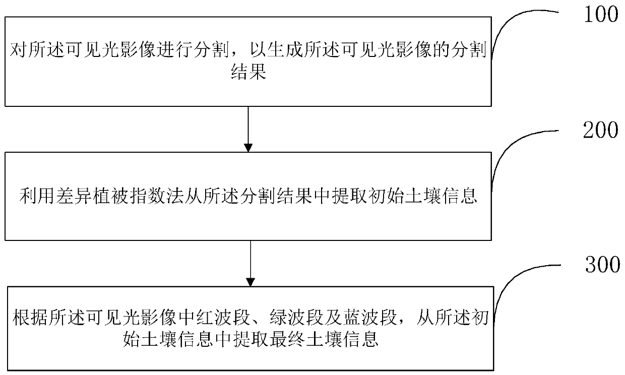
[0054]In order to make the purpose, technical solutions and advantages of the embodiments of the present invention clearer, the technical solutions in the embodiments of the present invention will be clearly and completely described below in conjunction with the drawings in the embodiments of the present invention. Obviously, the described embodiments It is a part of embodiments of the present invention, but not all embodiments. Based on the embodiments of the present invention, all other embodiments obtained by persons of ordinary skill in the art without creative efforts fall within the protection scope of the present invention.

[0055] In view of the lack of information in the visible light band of UAVs in the prior art, it is impossible to use the traditional index method to extract soil information. Based on this, an embodiment of the present invention provides a specific implementation of a soil information extraction method for UAV visible light images, see figure 1 ,...


PUM


Abstract

The invention provides a soil information extraction method and device for an unmanned aerial vehicle visible light image, and the method comprises the steps: carrying out the segmentation of the visible light image, so as to generate a segmentation result of the visible light image; extracting initial soil information from the segmentation result by using a differential vegetation index method; and extracting final soil information from the initial soil information according to the red band, the green band and the blue band in the visible light image. According to the unmanned aerial vehiclevisible light image-oriented soil information extraction method and device provided by the invention, in the unmanned aerial vehicle visible light image, soil information and other information in theunmanned aerial vehicle visible light image can be distinguished only by utilizing three wave bands R, G and B in the visible light image, so that the soil information is accurately extracted.

Description

technical field [0001] The present invention relates to the technical field of remote sensing image interpretation, in particular to the technical field of UAV visible light image ground feature information interpretation, and in particular to a soil information extraction method and device for UAV visible light image. Background technique [0002] UAV visible light images have the advantages of high definition and large scale. However, most UAV visible light images only have three bands of red (R), green (G), and blue (B), and UAV images containing only three bands of RGB are called visible light images. Compared with multi-band satellite remote sensing images (such as Landsat 8OLI), UAV visible light images have higher spatial resolution, but have less band information, and traditional index methods cannot be used to extract soil information. Early scholars used the Normalized Difference Soil Index (NDSI) to extract soil information (Formula 1). In formula (1), MIR repre...

Claims


Application Information

Patent Timeline
Patent Type & Authority Applications(China)
IPC IPC(8): G06K9/00G06K9/46
CPCG06V20/13G06V10/44G06V10/56
Inventor 段平李佳李晨成李博王云川
Owner YUNNAN NORMAL UNIV
Why Eureka
Try Eureka