A vehicle platoon building map and its adaptive following distance calculation method

A vehicle-to-vehicle self-adaptive technology, applied to vehicle components, vehicle-to-vehicle communication, vehicle wireless communication services, etc., can solve the problems of limited queue flexibility, large errors, and excessive size

Active Publication Date: 2020-09-11
CENT SOUTH UNIV
View PDF11 Cites 2 Cited by
  • Summary
  • Abstract
  • Description
  • Claims
  • Application Information

AI Technical Summary

Problems solved by technology

However, in actual scenarios, there are still the following problems that restrict the application of vehicle platoon cooperative control
[0003] (1) The vehicle platoon feature map creation method applied to engineering is a prerequisite for realizing the vehicle platoon cooperative control, however, there is no public vehicle platoon mapping method;
[0004] (2) The traditional calculation method of the actual following distance has a large error in the curve driving scene
The on-board perception sensor will have perception blind spots, and what the sensor acquires is the straight-line distance between the two vehicles, which deviates from the actual following distance in the curve scene; the odometer will have cumulative errors, and when the vehicle leaves the queue, due to The accumulated vehicle displacement is not on the expected path, and the vehicle cannot return to the queue, which limits the flexibility of the queue;
[0005] (3) The traditional strategy of expected following distance cannot take into account the safety of vehicle platoons and traffic flow density
At present, the most commonly used following distance strategy is the constant time distance strategy d i (t)=l+h*v i with constant distance strategy d i (t)=l, however, these two strategies have certain defects in practical application
Constant time distance strategy and vehicle speed v i Proportional to, when the vehicle speed is high, the following distance d i (t) will be too large, limiting the traffic flow density
The constant distance strategy fixes the following distance to a fixed value. In the high-speed following state, if the front car brakes, the rear car may not be able to respond in time, and there may be a risk of collision

Method used


Image

  • A vehicle platoon building map and its adaptive following distance calculation method
  • A vehicle platoon building map and its adaptive following distance calculation method
  • A vehicle platoon building map and its adaptive following distance calculation method

Examples


Embodiment Construction

[0107] The following is a detailed description of the embodiments of the present invention. This embodiment is carried out based on the technical solution of the present invention, and provides detailed implementation methods and specific operation processes to further explain the technical solution of the present invention.

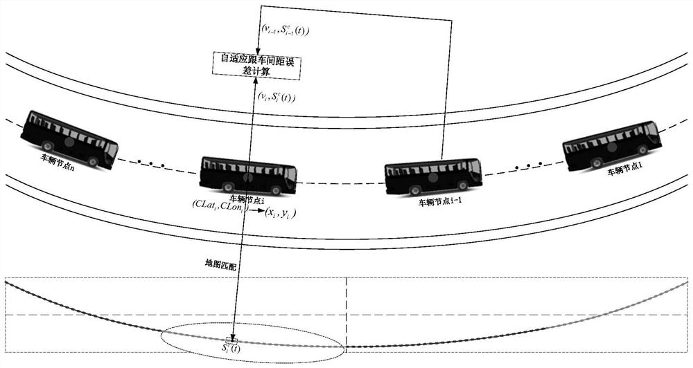
[0108] An embodiment of the present invention provides a vehicle platoon building map and its adaptive following distance calculation method, such as figure 1 shown. Include the following steps:

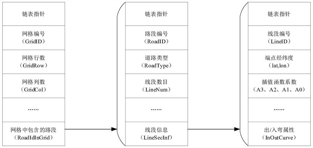
[0109] Step 1: The map collection vehicle equipped with integrated inertial navigation collects GPS points on the driving path of the vehicle queue, and makes a characteristic map according to the following process:

[0110] Step 1: The map collection vehicle equipped with integrated inertial navigation collects the latitude and longitude (lat k ,lon k ), altitude hei k , heading angle yaw k , the subscript k indicates the kth GPS point recorded, generally...


PUM


Abstract

The invention discloses a vehicle queue mapping method and a calculation method thereof for an adaptive distance to a following vehicle. The vehicle queue mapping method comprises the following steps:acquiring GPS points on a travel path of a vehicle queue by a map acquisition vehicle, and constructing a characteristic map; numbering each vehicle in the vehicle queue from 1 to n; and enabling each vehicle in the vehicle queue to execute the operations of acquiring own location and speed information, finding the nearest point on the characteristic map according to the own location information,taking displacement of the point in the characteristic map as own displacement, wirelessly sending own number, displacement and speed information to the other vehicles, defining an expected adaptivedistance to the following vehicle according to the own number and speed as well as the received numbers and speeds of the other vehicles and then calculating an error of the distance to the followingvehicle by combining the own displacement and the received displacements of the other vehicles. The vehicle queue mapping method disclosed by the invention can improve accuracy of collaborative calculation of the distance to the following vehicle as well as flexibility of the vehicle queue and gives consideration to traffic flow density and safety of the following vehicle.

Description

technical field [0001] The invention relates to the field of vehicle platoon cooperative control, in particular to a vehicle platoon building map and an adaptive following distance calculation method thereof. Background technique [0002] Vehicle platoon cooperative control is one of the important contents of future unmanned system research. Realizing vehicle platoon driving can increase the potential capacity of the road and reduce air resistance, which has important application value for alleviating traffic pressure and reducing energy consumption. To realize the coordinated control of vehicle platoons, it is first necessary to map the driving path and obtain accurate distance information between vehicles. However, in practical scenarios, the following problems still restrict the application of vehicle platoon cooperative control. [0003] (1) The vehicle platoon feature map creation method applied to engineering is a prerequisite for realizing the vehicle platoon coopera...

Claims


Application Information

Patent Timeline
Patent Type & Authority Patents(China)
IPC IPC(8): G08G1/00G08G1/16H04W4/40H04W4/46
CPCG08G1/161G08G1/166G08G1/20G08G1/205H04W4/40H04W4/46
Inventor 余伶俐况宗旭王正久周开军白宇霍淑欣
Owner CENT SOUTH UNIV
Why Eureka
Try Eureka