Surveying and mapping device for engineering based on unmanned aerial vehicle

A surveying and mapping device, unmanned aerial vehicle technology, applied to unmanned aerial vehicles, motor vehicles, aircraft parts, etc., can solve the problems of damage to the surveying and mapping camera, complicated adjustment, insufficient protection performance of the surveying and mapping camera, etc., to prevent excessive lifting and ensure Use safe effects

Inactive Publication Date: 2020-02-28
江苏盐西土地整理开发有限公司
View PDF9 Cites 6 Cited by
  • Summary
  • Abstract
  • Description
  • Claims
  • Application Information

AI Technical Summary

Problems solved by technology

[0006] The object of the present invention is to provide a kind of engineering surveying and mapping device based on unmanned aerial vehicle, to solve the problem that the existing unmanned aerial vehicle engineering surveying and mapping device in the above-mentioned background technology is used due to the complicated outdoor adjustment, so when using the unmanned aerial vehicle For engineering surveying and mapping equipment, it is necessary to carry out debugging before surveying and mapping to ensure the smooth progress of surveying and mapping. However, the existing engineering surveying and mapping devices of unmanned aerial vehicles have insufficient protection performance for surveying and mapping cameras, which makes the staff damaged when taking and placing the surveying and mapping devices. Surveying and mapping cameras, and thus unable to survey and map the engineering environment, and increase the maintenance cost of the later surveying and mapping cameras, which is not conducive to the development of enterprises

Method used


Image

  • Surveying and mapping device for engineering based on unmanned aerial vehicle
  • Surveying and mapping device for engineering based on unmanned aerial vehicle
  • Surveying and mapping device for engineering based on unmanned aerial vehicle

Examples


Embodiment Construction

[0030] The following will clearly and completely describe the technical solutions in the embodiments of the present invention with reference to the drawings in the embodiments of the present invention.

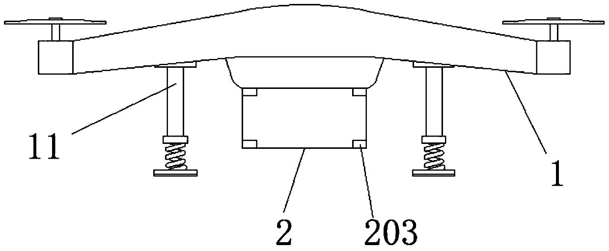
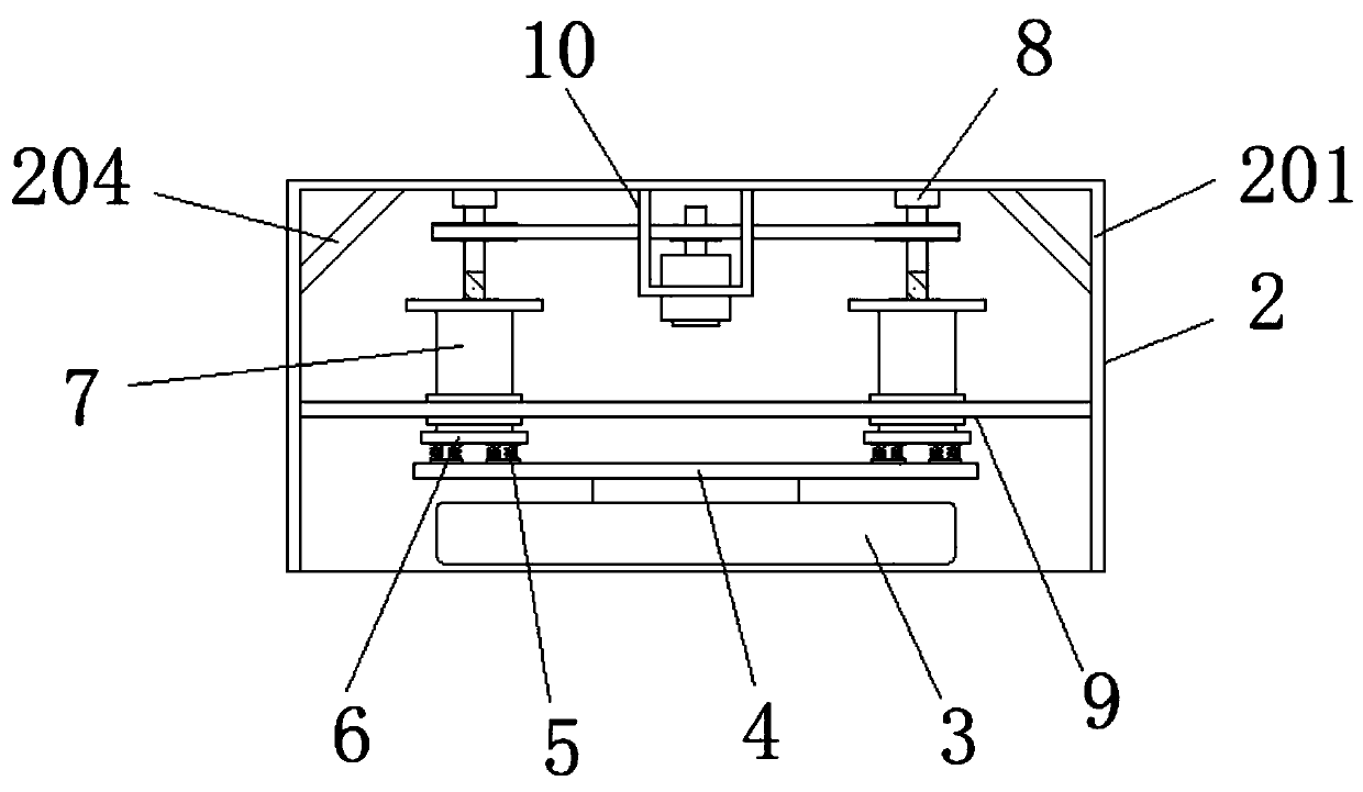
[0031] Such as Figure 1-8As shown, the present invention provides a technical solution: a drone-based engineering surveying and mapping device, including a drone 1 and a protection mechanism 2, the bottom surface of the drone 1 is equipped with a protection mechanism 2, and the protection An inclined surveying and mapping camera 3 is installed on one side of the bottom of the inner chamber of the mechanism 2, and a support plate 4 is installed on the top surface of the inclined surveying and mapping camera 3, and a shock absorbing frame mechanism 5 is installed on both sides of the top surface of the supporting plate 4, and the shock absorbing frame The mechanism 5 is specifically provided with several groups, the top surface of the shock absorber mechanism 5 is equipped with...


PUM


Abstract

The invention discloses a surveying and mapping device for engineering based on an unmanned aerial vehicle. The surveying and mapping device comprises the unmanned aerial vehicle and a protection mechanism, wherein the protection mechanism is mounted at the bottom surface of the unmanned aerial vehicle; an inclined surveying and mapping camera is mounted on one side of the bottom of an inner cavity of the protection mechanism; a supporting plate is mounted on the top surface of the inclined surveying and mapping camera; a plurality of shock-absorbing frame mechanisms are specifically mounted on two sides of the top surface of the supporting plate; and connecting plates are mounted on the top surfaces of the shock-absorbing frame mechanisms. The surveying and mapping device for engineeringbased on the unmanned aerial vehicle can protect internal equipment such as the inclined surveying and mapping camera, the shock-absorbing frame mechanisms, lifting mechanisms and the like through theprotection mechanism. A driving mechanism can drive the lifting and lowering of the lifting mechanisms. Meanwhile, a position-limiting mechanism also ensures that the lifting and lowering of the lifting mechanism can be more stable. The shock-absorbing frame mechanisms can also reduce external vibration so as to avoid damage to the inclined surveying and mapping camera. The engineering environment can be measured and recorded through the inclined surveying and mapping camera.

Description

technical field [0001] The invention relates to the technical field of surveying and mapping equipment, in particular to an engineering surveying and mapping device based on an unmanned aerial vehicle. Background technique [0002] Surveying and mapping engineering, measuring various information of space and land and drawing various topographic maps. Taking the shape, size and gravity field of the earth and other planets as the research object, the research and mapping objects are very extensive, mainly including various surface objects, landforms and underground geological structures, hydrology, mineral deposits, etc., such as mountains, rivers, Houses, roads, vegetation, etc. [0003] Usually before developing a piece of land or carrying out large-scale engineering construction, surveying and mapping engineers must measure and draw topographic maps and provide other information before they can make decisions, plan and design, so surveying and mapping work is very importan...

Claims


Application Information

Patent Timeline
Patent Type & Authority Applications(China)
IPC IPC(8): B64C39/02B64C25/62B64D47/08
CPCB64C39/02B64C25/62B64D47/08B64U2101/30B64U10/10
Inventor 陈蕾沈晔宋盛
Owner 江苏盐西土地整理开发有限公司
Why Eureka
Try Eureka