Remote sensing satellite imaging task autonomous aggregation method

A technology of remote sensing satellite and aggregation method, which is applied in the direction of integrated navigator, etc., and can solve the problem of low efficiency of remote sensing satellite tasks

Active Publication Date: 2020-03-27
BEIJING INST OF CONTROL ENG
View PDF3 Cites 11 Cited by
  • Summary
  • Abstract
  • Description
  • Claims
  • Application Information

AI Technical Summary

Problems solved by technology

[0003] The technical problem solved by the present invention is: to overcome the deficiencies of the prior art, to provide a remote sensing satellite imaging task autonomous aggregation method, and to solve the problem of remote sensing caused by the remote sensing satellite receiving earth observation tasks from multiple terminals in a local area. The problem of low mission efficiency of satellites per unit time is applicable to agile remote sensing satellites with autonomous mission capabilities, laying the foundation for efficient mission planning on board

Method used


Image

  • Remote sensing satellite imaging task autonomous aggregation method
  • Remote sensing satellite imaging task autonomous aggregation method
  • Remote sensing satellite imaging task autonomous aggregation method

Examples


Embodiment Construction

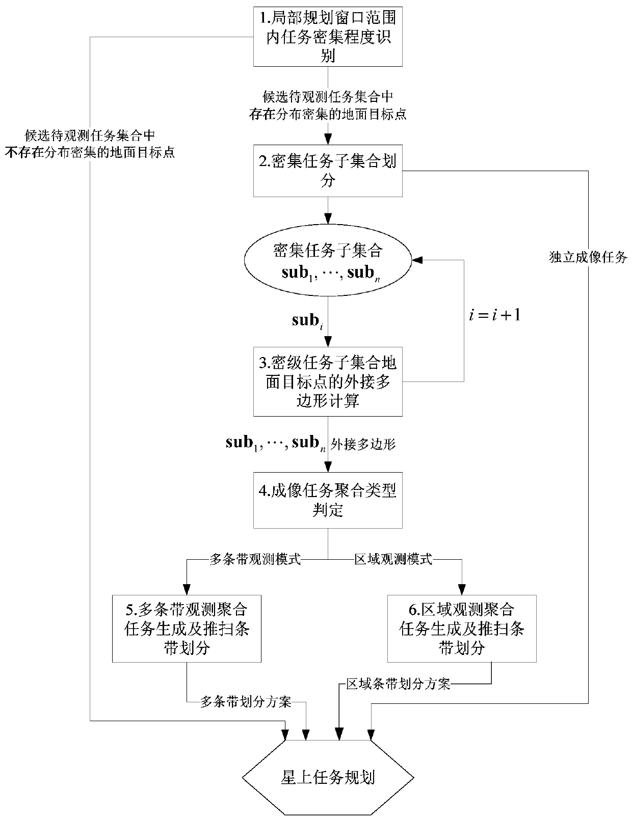
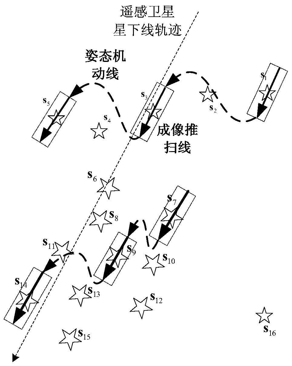
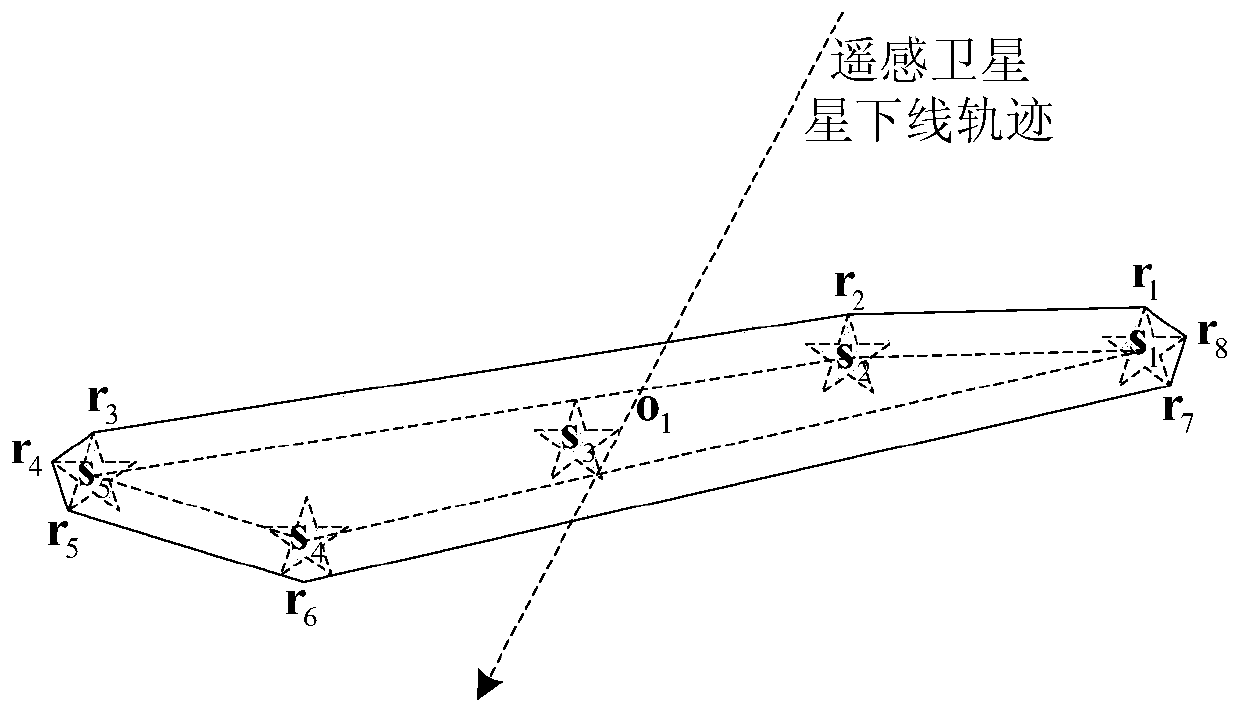
[0064] Autonomous mission planning technology can improve the intelligent autonomous operation of remote sensing satellites, the rapid response capabilities of tasks, and obtain greater economic benefits through the improvement of the application efficiency of remote sensing satellites, so it has a strong market demand. However, the earth observation missions from multiple terminals are not coordinated and managed on the ground. If they are densely distributed in local areas, the mission efficiency of remote sensing satellites per unit time will not be high. challenge.

[0065] Aiming at the scene where the existing technology cannot be applied to local intensive tasks in a complex environment, the present invention, from the perspective of engineering application, takes into account the non-along-track dynamic imaging capability and the strip splicing area imaging capability of agile remote sensing satellites. , a remote sensing satellite imaging task autonomous aggregation m...


PUM


Abstract

The invention discloses a remote sensing satellite imaging task autonomous aggregation method which comprises steps of firstly, identifying the task density degree in a local planning window range, judging whether the candidate to-be-observed task set needs autonomous aggregation of remote sensing satellite imaging tasks or not; when the autonomous aggregation is needed, dividing the candidate to-be-observed task set to obtain a plurality of dense task subsets; then, calculating external polygons of the dense task subsets respectively; determining a task aggregation mode of the dense task subsets according to the external polygons of the dense task subsets; dividing each dense task subset into a plurality of strip observation subtask sets and a region observation subtask set; and finally,generating a plurality of strip observation aggregation tasks according to the plurality of strip observation sub-task sets, performing push-broom strip division, generating a region observation aggregation task according to the plurality of region observation sub-task sets, and performing push-broom strip division to complete autonomous aggregation of the remote sensing satellite imaging task.

Description

technical field [0001] The invention relates to a remote sensing satellite imaging task autonomous aggregation method, which belongs to the technical field of spacecraft autonomous task planning. Background technique [0002] Remote sensing satellites with autonomous mission planning capabilities need to face the problem of multi-source complex task input. The task sources include imaging tasks proposed by multi-source end users, high-priority imaging tasks injected by ground emergency, and the passing of previous satellites in multi-satellite collaborative scenarios. The collaborative guidance mission sent by the inter-satellite link, and the imaging mission independently discovered and generated by the on-board perception and decision-making module. Because the above multi-source imaging tasks have not been coordinated and processed by the ground control system, there is a characteristic of dense distribution of ground targets to be observed in local areas. The existing r...

Claims


Application Information

Patent Timeline
Patent Type & Authority Applications(China)
IPC IPC(8): G01C21/24
CPCG01C21/24
Inventor 袁利朱琦张聪李勇瞿涵王云鹏李志辉
Owner BEIJING INST OF CONTROL ENG
Why Eureka
Try Eureka