Ozone pollution source identification method and system based on satellite remote sensing

A technology of satellite remote sensing and identification method, which is applied in the field of satellite remote sensing and can solve the problem of inability to accurately locate areas with heavy ozone pollution.

Active Publication Date: 2020-03-31
MINISTRY OF ECOLOGY & ENVIRONMENT CENT FOR SATELLITE APPL ON ECOLOGY ENVIRONMENT
View PDF5 Cites 17 Cited by
  • Summary
  • Abstract
  • Description
  • Claims
  • Application Information

AI Technical Summary

Problems solved by technology

90% of the ozone in the atmosphere is in the stratosphere and 10% in the troposphere. At the same time, most of the ozone precursors such as nitrogen oxides and VOCs emitted by man-made pollution sources are concentrated in the middle and lower layers of the troposphere. The concentration of ozone columns retrieved directly by satellite remote sensing cannot be accurate. Locate areas heavily polluted by ozone from anthropogenic emissions

Method used


Image

  • Ozone pollution source identification method and system based on satellite remote sensing
  • Ozone pollution source identification method and system based on satellite remote sensing
  • Ozone pollution source identification method and system based on satellite remote sensing

Examples


Embodiment Construction

[0049] In order to make the purpose, technical solutions and advantages of the embodiments of the present invention clearer, the technical solutions in the embodiments of the present invention will be clearly and completely described below in conjunction with the drawings in the embodiments of the present invention. Obviously, the described embodiments It is a part of embodiments of the present invention, but not all embodiments. Based on the embodiments of the present invention, all other embodiments obtained by persons of ordinary skill in the art without making creative efforts belong to the protection scope of the present invention.

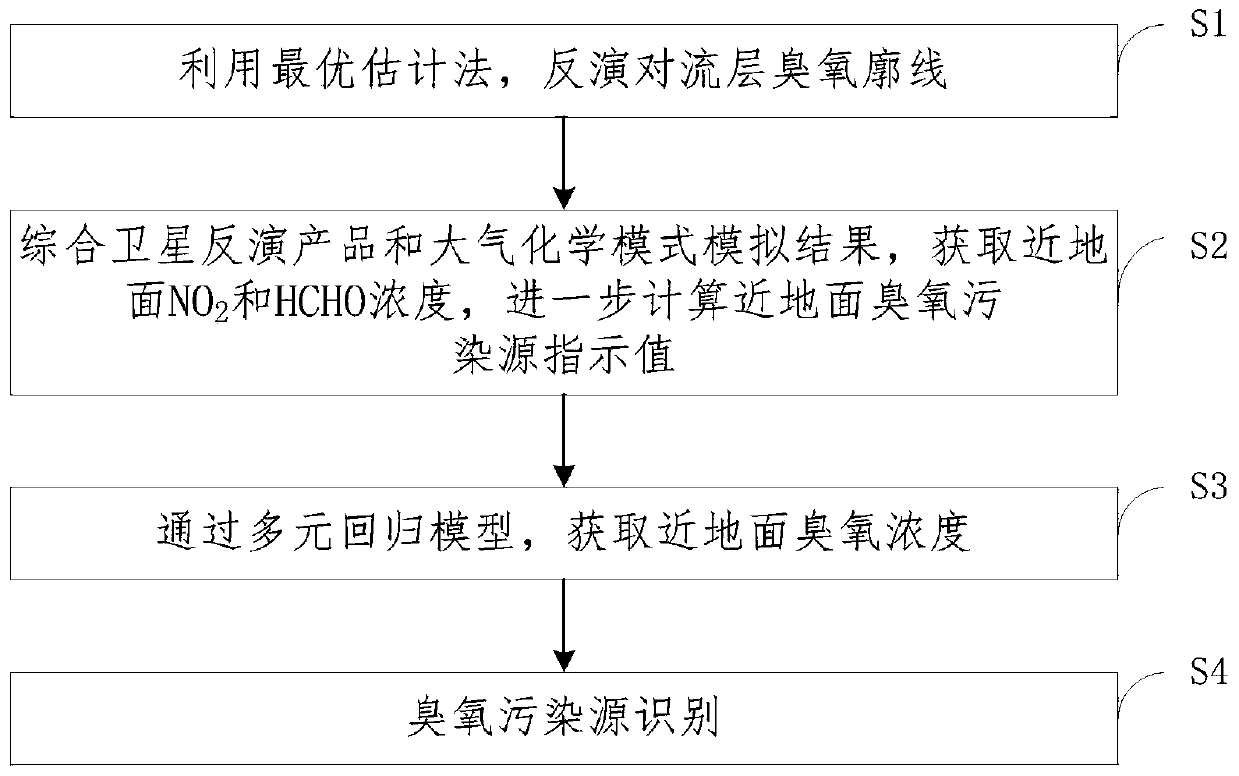
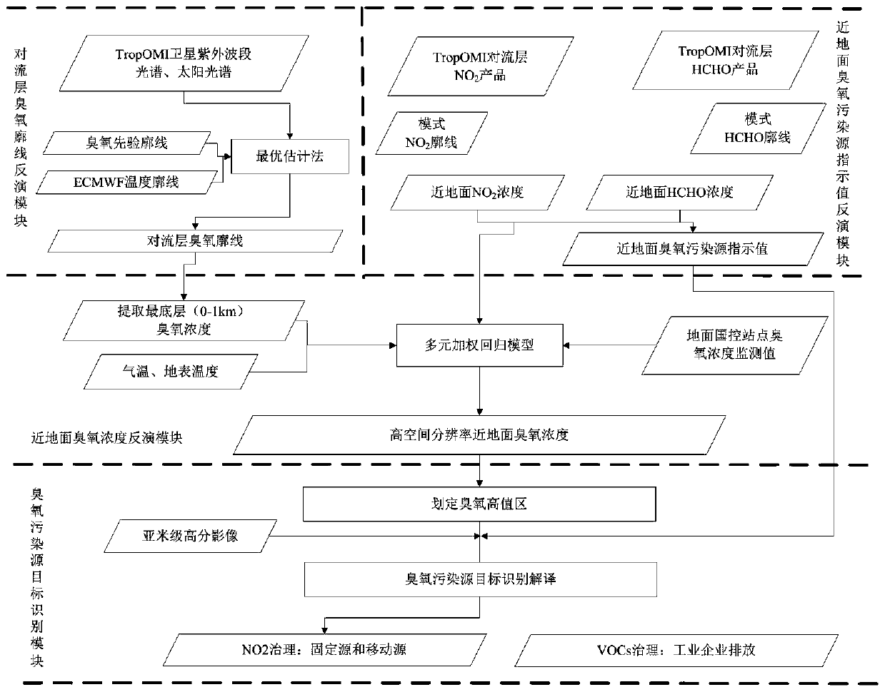
[0050] figure 1 A flow chart of a method for identifying ozone pollution sources based on satellite remote sensing provided by an embodiment of the present invention, such as figure 1 As shown, the method includes:

[0051] S1, step 1, using the optimal estimation method to invert the tropospheric ozone profile;

[0052] S2, step 2, integr...


PUM


Abstract

The embodiment of the invention provides an ozone pollution source identification method and system based on satellite remote sensing, and the system comprises 1) a tropospheric ozone profile inversion module which inverts a tropospheric ozone profile through TropOMI ultraviolet hyperspectral data; 2) a near-surface ozone pollution source indication value inversion module for obtaining the concentrations of near-surface NO2 and HCHO by using TropOMI troposphere NO2 and HCHO column concentration products in combination with an atmospheric chemical model Geos-Chem, and calculating the concentration ratio of the near-surface NO2 to the HCHO to obtain a near-surface ozone pollution source indication value; 3) a near-surface ozone concentration inversion module which integrates NO2, HCHO, ozonemonitoring values of ground national control stations and the like and acquires near-surface ozone concentration through a multiple regression model; and 4) an ozone pollution source target identification module for selecting an ozone heavy pollution area by using the near-surface ozone concentration result, and identifying the ozone pollution source by combining the near-surface ozone pollutionsource indication value and the sub-meter high-resolution image.

Description

technical field [0001] The invention relates to the technical field of satellite remote sensing, in particular to an ozone pollution source identification method and system based on satellite remote sensing. Background technique [0002] Near-surface ozone (O 3 ) pollution occurs frequently in summer, and ozone pollution is currently the most important pollution factor affecting the number of good days in a city. 90% of the ozone in the atmosphere is in the stratosphere and 10% in the troposphere. At the same time, most of the ozone precursors such as nitrogen oxides and VOCs emitted by man-made pollution sources are concentrated in the middle and lower layers of the troposphere. The concentration of ozone columns retrieved directly by satellite remote sensing cannot be accurate. Locate areas heavily polluted by ozone from anthropogenic emissions. Therefore, how to obtain the near-surface ozone concentration and find the source of ozone pollution immediately and accurately...

Claims


Application Information

Patent Timeline
Patent Type & Authority Applications(China)
IPC IPC(8): G06K9/00G06K9/62G16C20/70G06F17/16G06F17/18G01N21/17
CPCG06F17/16G06F17/18G16C20/70G01N21/17G01N2021/1793G06V20/13G06F18/241
Inventor 马鹏飞陈辉陈翠红胡奎伟张连华张丽娟张玉环翁国庆王中挺厉青周春艳毛慧琴
Owner MINISTRY OF ECOLOGY & ENVIRONMENT CENT FOR SATELLITE APPL ON ECOLOGY ENVIRONMENT
Why Eureka
Try Eureka