Urban green land automatic extraction method based on unmanned aerial vehicle data
An automatic extraction and unmanned aerial vehicle technology, applied in the field of urban surveying and mapping, can solve the problems of large manpower and time, and achieve the effect of fast speed, flexible data acquisition and high resolution
- Summary
- Abstract
- Description
- Claims
- Application Information
AI Technical Summary
Problems solved by technology
Method used
Image

Examples
Embodiment Construction
[0020] The following clearly and completely describes the technical solutions in the embodiments of the present invention. Obviously, the described embodiments are only some of the embodiments of the present invention, but not all of them.
[0021] An embodiment provided by the invention: a method for automatically extracting urban green spaces based on drone data, comprising the following steps:
[0022] Step 1: Prepare the drone, select the surveying range, and design the shooting route and shooting height;
[0023] Step 2: Start the drone for shooting, the shooting height is 250-500m, the shooting height is adjusted by the weather visibility of the day and the focal length of the camera lens of the drone;
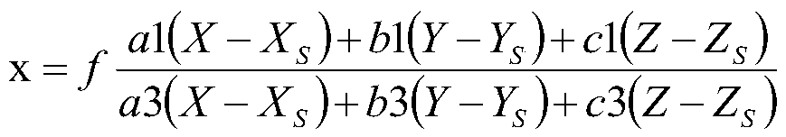
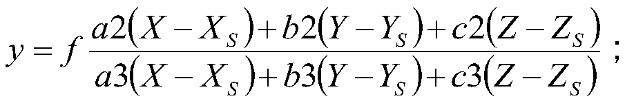
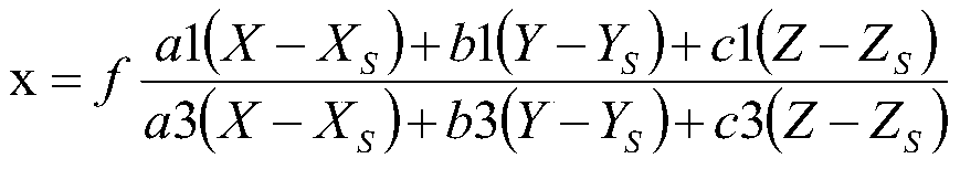
[0024] Step 3: Perform distortion correction on the captured original image, perform aerial triangulation, and then perform splicing, correction and color correction to obtain an orthophoto;
[0025] Step 4: Automatically interpret by computer, and then use the method o...
PUM
 Abstract
Description
Claims
Application Information
PatSnap Eureka turns technology decisions into work you can execute. Powered by our Innovation Knowledge Graph, it runs expert workflows across engineering, life sciences, materials and intellectual property. Get your review-ready output in minutes.


