Aerial photography integrated method

An aerial photography and aerial camera technology, applied in the field of photography, can solve problems such as inability to meet digital production, and achieve the effects of improving production methods, improving operating methods, and reducing quantity

Inactive Publication Date: 2020-04-10
AERIAL PHOTOGRAMMETRY & REMOTE SENSING CO LTD +4
View PDF10 Cites 3 Cited by
  • Summary
  • Abstract
  • Description
  • Claims
  • Application Information

AI Technical Summary

Problems solved by technology

[0003] In the traditional aerial photogrammetry (aerial survey) mapping process, the field adopts the method of field mapping and small pen tip ink, and the internal industry then conducts mapping. However, this method can no longer meet the needs of digital production. The integration method of aerial survey and internal field, which is completed directly on the original image, has become the development trend of aerial survey and mapping.

Method used


Image

  • Aerial photography integrated method

Examples


Embodiment Construction

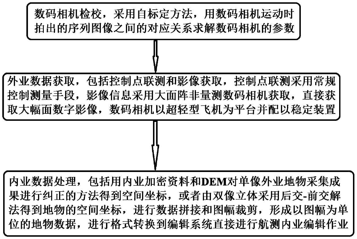
[0040] see figure 1 , an integrated method of aerial photography, using a small-scale aerial photogrammetry system based on digital images, the system is composed of an ultralight aircraft platform, a single array digital aerial camera and a data processing system, and the method is based on a digital camera and an ultralight aircraft platform aerial photogrammetry, including the following steps:

[0041] Step 1, digital camera calibration, adopts the self-calibration method, does not require calibration objects as a reference, and does not require the digital camera to move according to a specific trajectory, only needs to use the correspondence between the sequence images taken when the digital camera moves Relational solver number camera parameters.

[0042] In this embodiment, a digital camera calibration method based on the essential matrix and the fundamental matrix is ​​adopted. This method first finds the corresponding relationship between the matching points between...


PUM


Abstract

The invention provides an aerial photography integrated method. A small aerial photogrammetry system based on digital images is adopted, and the system is composed of an ultra-light aircraft platform,a single-sided array digital aerial camera and a data processing system. The method is based on aerial photogrammetry of the digital camera and the ultra-light aircraft platform, and comprises the following steps: Step 1, calibration of the digital camera: solving parameters of the digital camera by using a corresponding relation between sequence images shot when the digital camera moves by adopting a self-calibration method; Step 2, field data acquisition; 3, indoor data processing, including: using a method of correcting a single-image field ground object acquisition result by using indoorencrypted data and a DEM to obtain a space coordinate, or obtaining space coordinates of the ground object by adopting a post-intersection-pre-intersection method through two-image stereo, carrying out data splicing and feature clipping, forming ground object data with the map sheet as the unit, and carrying out format conversion to an editing system to directly carry out aerial survey indoor editing operation.

Description

technical field [0001] The invention relates to the technical field of photography, in particular to an integrated aerial photography method. Background technique [0002] Photogrammetry and remote sensing is the process, science and technology of obtaining reliable information about the earth, its environment and other objects from non-contact imaging and other sensor systems through recording, measurement, analysis and expression. Among them, photogrammetry focuses on extracting geometric information, and remote sensing focuses on extracting physical information. That is to say, photogrammetry obtains information about the earth, its environment and other objects from a non-contact imaging system through recording, measurement, analysis and expression. The art, science and technology of reliable information on geometry, properties, etc. Aerial photogrammetry is an aircraft flying according to a certain required route. For ground photography, there is a certain degree of o...

Claims


Application Information

Patent Timeline
IPC IPC(8): G01C11/04G01C11/06
CPCG01C11/04G01C11/06
Inventor 田江博孙倩陈红安孙银博
Owner AERIAL PHOTOGRAMMETRY & REMOTE SENSING CO LTD
Why Eureka
Try Eureka