Unmanned aerial vehicle autonomous landing system and landing method based on GPS and vision

An autonomous landing and UAV technology, applied in the field of UAV landing system based on GPS and vision, can solve the problems of insufficient landing accuracy and insufficient landing safety, and achieve the effect of improving landing accuracy and increasing safety

Pending Publication Date: 2020-04-14
NANJING UNIV OF INFORMATION SCI & TECH
View PDF6 Cites 13 Cited by
  • Summary
  • Abstract
  • Description
  • Claims
  • Application Information

AI Technical Summary

Problems solved by technology

At present, UAV technology already has the function of autonomous flight, and can also realize autonomous landing, but the autonomous landing system is a GPS-based UAV autonomous landing system, which still has the disadvantages of insufficient landing accuracy and insufficient landing safety.

Method used


Image

  • Unmanned aerial vehicle autonomous landing system and landing method based on GPS and vision
  • Unmanned aerial vehicle autonomous landing system and landing method based on GPS and vision
  • Unmanned aerial vehicle autonomous landing system and landing method based on GPS and vision

Examples


Embodiment

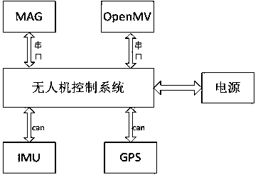
[0025] like figure 1 As shown, a kind of unmanned aerial vehicle autonomous landing system based on GPS and vision of the present embodiment, comprises unmanned aerial vehicle control system and the GPS module, MAG module, IMU module, openmv module, atmospheric pressure that are respectively connected with unmanned aerial vehicle control system Sensor module and power supply module; The GPS module is used to obtain longitude and latitude data in real time, and send to the UAV control system; The MAG module collects MAG data in real time and sends it to the UAV control system, for carrying out the UAV heading Control; the IMU module collects IMU data in real time and sends it to the drone control system for attitude control of the drone; the openmv module is used to capture environmental images, and the collected images are processed and converted to obtain The coordinate difference of the UAV relative to the landing position in the image; the atmospheric pressure sensor module...


PUM


Abstract

The invention relates to an unmanned aerial vehicle autonomous landing system and landing method based on GPS and vision. The method comprises the steps: enabling an unmanned aerial vehicle to receivea one-key return instruction in a normal flight process, enabling the unmanned aerial vehicle to maintain a normal flight height, starting to fly to a first landing position right above a landing point, and employing a GPS positioning system in the process; after the unmanned aerial vehicle arrives at the first-section landing position, the unmanned aerial vehicle starts to descend to a second-section landing position 5 m away from the position over the target at the vertical speed of 5 m/s, and a GPS is adopted in the process; after the unmanned aerial vehicle reaches the second-section landing position, the unmanned aerial vehicle starts to descend to the ground at the vertical speed of 1 m/s, and a visual positioning system is adopted in the process; and after the unmanned aerial vehicle reaches the ground, the unmanned aerial vehicle blades stop rotating. According to the unmanned aerial vehicle autonomous landing system, a GPS and visual positioning method is adopted, and the landing precision of the unmanned aerial vehicle is improved to the maximum extent.

Description

technical field [0001] The invention relates to the technical field of unmanned aerial vehicles, in particular to a GPS and vision-based unmanned aerial vehicle landing system and method. Background technique [0002] In recent years, UAV technology has developed rapidly. Due to the characteristics of UAVs such as flexibility, portability, low cost and high efficiency, UAVs have a large space for development in fields such as agricultural plant protection, power inspection, and terrain detection. At present, UAV technology already has the function of autonomous flight, and can also realize autonomous landing, but the autonomous landing system is a GPS-based UAV autonomous landing system, which still has the disadvantages of insufficient landing accuracy and insufficient landing safety. . Contents of the invention [0003] In order to solve the problems in the prior art, the present invention provides a GPS and vision-based autonomous landing system and landing method for ...

Claims


Application Information

Patent Timeline
Patent Type & Authority Applications(China)
IPC IPC(8): B64D45/04B64D45/08G05D1/10
CPCB64D45/04B64D45/08G05D1/101
Inventor 葛男男孙伟曹界宇
Owner NANJING UNIV OF INFORMATION SCI & TECH
Why Eureka
Try Eureka