Supercharge Your Innovation With Domain-Expert AI Agents!

Method for identifying acid veins by utilizing thermal infrared hyperspectral remote sensing

A hyperspectral remote sensing and identification method technology, applied in the field of identification of acidic dikes, can solve the problems of poor extraction accuracy of acidic dikes, insufficient spectral fineness, and low spatial resolution

Pending Publication Date: 2020-04-21
BEIJING RES INST OF URANIUM GEOLOGY
View PDF2 Cites 0 Cited by
  • Summary
  • Abstract
  • Description
  • Claims
  • Application Information

AI Technical Summary

Problems solved by technology

[0005] Aiming at the deficiencies of the above existing technologies, a method for identifying acidic dikes using thermal infrared hyperspectral remote sensing is provided to solve the problems of poor extraction accuracy, low spatial resolution, and insufficient spectral fineness in the prior art. technical problem

Method used


Image

  • Method for identifying acid veins by utilizing thermal infrared hyperspectral remote sensing
  • Method for identifying acid veins by utilizing thermal infrared hyperspectral remote sensing
  • Method for identifying acid veins by utilizing thermal infrared hyperspectral remote sensing

Examples


Embodiment Construction

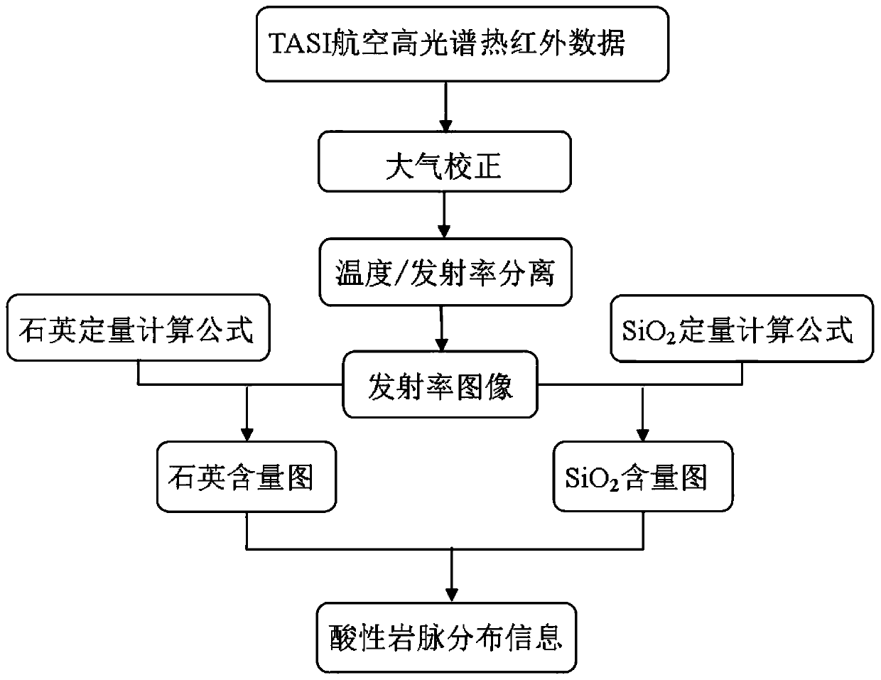
[0036] A method for identifying acidic dikes using thermal infrared hyperspectral remote sensing of the present invention will be described in detail below in conjunction with the accompanying drawings and embodiments.

[0037] A method for identifying acidic dikes using thermal infrared hyperspectral remote sensing of the present invention firstly preprocesses thermal infrared hyperspectral remote sensing data; then performs atmospheric correction and emissivity separation to obtain emissivity images; and then respectively SiO 2 Quantitative calculation of content and quartz mineral content, the SiO 2 content map and quartz mineral content map; then with high SiO 2 Bands of non-high quartz are designated as acid dikes.

[0038] Such as figure 1 As shown, a method for identifying acidic dikes using thermal infrared hyperspectral remote sensing of the present invention specifically includes the following steps:

[0039] Step 1. Thermal infrared hyperspectral remote sensing ...


PUM

PropertyMeasurementUnit
wavelengthaaaaaaaaaa

Abstract

The invention belongs to the technical field of combination of remote sensing information technology and tectonic geology, and particularly relates to a method for identifying acid veins by utilizingthermal infrared hyperspectral remote sensing. The method comprises the following steps of: preprocessing thermal infrared hyperspectral remote sensing data; performing atmospheric correction on the thermal infrared hyperspectral remote sensing data; separating the temperature / emissivity of the thermal infrared hyperspectral data; obtaining a SiO2 content diagram; acquiring a quartz mineral content diagram; and obtaining acid vein information. Aiming at different physicochemical properties of acid veins, tuff sandstones and siliceous veins, quantitative calculation of SiO2 and quartz contentsis carried out by utilizing a remote sensing technology, so that distribution information of the acid veins in a tuff sandstone area can be rapidly and accurately extracted, and the positions and forms of the acid veins are determined.

Description

technical field [0001] The invention belongs to the technical field of combining remote sensing information technology and structural geology, and in particular relates to a method for identifying acidic dikes by using thermal infrared hyperspectral remote sensing. Background technique [0002] Acidic dikes are formed under the comprehensive action of geological activities such as tectonic movement and acidic magmatic activity. Therefore, accurately identifying and determining the location and distribution of acidic dykes is very important for analyzing and simulating the direction of tectonic movement, mechanical properties and magma. The nature of the activity plays a huge role. [0003] The rapid identification and large-scale coverage of remote sensing can quickly and effectively identify acidic dikes distributed in a wide range. However, there are many kinds of remote sensing data, and thermal infrared remote sensing is the best band range for identifying acidic dikes....

Claims


Application Information

Patent Timeline
Patent Type & Authority Applications(China)
IPC IPC(8): G01N21/3563G01N21/27G01V8/02
CPCG01N21/3563G01N21/274G01V8/02
Inventor 郭帮杰张杰林王俊虎周觅武鼎
Owner BEIJING RES INST OF URANIUM GEOLOGY
Features
  • R&D
  • Intellectual Property
  • Life Sciences
  • Materials
  • Tech Scout
  • Unparalleled Data Quality
  • Higher Quality Content
  • 60% Fewer Hallucinations
Learn More