Check patentability & draft patents in minutes with Patsnap Eureka AI!

Covariance intersection-based unmanned combat vehicle simultaneous positioning and map establishing method

A technology of covariance intersection and map construction, applied in the field of unmanned chariot navigation, can solve the problems of pure inertial navigation system navigation error accumulation, which cannot fully meet the practical application

Active Publication Date: 2020-05-01
BEIJING AUTOMATION CONTROL EQUIP INST
View PDF5 Cites 4 Cited by
  • Summary
  • Abstract
  • Description
  • Claims
  • Application Information

AI Technical Summary

Problems solved by technology

Pure inertial navigation systems cannot fully meet the needs of practical applications due to their inherent shortcomings of navigation errors accumulating over time

Method used


Image

  • Covariance intersection-based unmanned combat vehicle simultaneous positioning and map establishing method
  • Covariance intersection-based unmanned combat vehicle simultaneous positioning and map establishing method
  • Covariance intersection-based unmanned combat vehicle simultaneous positioning and map establishing method

Examples


Embodiment Construction

[0065] The present invention will be further described below through specific embodiments.

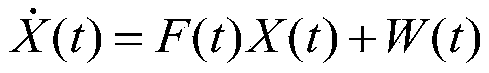
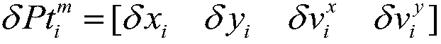
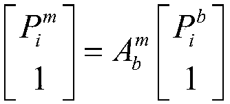
[0066] This project uses raster-scale maps as the representation method of the map model. Use the global coordinate system as the coordinate system for environment modeling, take the starting position of the unmanned combat vehicle as the origin, the geographic north direction is the x-axis of the global coordinate system, and the geographic east direction is the y-axis of the global coordinate system.

[0067] 1. Lidar system feature modeling and extraction

[0068] First, separate the distance information obtained by the laser radar system: the laser radar system generates a large amount of data at the same time. In order to extract environmental features more accurately from a large amount of data, it is necessary to use a clustering algorithm to cluster the scanning points. The amount of data generated at the same time is divided into different blocks, and a certain block cannot b...


PUM


Abstract

The invention belongs to the unmanned combat vehicle navigation technology, and particularly relates to a covariance intersection-based unmanned combat vehicle simultaneous positioning and map establishing method. Firstly, a system state estimation model is established, then environment feature coordinates are calculated, a measurement matrix is calculated, Kalman filtering is adopted for system state error estimation, feedback correction is carried out on inertial navigation system errors and feature point errors according to a Kalman filtering optimal estimation result, and environment feature coordinate calculation and system state error estimation are carried out after system error correction is completed. The method can improve the precision of the inertial system, and improve the navigation precision and the modeling precision of an environment model. Under the condition that various sensor information on the unmanned combat vehicle can be obtained, the observation information ofthe environmental features is combined with the inertial navigation system by using a plurality of sensors to obtain the optimal position estimation of the unmanned combat vehicle at each moment andthe environment map model represented by the environmental features, so that the high-precision positioning of the unmanned combat vehicle and the map modeling function of the surrounding environmentare realized.

Description

technical field [0001] The invention belongs to the navigation technology of an unmanned combat vehicle, and in particular relates to a simultaneous positioning and map construction method of an unmanned combat vehicle based on covariance intersection. Background technique [0002] As the long-term and long-distance driving capabilities of ground vehicles continue to increase, the requirements for the accuracy and autonomy of navigation systems are also increasing. The pure inertial navigation system cannot fully meet the needs of practical applications due to its inherent disadvantage that navigation errors accumulate over time. The purpose of constructing the environment map model is to obtain the optimal position estimation of the unmanned combat vehicle at each moment, and to solve the high-precision navigation of the long-endurance unmanned combat vehicle and the demand for environmental situation awareness. [0003] The representation methods of the map model include ...

Claims


Application Information

Patent Timeline
IPC IPC(8): G01C21/00G01C21/20
CPCG01C21/005G01C21/20
Inventor 孙伟刘冲李海军原润钟润伍蔡善军裴玉锋
Owner BEIJING AUTOMATION CONTROL EQUIP INST
Features
  • R&D
  • Intellectual Property
  • Life Sciences
  • Materials
  • Tech Scout
  • Unparalleled Data Quality
  • Higher Quality Content
  • 60% Fewer Hallucinations
Learn More