A multi-rotor UAV inspection path planning method

A technology of multi-rotor UAV and inspection path, which is applied in the direction of navigation calculation tools, etc., and can solve the problem that there are few researches on full-coverage path planning methods

Active Publication Date: 2020-08-04
JIANGSU FRONTIER ELECTRIC TECH
View PDF7 Cites 1 Cited by
  • Summary
  • Abstract
  • Description
  • Claims
  • Application Information

AI Technical Summary

Problems solved by technology

[0003] At present, the application of multi-rotor UAVs and related path planning algorithms mainly have the following problems: First, there are few researches on full-coverage path planning methods for multi-rotor UAVs in 3D space for 3D object structures; The inspection path mostly takes the shortest path as the inspection target, fails to consider the influence of natural wind factors and light conditions on track planning, and cannot effectively integrate the safety constraints for the performance of towers and multi-rotor UAVs to achieve optimal path planning

Method used


Image

  • A multi-rotor UAV inspection path planning method
  • A multi-rotor UAV inspection path planning method
  • A multi-rotor UAV inspection path planning method

Examples


Embodiment Construction

[0065] The present invention will be further described below in conjunction with the accompanying drawings of the specification and specific preferred embodiments.

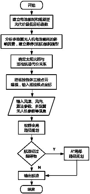
[0066] Such as figure 1 As shown, a multi-rotor UAV inspection path planning method is characterized in that the path planning is completed by improving the ant colony algorithm and the improved A* hybrid algorithm by taking the battery energy consumption and the lowest cost of avoiding backlighting as the objective function; Proceed as follows:

[0067] Step 1. In order to ensure the safety and low energy consumption of the inspection, establish the minimum objective function of battery energy consumption and avoiding backlight cost;

[0068] Step 2: Analyze the factors affecting the battery energy consumption of the multi-rotor UAV inspection and determine the hovering energy consumption and cruise energy consumption;

[0069] Step 3. Determine the relationship between the sun's illumination and the patrol track of the ...


PUM


Abstract

The invention is a multi-rotor UAV inspection path planning method. First, in order to ensure the safety and low energy consumption of the inspection, the minimum objective function of battery energy consumption and avoiding backlight cost is established; Check the influencing factors of battery energy consumption, determine hovering energy consumption and cruising energy consumption; determine the relationship between solar illumination and multi-rotor UAV inspection track; model the 3D point cloud model of the scanned object to be inspected, At the same time, input the coordinates of all viewpoints in the cruise process; use the improved ant colony algorithm to output the optimal cruise path, use the improved A* hybrid algorithm to output the optimal flight path between two adjacent viewpoints, and finally output the optimal flight path. This method can determine the energy consumption and the impact of sunlight on track planning during the cruising process of the UAV, provide a safe, low energy consumption, and avoid backlight optimal path for the UAV inspection, and improve the automatic patrol of multi-rotor UAVs. Check safety and reliability.

Description

Technical field [0001] The invention relates to the technical field of track planning for a multi-rotor unmanned aerial vehicle, in particular to a multi-rotor unmanned aerial vehicle inspection path planning method. Background technique [0002] With the development of the aviation industry and technology, the use of multi-rotor drones for inspections has become a recent research focus. Multi-rotor drones are not only light in weight, small in size, and low in cost; they are also highly flexible and easy to control; they can achieve efficient and comprehensive inspection services through manual or automatic methods. Multi-rotor drones are equipped with various visible light, infrared, ultraviolet or laser equipment to perform inspection tasks together, which will be able to comprehensively detect and grasp the safety of the object to be detected. Multi-rotor drones fly according to a certain route, collect images or videos to obtain the equipment status and surrounding environm...

Claims


Application Information

Patent Timeline
Patent Type & Authority Patents(China)
IPC IPC(8): G01C21/20
CPCG01C21/20
Inventor 黄郑王红星潘志新周航宋煜黄祥张星炜赵宏伟
Owner JIANGSU FRONTIER ELECTRIC TECH
Why Eureka
Try Eureka