A Parabola-Based Calculation Method of Regional Tropospheric Wet Delay
A calculation method, tropospheric technology, applied in the field of global navigation systems, to achieve the effect of improving accuracy
- Summary
- Abstract
- Description
- Claims
- Application Information
AI Technical Summary
Problems solved by technology
Method used
Image
Examples
Embodiment Construction
[0033] In order to make the object, technical solution and advantages of the present invention clearer, the specific implementation cases of the present invention will be described below in conjunction with the accompanying drawings.
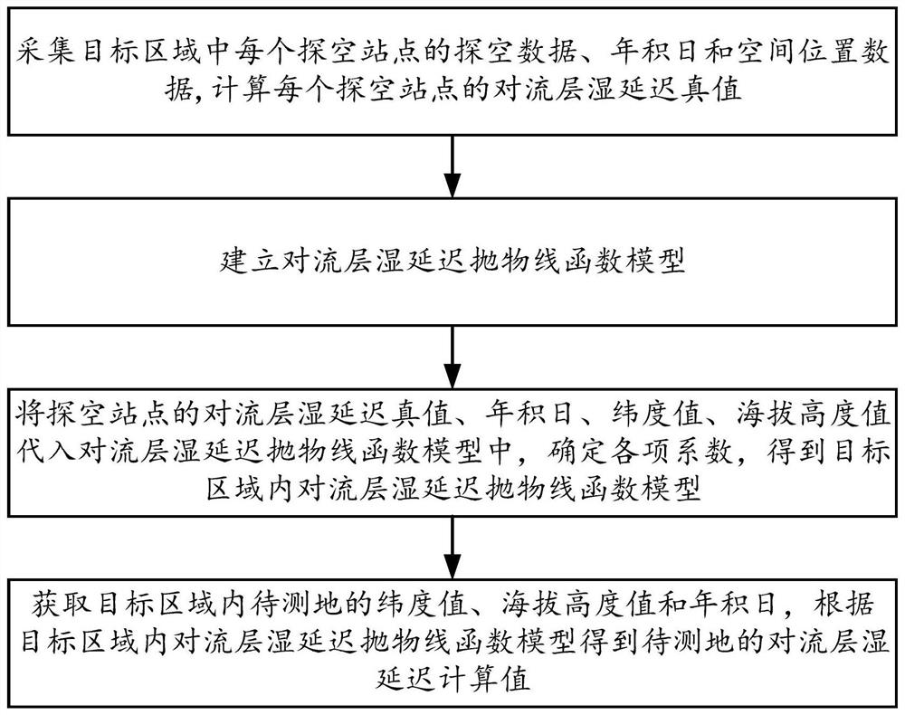
[0034] The invention discloses a parabola-based regional tropospheric wet delay calculation method, the flow of which is as follows figure 1 shown, including:
[0035] S1: Collect the sounding data, yearly date and spatial position data of each sounding station in the target area, and calculate the true tropospheric wet delay T of each sounding station based on the collected sounding data ZWD ; The spatial location data is a latitude value and an altitude value;
[0036] Table 1 Meteorological data of 1028 sounding stations
[0037] PRES HGHT TEMP DWPT RELH MIXR DRCT SKNT THTA THTE THTV hPa m C C % g / kg deg knot K K K 1009 18 -3.5 -5.1 89 2.6 135 12 269 276.1 269.4 1003 65 -2....
PUM
 Abstract
Description
Claims
Application Information
 - R&D
- Intellectual Property
- Life Sciences
- Materials
- Tech Scout
- Unparalleled Data Quality
- Higher Quality Content
- 60% Fewer Hallucinations
Browse by: Latest US Patents, China's latest patents, Technical Efficacy Thesaurus, Application Domain, Technology Topic, Popular Technical Reports.
© 2025 PatSnap. All rights reserved.Legal|Privacy policy|Modern Slavery Act Transparency Statement|Sitemap|About US| Contact US: help@patsnap.com


