Unmanned aerial vehicle route early warning method and device, equipment and storage medium

An early warning device and unmanned aerial vehicle technology, applied in the field of visual measurement, can solve the problems of large positioning error, large amount of calculation, expensive laser radar, etc., and achieve the effect of improving accuracy and safety

Active Publication Date: 2020-06-23
丰翼科技(深圳)有限公司
View PDF19 Cites 14 Cited by
  • Summary
  • Abstract
  • Description
  • Claims
  • Application Information

AI Technical Summary

Problems solved by technology

Among them, lidar is expensive and has a huge amount of calculation; ultrasonic is mostly used in indoor scenes, and the positioning error is relatively large
Binocular vision is limited by the distance between the two cameras, and is not suitable for distance measurement of distant objects

Method used


Image

  • Unmanned aerial vehicle route early warning method and device, equipment and storage medium
  • Unmanned aerial vehicle route early warning method and device, equipment and storage medium
  • Unmanned aerial vehicle route early warning method and device, equipment and storage medium

Examples


Embodiment Construction

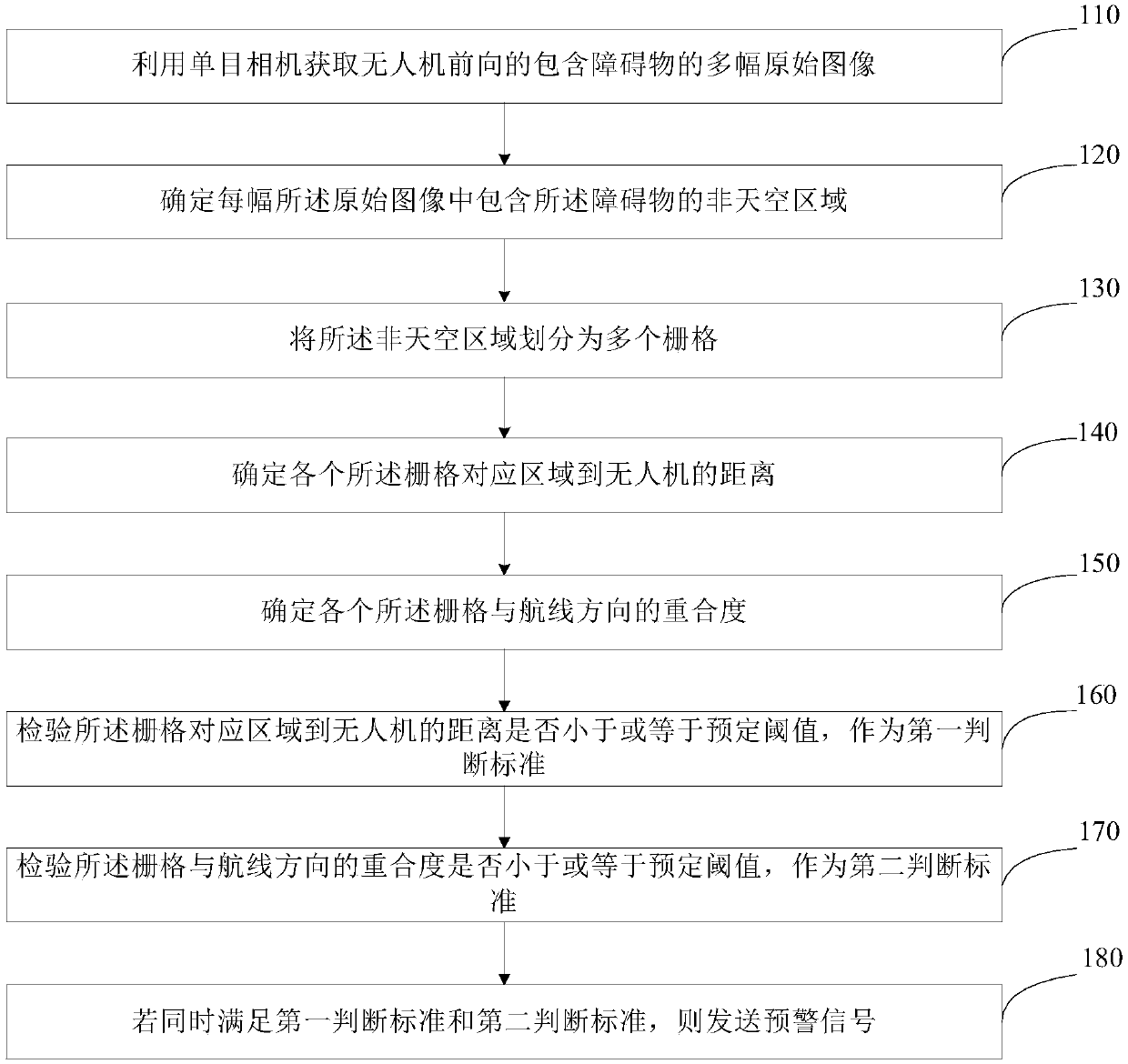
[0064] The application will be further described in detail below in conjunction with the accompanying drawings and embodiments. It should be understood that the specific embodiments described here are only used to explain related inventions, rather than to limit the invention. It should also be noted that, for ease of description, only parts related to the invention are shown in the accompanying drawings.

[0065] It should be noted that, in the case of no conflict, the embodiments in the present application and the features in the embodiments can be combined with each other.

[0066] The development of the micro-UAV vision system has gone through three stages: the first stage is the precise shooting and storage of picture information, and the main task is to collect images, such as aerial photography; the second stage is the search for stationary targets , recognition and positioning, and performing work such as target recognition; the third stage is to use the recognized im...


PUM


Abstract

The invention discloses an unmanned aerial vehicle route early warning method and device, equipment and a storage medium. The method comprises the following steps: acquiring a plurality of forward original images containing obstacles of the unmanned aerial vehicle by using a monocular camera; determining a non-sky area containing the obstacle in each original image; dividing the non-sky area intoa plurality of grids; determining the distance from the area corresponding to each grid to the unmanned aerial vehicle; determining the overlap ratio of each grid and the course direction; checking whether the distance between the area corresponding to the grid and the unmanned aerial vehicle is smaller than or equal to a preset threshold value or not; checking whether the overlap ratio of the grid and the course direction is smaller than or equal to a preset threshold value or not; and if the conditions are simultaneously met, sending an early warning signal. According to the technical schemeprovided by the embodiment of the invention, remote obstacle detection and early warning are realized, so that the safety of the unmanned aerial vehicle in the navigation flight process can be effectively improved.

Description

technical field [0001] The present invention generally relates to the field of visual measurement, in particular to a method, device, equipment and storage medium for early warning of UAV routes. Background technique [0002] During the flight of UAV routes, uncontrollable obstacle information is often encountered, such as birds, mountains, and flying objects. of. Among them, lidar is expensive and has a huge amount of calculation; ultrasonic is mostly used in indoor scenes, and the positioning error is relatively large. Binocular vision is limited by the distance between the two cameras, and is not suitable for distance measurement of distant objects. After the obstacle is detected, it is necessary to combine the current UAV route information to propose a stable and effective obstacle early warning mechanism. [0003] Based on the above problems, it is necessary to realize visual obstacle detection and distance information acquisition, and to propose an effective early w...

Claims


Application Information

Patent Timeline
Patent Type & Authority Applications(China)
IPC IPC(8): G08G5/00G08G5/04
CPCG08G5/0069G08G5/04
Inventor 王浩毛曙源
Owner 丰翼科技(深圳)有限公司
Why Eureka
Try Eureka