Multi-dimensional spatial data rendering method and device

A multi-dimensional space and data rendering technology, applied in image data processing, 3D image processing, instruments, etc., can solve the problems of incomplete and inaccurate spatial data rendering results, improve rendering efficiency, comprehensive display, and improve rendering The effect of efficiency

Active Publication Date: 2020-06-30
PLA STRATEGIC SUPPORT FORCE INFORMATION ENG UNIV PLA SSF IEU
View PDF8 Cites 9 Cited by
  • Summary
  • Abstract
  • Description
  • Claims
  • Application Information

AI Technical Summary

Problems solved by technology

[0005] The purpose of this application is to provide a multi-dimensional spatial data rendering method and device to solve the problem of incomplete and inaccurate rendering results of existing spatial data

Method used


Image

  • Multi-dimensional spatial data rendering method and device
  • Multi-dimensional spatial data rendering method and device
  • Multi-dimensional spatial data rendering method and device

Examples


Embodiment Construction

[0022] Embodiment of multi-dimensional spatial data rendering method:
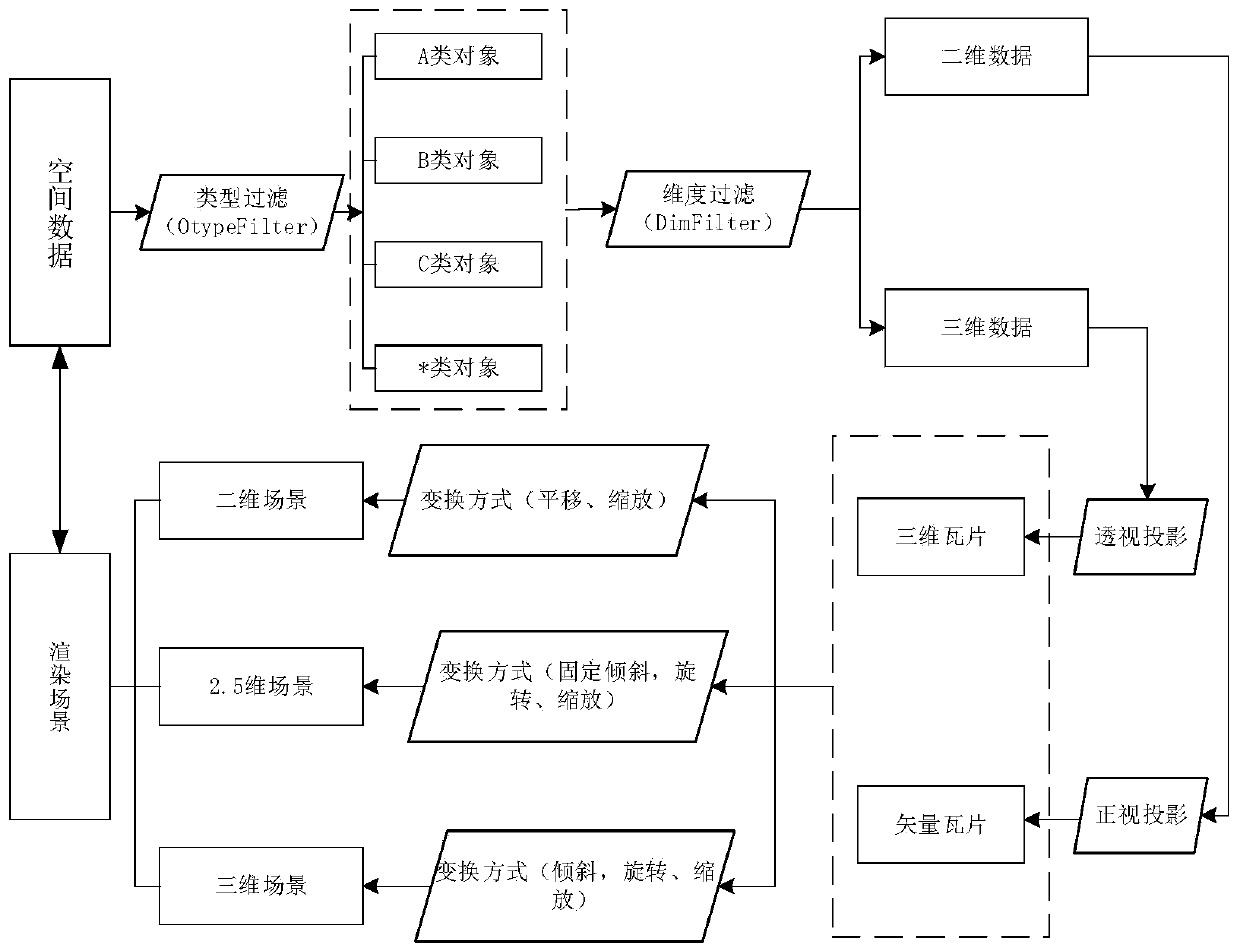
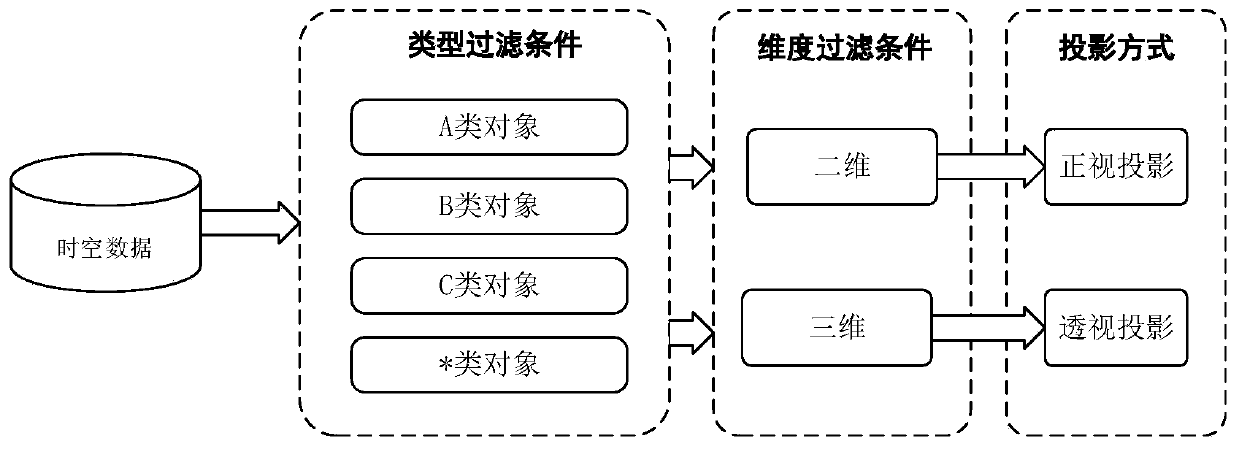
[0023] The main idea of ​​the present invention is to input the multi-dimensional spatial data into the rendering model established by the present invention, in the rendering model, perform type filtering and dimension filtering on the multi-dimensional spatial data, and then obtain two-dimensional data and three-dimensional data under each type of data; Perform corresponding projection transformation on the two-dimensional data and three-dimensional data under each type of data to obtain the vector tiles and three-dimensional tiles of each type of data; according to the dimension requirements of the display scene, the obtained vector tiles and three-dimensional The tile performs the scene transformation of the corresponding dimension, and outputs and displays the result of the scene transformation in the rendering model.

[0024] The multi-dimensional spatial data rendering method proposed in this embodim...


PUM


Abstract

The invention relates to a multi-dimensional spatial data rendering method and device, and belongs to the technical field of spatial data visual expression. The method comprises the steps of obtainingmulti-dimensional spatial data, performing type filtering on the multi-dimensional spatial data, and performing dimension filtering on each type of data to obtain two-dimensional data and three-dimensional data under each type of data; performing corresponding projection transformation on the two-dimensional data and the three-dimensional data under each type of data to obtain a vector tile and athree-dimensional tile of each type of data; and according to the dimension requirement of the display scene, performing scene transformation of the corresponding dimension on the obtained vector tiles and three-dimensional tiles of each type of data, and performing rendering display according to a scene transformation result. According to the method, unified rendering is carried out on each typeof data of each dimension, rendering efficiency is improved, scene transformation of the corresponding dimension can be carried out on the vector tiles and the three-dimensional tiles according to the dimension requirements of the display scene, display of different scene dimensions of the spatial data is achieved, and display is more comprehensive and more accurate.

Description

technical field [0001] The invention relates to a multi-dimensional spatial data rendering method and device, and belongs to the technical field of spatial data visualization expression. Background technique [0002] Originating from the GIS of map management and overlay analysis, most of the spatial data managed in the early days were two-dimensional and planar map data. With the continuous development of modern society, the level of urban space is becoming more and more complex (overpasses, skyscrapers, urban pipe network), and the means of space observation are becoming more and more abundant (satellites, radar, infrared, sonar). Comprehensive and more three-dimensional spatial data, on the other hand, also poses new challenges to the visual expression of GIS spatial data. [0003] At present, the mainstream GIS spatial data rendering models can be divided into two-dimensional GIS rendering models based on Map-Layer and three-dimensional GIS rendering models based on Sce...

Claims


Application Information

Patent Timeline
Patent Type & Authority Applications(China)
IPC IPC(8): G06T15/00
CPCG06T15/00
Inventor 张江水王培曹一冰杨飞杨振凯张毅
Owner PLA STRATEGIC SUPPORT FORCE INFORMATION ENG UNIV PLA SSF IEU
Why Eureka
Try Eureka