Method for elimination of electronic map interest point label covering of roads

An electronic map and point-of-interest technology, applied to road network navigators and other directions, can solve problems such as slow processing speed of capped roads, affecting user navigation experience, capping of point-of-interest labels, etc., to improve navigation user experience and reduce capping Calculate the amount and solve the effect of background road area coverage

Active Publication Date: 2015-01-14
XIAMEN YAXON NETWORKS CO LTD
View PDF7 Cites 16 Cited by
  • Summary
  • Abstract
  • Description
  • Claims
  • Application Information

AI Technical Summary

Problems solved by technology

In car navigation applications, the road is the most critical information, and many points of interest appear on the edge of the road; when there are too many points of interest on the edge of the road, the phenomenon that the label of the point of interest covers the road occurs from time to time; in severe cases, it may affect the road display, or even Covering key information such as details of complex intersections, affecting the user's navigation experience
To eliminate the coverage of roads by POI labels in the electronic map, it is first necessary to detect whether the POI labels in the electronic map cover the roads. In a conventional detection method, all roads in the road layer are compared with each POI label one by one. The calculation is very large and there are many irrelevant and invalid calculations; another detection method is for an interest point label, and the roads in a certain local area (for example, within 500 meters) around the interest point are taken out to perform the cover judgment calculation , in order to reduce the amount of detection calculations; because there are many points of interest and the positions of each point of interest are different, for each point of interest, it is necessary to dynamically search and divide the corresponding local area from a large amount of map data, and the calculation consumption is also very large
The processing speed of the two methods for detecting POI labels and capping roads is slow, which cannot meet the needs of electronic map navigation under the current situation of rapid urban and rural construction in my country, many changes in roads, and frequent increases and changes of POIs.

Method used


Image

  • Method for elimination of electronic map interest point label covering of roads
  • Method for elimination of electronic map interest point label covering of roads
  • Method for elimination of electronic map interest point label covering of roads

Examples


Embodiment 1

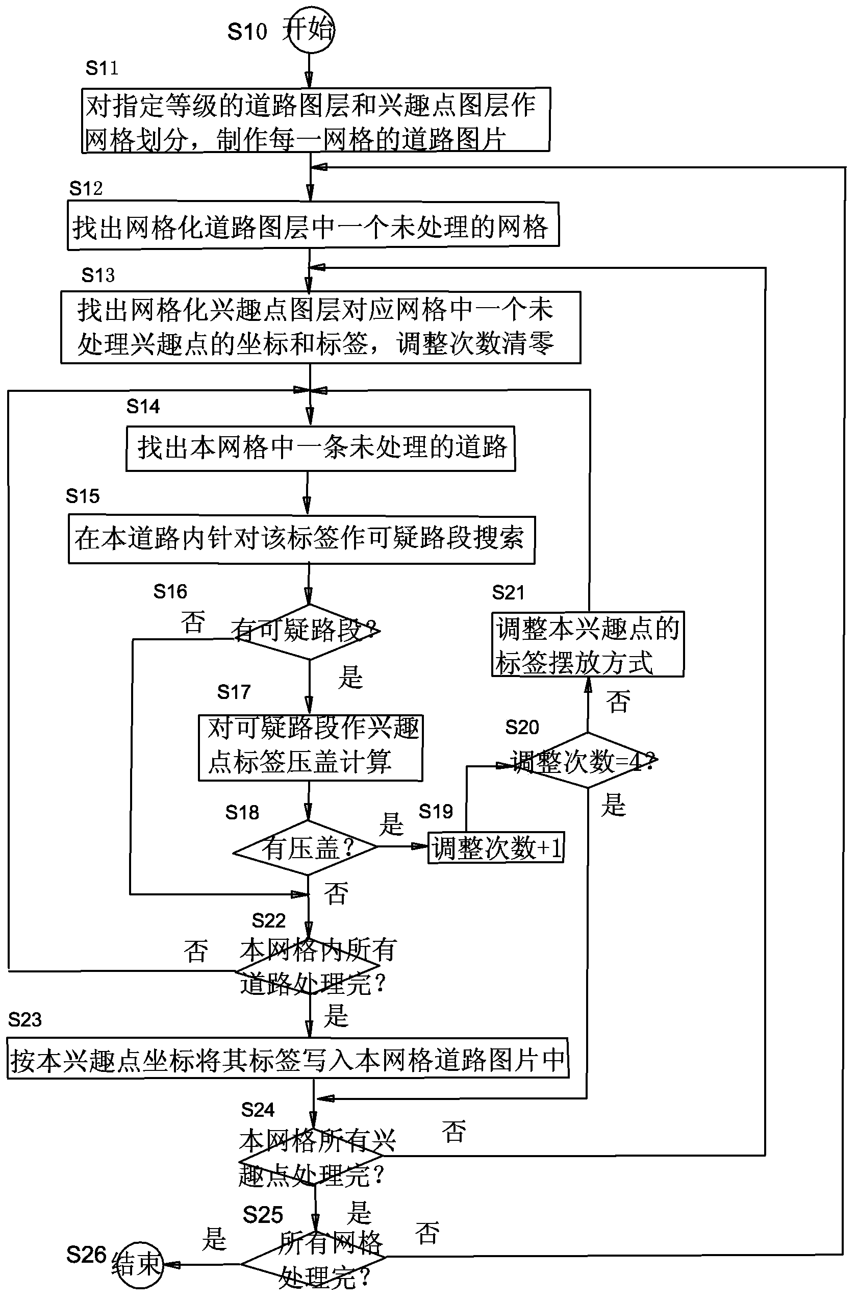
[0083] In the electronic map, the road layer is used to record all straight-line sections of each road, and the point-of-interest layer is used to record the coordinates and labels of each point of interest. For a segment r n For example, using its two endpoints r n1 、r n2 To indicate that for a point of interest, its coordinates are marked as P(Px,Py), and the position of its label is marked as T(Tleft,Ttop,Tright,Tbottom). Among them, Px, Py represent the abscissa and ordinate values ​​of the POI position on the electronic map, and Tleft, Ttop, Tright, and Tbottom represent the coordinate values ​​of the left, upper, right, and lower edges of the rectangular POI label on the electronic map .

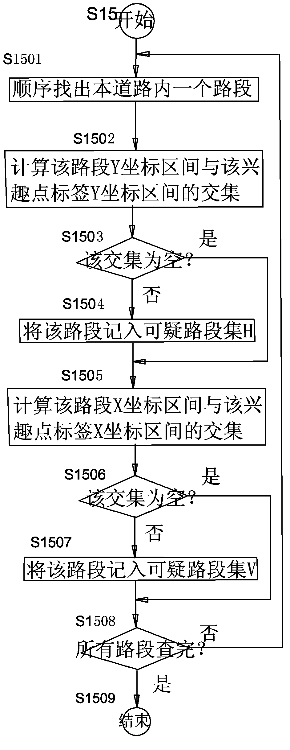
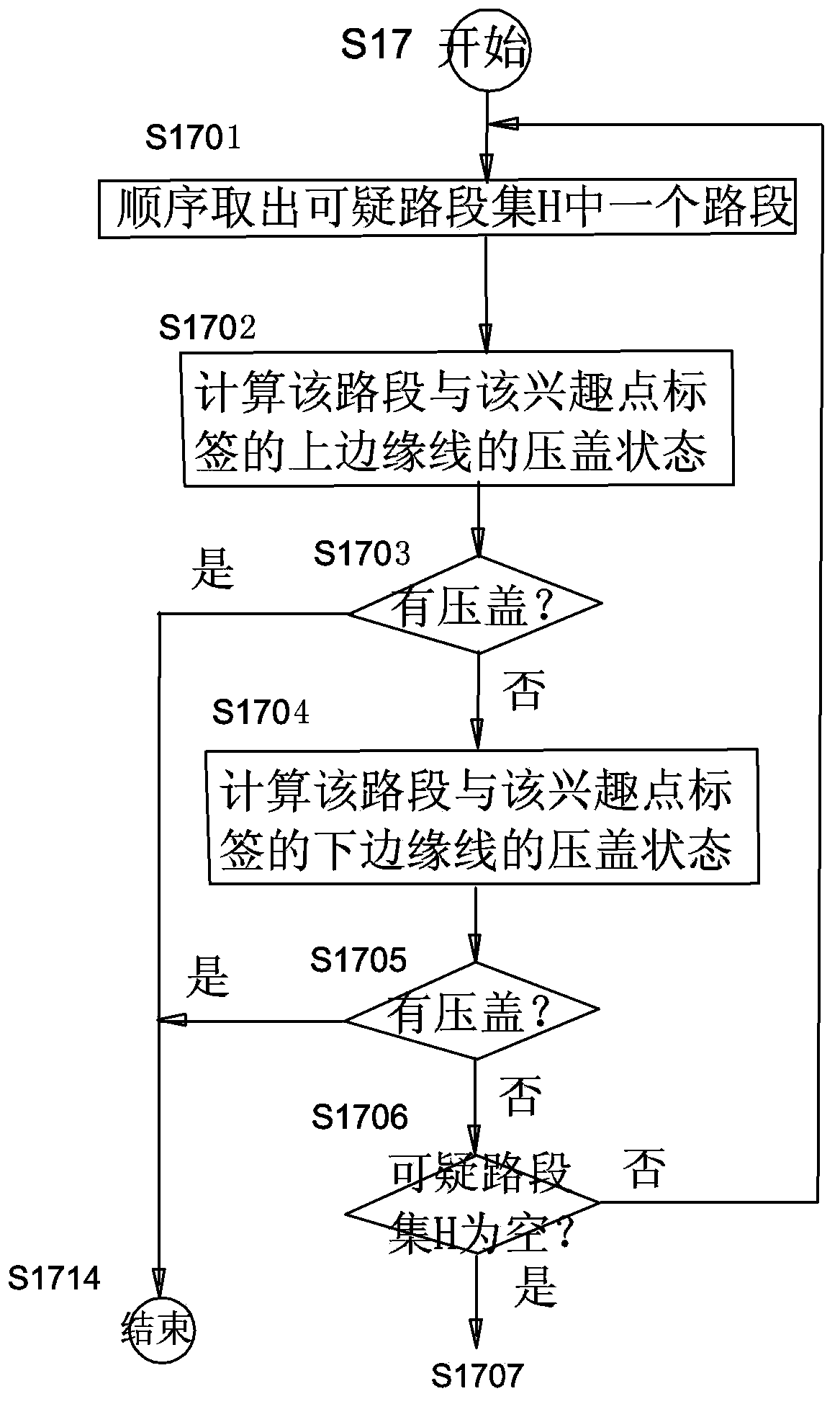
[0084] For the processing flow chart of an embodiment of the method for eliminating the label of the point of interest in the electronic map to cover the road in the present invention, please refer to figure 1 . The process consists of the following steps:

[0085] Step S10, star...


PUM


Abstract

The invention discloses a method for elimination of electronic map interest point label covering of roads and relates to an electronic map modification method. The method comprises the following steps of A, carrying out mesh division on a specified level of road and interest point layers, making a road picture of each mesh and going to step B, B, if the road layer contains an unprocessed mesh, finding the unprocessed mesh and going to step C, or stopping the process otherwise, C, if the corresponding mesh in the interest point layer contains an unprocessed interest point, finding a label of the unprocessed interest point and going to step D, or going to the step B otherwise, D, if the mesh contains an unprocessed road, finding the unprocessed road and going to step E, or going to step G otherwise, E, carrying out suspicious road section search aiming at the interest point coordinates and labels on all the sections of the road, and if a suspicious road section exists, going to step F, or going to the step D otherwise, F, carrying out interest point label covering computation on the suspicious road section, and if the suspicious road section is covered, adjusting a label arrangement mode, labeling all the roads in the mesh as unprocessed roads and going to the step D, or going to step G otherwise, and G, writing the label into the road pictures in the mesh and executing the step C.

Description

technical field [0001] The invention relates to a method for modifying an electronic map. Background technique [0002] When generating an electronic map, it is necessary to use point-of-interest tags (POI tags) to describe points of interest in text, so that users (users) can quickly understand the geographical environment. Placing POI labels in electronic maps is a very important issue. A good drawing operation should try to avoid or reduce POI labels covering key areas in the map background. In car navigation applications, the road is the most critical information, and many points of interest appear on the edge of the road; when there are too many points of interest on the edge of the road, the phenomenon that the label of the point of interest covers the road occurs from time to time; in severe cases, it may affect the road display, or even Covering key information such as complex intersection details affects the user's navigation experience. In order to eliminate the ...

Claims


Application Information

Patent Timeline
Patent Type & Authority Applications(China)
IPC IPC(8): G01C21/26
CPCG01C21/32
Inventor 涂岩恺季刚簧家乾
Owner XIAMEN YAXON NETWORKS CO LTD
Why Eureka
Try Eureka