Vehicle positioning and navigation method and device and related system

A vehicle positioning and vehicle technology, applied in the field of navigation, can solve problems such as inaccurate positioning, inaccurate vehicle guidance information, and wrong roads

Active Publication Date: 2020-07-07
SHENYANG MXNAVI CO LTD
View PDF7 Cites 20 Cited by
  • Summary
  • Abstract
  • Description
  • Claims
  • Application Information

AI Technical Summary

Problems solved by technology

Moreover, since the accuracy of satellite positioning in the prior art is generally at the meter level, vehicle positioning deviations may occur, for example, positioning a vehicle currently driving on a road side road to the main road of the road
In addition, since there are often multiple lanes on roads in the real world, existing positioning methods are used to locate the vehicle on the road on the road map, but cannot determine the lane where the vehicle is located, so it can only provide road-level path planning or path guidance. information
Since the existing positioning method cannot locate which lane of the road the vehicle is driving in, and cannot provide lane-level lane-changing guidance information based on the current position of the vehicle, it may cause the driver to find out that the vehicle needs to move to the solid-line area after the vehicle reaches the solid line area. Changing lane to the right, but already in the solid line area at this time, can no longer change lane to the right, and can only continue driving on the straight road
It can be seen that using the existing positioning method, when there are many lanes on the road, it may happen that the positioning is not accurate enough, causing the vehicle to go the wrong way because the guidance information is not detailed.
If accurate lane-level positioning cannot be achieved, lane-level navigation routes or guidance information cannot be provided
[0003] However, the existing lane-level map matching technology needs to store high-precision map data to match the type and color of the lane, and determine the lane where the current vehicle is located. However, high-precision data does not store lane information for all roads. Higher roads, such as high-speed, urban express, etc. will store lane information, and roads with lower road grades, such as urban roads, will not store lane information (that is, the location information and type of specific lanes will not be stored, but will be stored number of lane lines)
When the vehicle is driving on a road with a relatively low road grade, the lane information identified by the camera cannot be matched with high-precision data

Method used


Image

  • Vehicle positioning and navigation method and device and related system
  • Vehicle positioning and navigation method and device and related system
  • Vehicle positioning and navigation method and device and related system

Examples


Embodiment 1

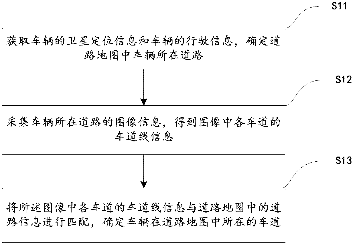
[0046] The embodiments of the present invention provide a vehicle positioning method for the above-mentioned problems in the prior art, such as figure 1 As shown, the method includes the following steps S11-S13:

[0047] S11: Obtain the satellite positioning information of the vehicle and the driving information of the vehicle, obtain the absolute position information of the vehicle, and determine the road where the vehicle is located in the road map according to the absolute position information of the vehicle.

[0048] The satellite positioning information of the vehicle can be obtained by using existing satellite positioning systems, such as the Global Positioning System (GPS), BeiDou Navigation Satellite System (BDS) or Global Navigation Satellite System (Global Navigation Satellite System). System, GLONASS); the driving information of the vehicle can include the speed information of the vehicle and the steering information of the vehicle. The speed information of the vehicle an...

example 1

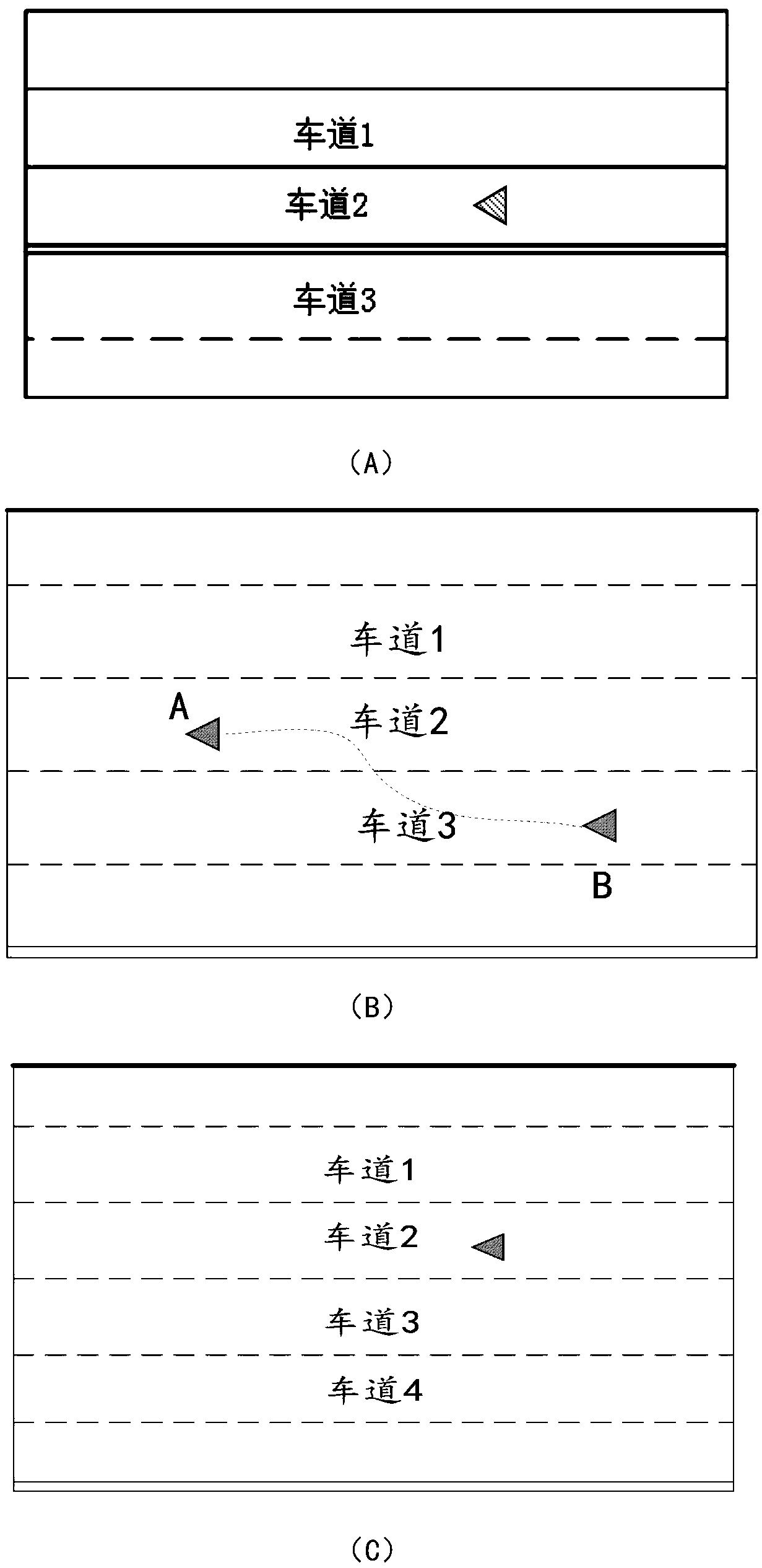
[0057] Example one, such as image 3 As shown in (A), during the driving process of the vehicle, according to the image information of the road where the vehicle is located at the current moment, it can be determined that there are two lanes on the left and right sides of the vehicle, that is, the road in the image includes lanes 1 to Lane 3 has 3 lanes, and the types of the 4 lanes from lane 1 to lane 3 are single solid line, single solid line, double solid line and single dashed line from left to right. Among them, the type of lane line in the image There is a special lane line in the vehicle (the triangle in the figure), that is, there is a double solid line on the left side of the lane where the vehicle is located. According to the number of lanes on the road where the vehicle is located in the road map, there are three lanes, that is, four lane lines, then the vehicle can be determined to be on the road map In the leftmost lane of the road.

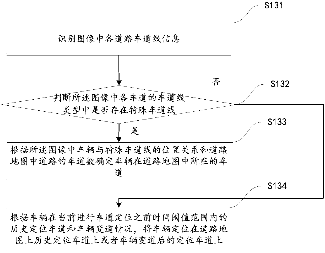
[0058] S134: According to the ve...

example 3

[0061] Example three, such as image 3 As shown in (C), during the driving process of the vehicle, according to the image information of the road where the vehicle is located at the current moment, it can be determined that there are two lanes on the left and right sides of the vehicle, that is, the road in the image includes 3 lanes , And the types of the 4 lanes are all single dashed lines, and there is no historical positioning lane within the time threshold T1 before the current lane positioning. According to the number of lanes on the road where the vehicle is located in the road map, the lane line The number is 7. According to the road attributes, it can be known that the rightmost lane line is the edge line of the road. It can be seen that there are 5 white dashed lines on the road. It is not clear whether the vehicle positioning position is on lane 2 or lane 3. According to the traffic rules, it is to keep to the right, and the vehicle is positioned on the designated roa...


PUM


Abstract

The invention provides a vehicle positioning and navigation method and device and a related system. The method comprises the following steps: firstly, acquiring satellite positioning information and driving information of a vehicle, obtaining absolute position information of the vehicle, and determining a road where the vehicle is located in a road map according to the absolute position information of the vehicle; then, collecting image information of the road where the vehicle is located to obtain lane line information of each lane in an image; and finally matching the lane line information of each lane in the image with the road information in the road map to determine the lane where the vehicle is located in the road map. According to the invention, lane-level vehicle positioning is realized, the positioning accuracy is improved, the vehicle positioning error is reduced, and the problem of inaccurate vehicle positioning in the prior art is solved. According to the acquired lane-level vehicle positioning information, lane-level path planning can be realized, and a lane-level navigation route or path guiding information can be provided.

Description

Technical field [0001] The present invention relates to the field of navigation technology, in particular to a vehicle positioning and navigation method and device and related systems. Background technique [0002] At present, in the prior art, the positioning of the vehicle through the satellite navigation system can only locate the vehicle on the road. According to the position of the vehicle on the road, route planning or route guidance is performed. Moreover, since the accuracy of satellite positioning in the prior art is generally at the meter level, vehicle positioning deviation may occur, for example, positioning a vehicle currently driving on a road side road to the main road of the road. In addition, because real-world roads often have multiple lanes, the existing positioning method is used to locate the vehicle on the road on the road map, and the lane where the vehicle is located cannot be determined, so it can only provide road-level path planning or path guidance. ...

Claims


Application Information

Patent Timeline
Patent Type & Authority Applications(China)
IPC IPC(8): G01C21/30G01C21/34G01C21/36G01S19/45
CPCG01C21/30G01C21/343G01C21/3602G01C21/3691G01S19/45
Inventor 周健
Owner SHENYANG MXNAVI CO LTD
Why Eureka
Try Eureka