A vehicle autonomous navigation method based on image matching/inertial navigation/odometer

An autonomous navigation and odometer technology, applied in the field of positioning and navigation, can solve the problems of limited application scenarios and low precision, and achieve the effects of overcoming data source asynchrony, high precision, and strong anti-interference

Active Publication Date: 2021-11-09
CENT SOUTH UNIV
View PDF0 Cites 0 Cited by
  • Summary
  • Abstract
  • Description
  • Claims
  • Application Information

AI Technical Summary

Problems solved by technology

[0008] The purpose of the present invention is to provide a vehicle autonomous navigation method based on image matching / inertial navigation / odometer, which aims to solve the problems of low accuracy and limited application scenarios of common methods of vehicle autonomous navigation

Method used


Image

  • A vehicle autonomous navigation method based on image matching/inertial navigation/odometer
  • A vehicle autonomous navigation method based on image matching/inertial navigation/odometer
  • A vehicle autonomous navigation method based on image matching/inertial navigation/odometer

Examples


Embodiment 1

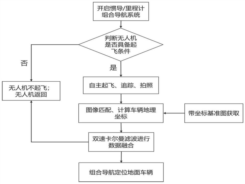
[0073] see Figure 1 to Figure 4 , a vehicle autonomous navigation method based on image matching / inertial navigation / odometer, comprising the following steps:

[0074] Step 1: Configure an unmanned aerial vehicle equipped with a ground camera on the ground vehicle that needs to be positioned;

[0075] Step 2: Start the vehicle-mounted inertial navigation / odometer integrated navigation system, and the driver will judge whether the UAV has the conditions for take-off when the vehicle is in motion;

[0076] Step 3: If the take-off conditions are met, the UAV (unmanned aerial vehicle) will take off autonomously and track the vehicle autonomously. At the same time, it will take pictures of the ground and use the captured real-time image to match the reference map made in advance to realize the positioning of the ground vehicle;

[0077] Step 4: After obtaining the positioning result, send it to the vehicle navigation computer for data fusion;

[0078] Step 5: After obtaining the...


PUM


Abstract

The invention provides a vehicle autonomous navigation method based on image matching / inertial navigation / odometer. Configure an unmanned aerial vehicle equipped with a ground-facing camera on the ground vehicle that needs to be positioned; start the vehicle-mounted inertial navigation / odometer integrated navigation system, and the driver will judge whether the unmanned aerial vehicle has the conditions to take off when the vehicle is in motion; if When the take-off conditions are met, the UAV takes off autonomously and tracks the vehicle autonomously. At the same time, it takes pictures of the ground and uses the captured real-time image to match the reference map made in advance to realize the positioning of the ground vehicle; after obtaining the positioning result, it is sent to the vehicle navigation computer for data fusion; After the vehicle positioning results, the UAV autonomously lands and returns to the vehicle. The present invention proposes a new navigation scheme, which uses a UAV to carry an aerial camera, and performs template matching on the real-time aerial image and the reference gallery, thereby determining the geographical coordinates of the vehicle in the real-time aerial image, and correcting the inertial navigation / mileage of the matching positioning result Calculated combined navigation error.

Description

technical field [0001] The invention relates to the technical field of positioning and navigation, in particular to a vehicle autonomous navigation method based on image matching / inertial navigation / odometer. Background technique [0002] The commonly used method for vehicle positioning is a navigation method based on the fusion of satellite navigation (GNSS) and inertial navigation (INS). The disadvantage of this navigation method is that when the GNSS signal is interfered, blocked or spoofed, the navigation performance of the integrated navigation system will be significantly reduced, which cannot meet the needs of vehicle navigation. With the development of intelligent technology, the demand for autonomous navigation technology that does not rely on external information is increasing. Typical applications include unmanned vehicles and military special vehicles. It can be expected that unmanned vehicles will be widely used in the fields of logistics, personnel transportat...

Claims


Application Information

Patent Timeline
Patent Type & Authority Patents(China)
IPC IPC(8): G01C21/16G01C21/34
CPCG01C21/165G01C21/3415
Inventor 韩松来罗世林芦佳振罗世彬
Owner CENT SOUTH UNIV
Why Eureka
Try Eureka