Positioning system and positioning method of global navigation satellite system (GNSS) monitoring station

A positioning system and monitoring station technology, applied in satellite radio beacon positioning system, radio wave measurement system, measuring device, etc., can solve the problem of out-of-synchronization of monitoring satellites, achieve high-precision positioning, ensure high precision, and ensure accuracy and computational efficiency effects

Active Publication Date: 2018-12-25
GUILIN UNIV OF ELECTRONIC TECH
View PDF5 Cites 6 Cited by
  • Summary
  • Abstract
  • Description
  • Claims
  • Application Information

AI Technical Summary

Problems solved by technology

[0005] The technical problem to be solved by the present invention is to provide a positioning system for GNSS monitoring stations aiming at the asynchrony of GNSS monitoring stations and GNSS reference station monitoring satellites in the above-mentioned prior art, resulting in deficiencies in positioning GNSS monitoring station positions by GNSS reference stations and positioning method

Method used


Image

  • Positioning system and positioning method of global navigation satellite system (GNSS) monitoring station
  • Positioning system and positioning method of global navigation satellite system (GNSS) monitoring station
  • Positioning system and positioning method of global navigation satellite system (GNSS) monitoring station

Examples


Embodiment 1

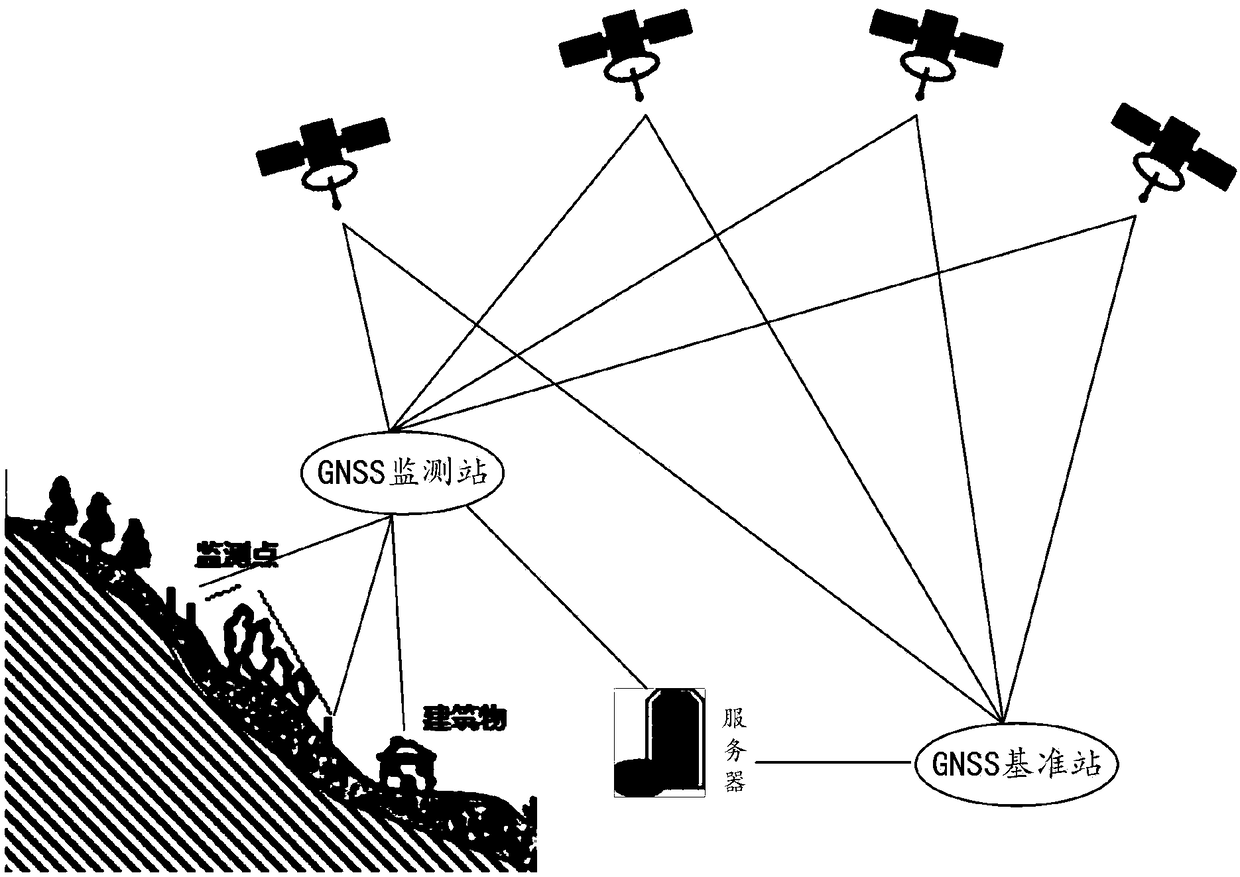
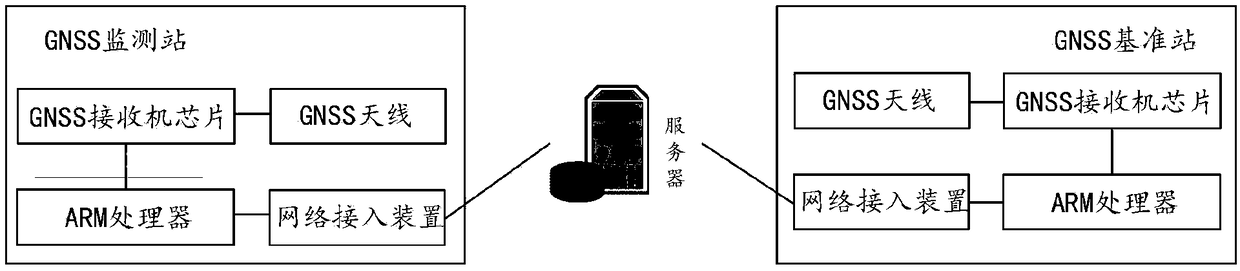
[0075] In this example, figure 1 Shown is a positioning system of a GNSS monitoring station. The positioning system includes: multiple satellites, GNSS reference stations and GNSS monitoring stations. The GNSS reference station is connected to the GNSS monitoring station through a communication link. The GNSS monitoring station is specifically used for: The first satellite carrier signal of each of the satellites.

[0076] Determine the first ephemeris data and the first observation data according to the first satellite carrier signal, determine the first satellite position of each satellite according to the first ephemeris data, and determine the first carrier phase corresponding to the first satellite position according to the first observation data Observations.

[0077] Receive the ephemeris time of each satellite and the differential correction parameters corresponding to the ephemeris time in real time through the communication link; determine the correction value of th...

Embodiment 2

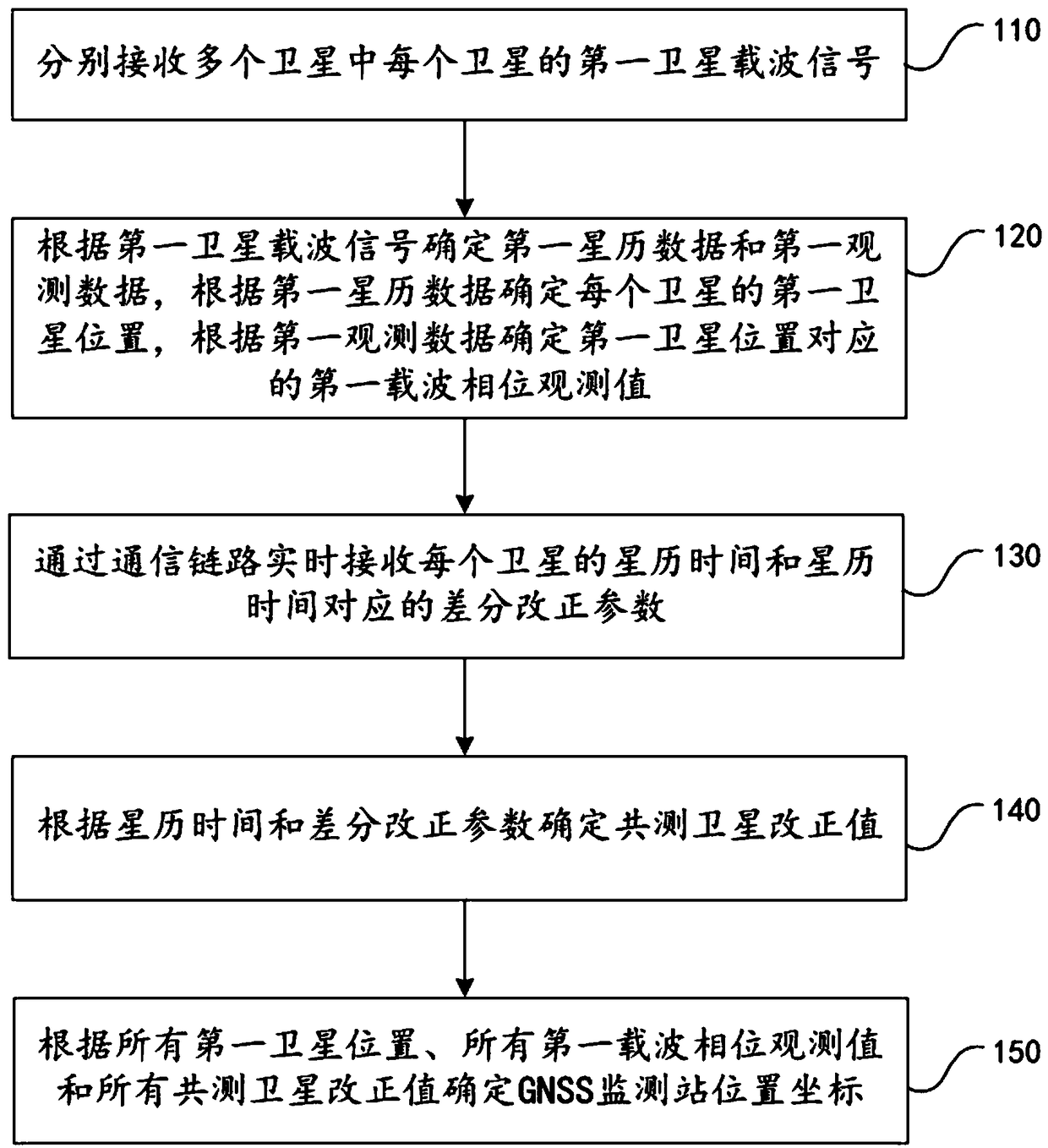
[0097] In this example, if image 3 Shown is a positioning method of a GNSS monitoring station, which is applied to a CNSS monitoring station. The CNSS monitoring station is connected with a CNSS reference station through a communication link. The positioning method includes the following specific steps:

[0098] Step 110. Respectively receive a first satellite carrier signal of each of the plurality of satellites.

[0099] Step 120: Determine the first ephemeris data and the first observation data according to the first satellite carrier signal, determine the first satellite position of each satellite according to the first ephemeris data, and determine the first satellite position corresponding to the first satellite position according to the first observation data A carrier phase observation.

[0100] Step 130, receiving the ephemeris time of each satellite and the differential correction parameters corresponding to the ephemeris time in real time through the communication...


PUM


Abstract

The invention relates to a positioning system and positioning method of a global navigation satellite system (GNSS) monitoring station. A GNSS reference station is connected with the GNSS monitoring station by a communication link. The positioning method comprises the steps of receiving a first satellite carrier signal of each satellite in a plurality of satellites; determining first ephemeris data and first observation data according to the first satellite carrier signal, determining a first satellite position of each satellite according to the first ephemeris data, and determining a first carrier phase observation value corresponding to the first satellite position according to the first observation data; receiving ephemeris time of each satellite and a differential correction parametercorresponding to the ephemeris in real time by the communication link; and determining a position coordinate of the GNSS monitoring station according to the positions of all first satellites, all first carrier phase observation values and all co-observation satellite correction values. According to the positioning system and the positioning method of the GNSS monitoring station, provided by the invention, the problem that monitoring satellites of the GNSS monitoring station and the GNSS reference station are not synchronous can be solved, and the positioning accuracy of the GNSS monitoring station is improved.

Description

technical field [0001] The invention relates to the technical field of GNSS positioning, in particular to a positioning system and a positioning method of a GNSS monitoring station. Background technique [0002] Based on the global navigation and positioning system (GNSS) to locate the position of the monitoring station, it is widely used to monitor the deformation of bridges, dams, high-rise buildings and other buildings and landslides, so as to make danger warnings based on the deformation and reduce personnel and property losses. [0003] At present, for the position positioning of monitoring stations, a positioning system of monitoring stations includes multiple satellites, at least one monitoring station and at least one reference station. Both monitoring stations and reference stations monitor each satellite to obtain satellite references. The satellite data and the satellite data of the reference station are used to calculate the carrier phase difference and the pseud...

Claims


Application Information

Patent Timeline
Patent Type & Authority Applications(China)
IPC IPC(8): G01S19/32G01S19/29G01S19/04G01S19/07G01S19/25G01S19/41
CPCG01S19/04G01S19/07G01S19/256G01S19/258G01S19/29G01S19/32G01S19/41
Inventor 蔡成林汪发胡佳李响曾武陵沈文波周晓燕
Owner GUILIN UNIV OF ELECTRONIC TECH
Why Eureka
Try Eureka