Unmanned aerial vehicle autonomous positioning method based on heterogeneous image matching and inertial navigation fusion

A heterogeneous image and inertial navigation technology, which is applied in surveying and mapping, navigation, navigation, navigation computing tools, etc., can solve the problem of reduced positioning accuracy of UAVs

Pending Publication Date: 2020-08-07
HUNAN AIRTOPS INTELLIGENT TECH CO LTD
View PDF0 Cites 10 Cited by
  • Summary
  • Abstract
  • Description
  • Claims
  • Application Information

AI Technical Summary

Problems solved by technology

However, when taking images with little texture or blurry images due to the rapid movement of the sensor, the positioning accuracy of the drone will be reduced.

Method used


Image

  • Unmanned aerial vehicle autonomous positioning method based on heterogeneous image matching and inertial navigation fusion
  • Unmanned aerial vehicle autonomous positioning method based on heterogeneous image matching and inertial navigation fusion
  • Unmanned aerial vehicle autonomous positioning method based on heterogeneous image matching and inertial navigation fusion

Examples


Embodiment 1

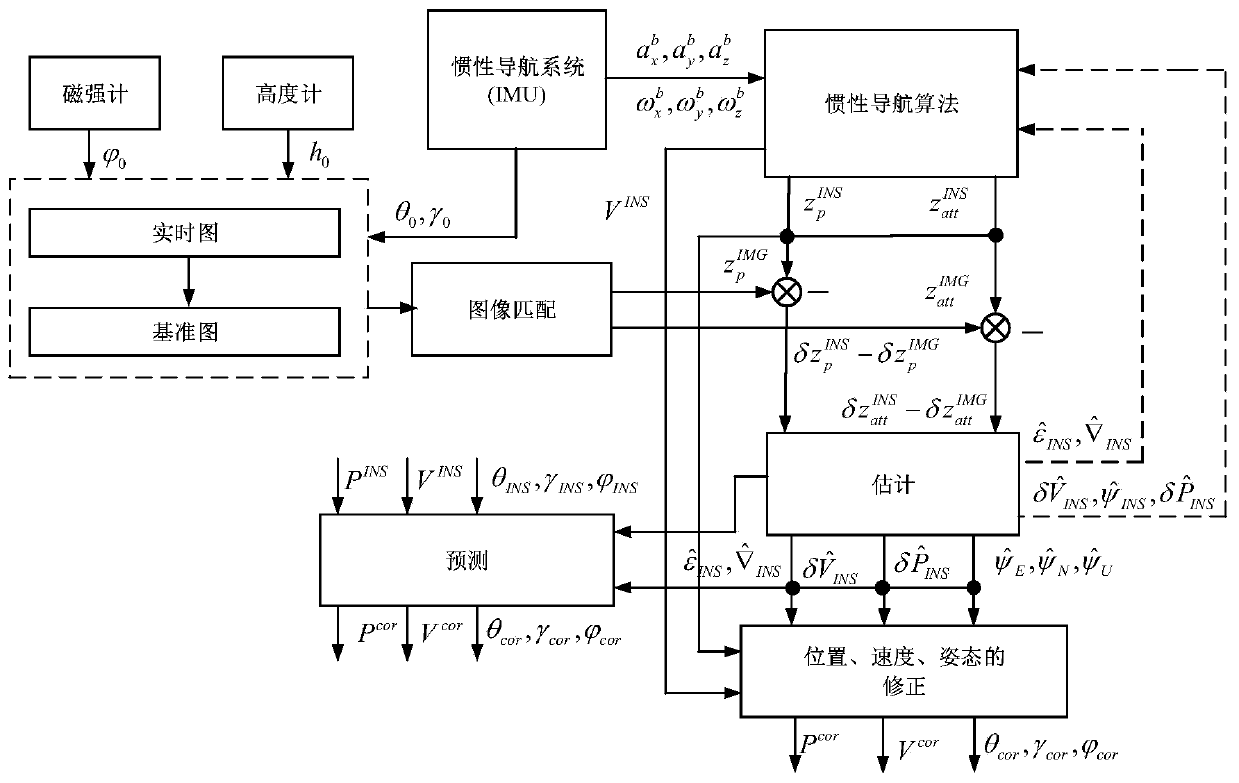
[0072] Embodiment 1 of the present invention provides a UAV autonomous positioning method based on heterogeneous image matching and inertial navigation fusion, comprising the following steps:

[0073] Step 1, use the inertial navigation system to provide the initial attitude θ of the UAV 0 ,γ 0 , the heading angle obtained by the magnetometer The altitude h obtained by the altimeter 0 Apply transformations to real-time graphs.

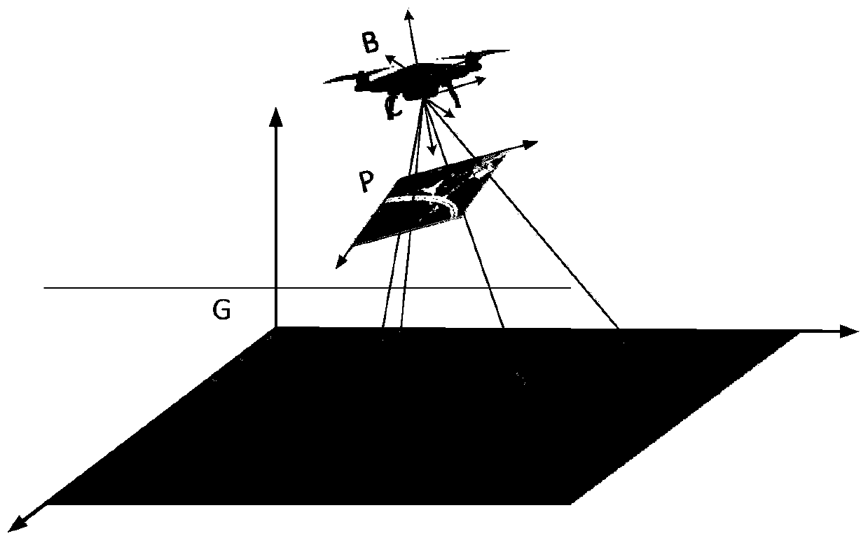
[0074] Step 2: Match the transformed real-time image with the reference image for heterogeneous images, and then obtain the precise position of the aircraft through PnP pose calculation and absolute attitude

[0075] Step 3, through the inertial navigation algorithm, the acceleration obtained by the accelerometer and the angular velocity obtained by the gyroscope Integrate to get the position of the inertial navigation and gesture

[0076] Step 4, use Kalman filter to establish the system equation of Kalman filter based on the error eq...

Embodiment 2

[0078] Embodiment 2 of the present invention provides a drone autonomous positioning algorithm based on heterogeneous image matching and inertial navigation fusion. The position and attitude of the drone can be obtained through the heterogeneous image matching algorithm, which can be used to correct the inertial navigation of the drone. error.

[0079] The design steps of the correction algorithm are as follows:

[0080] The UAV autonomous positioning scheme based on heterogeneous image matching and inertial navigation fusion mainly includes the following steps:

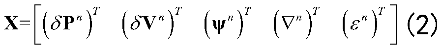
[0081] (1) The establishment of the state model of heterogeneous image matching / inertial navigation fusion positioning, as follows:

[0082]

[0083] In the formula, X(t) is the above-mentioned system state vector, W(t) is the system white noise, and the system noise F(t) and G(t) are obtained according to the error equation:

[0084]

[0085] Where: ψ n is the attitude error; δV n is the strapdown inertial...


PUM


Abstract

The embodiment of the invention provides an unmanned aerial vehicle autonomous positioning method based on heterogeneous image matching and inertial navigation fusion. The unmanned aerial vehicle autonomous positioning method comprises the following steps: step 1, transforming a real-time image by using initial attitudes [theta]0 and [gamma]0 of an unmanned aerial vehicle provided by an inertial navigation system and a height h0 obtained by a course angle altimeter obtained by a magnetometer; step 2, acquiring the accurate position and absolute attitude of the aircraft; step 3, acquiring the position and attitude of inertial navigation through an inertial navigation algorithm; and step 4, correcting the state of inertial navigation. According to the embodiment of the invention, long-time high-precision positioning of the aircraft can be realized.

Description

technical field [0001] The invention relates to an autonomous positioning method, in particular to an autonomous positioning method for an unmanned aerial vehicle based on heterogeneous image matching and inertial navigation fusion. Background technique [0002] In some complex environments, due to the limitations of the communication and perception capabilities of traditional sensors, UAVs cannot accurately perceive the surrounding environment and work normally. Therefore, high-performance autonomous navigation capabilities are of great significance to the development and application of UAVs. . UAV navigation can be seen as the process of planning to reach the target location safely and quickly, which mainly depends on the current environment and location. In order to successfully complete the scheduled task, the UAV must fully understand its state, including location, navigation speed, Heading direction as well as origin and destination positions, so position and position...

Claims


Application Information

Patent Timeline
Patent Type & Authority Applications(China)
IPC IPC(8): G01C21/20G01C21/16
CPCG01C21/165G01C21/20
Inventor 罗世彬任星宇
Owner HUNAN AIRTOPS INTELLIGENT TECH CO LTD
Why Eureka
Try Eureka