Rural house-ground integrated three-dimensional real estate management

A technology of real estate integration and management methods, applied in data processing applications, special data processing applications, image data processing, etc., can solve problems such as lack of three-dimensional data support, and achieve the effect of meeting the needs of real estate title management and registration

Active Publication Date: 2020-07-28
POWER CHINA KUNMING ENG CORP LTD
View PDF12 Cites 10 Cited by
  • Summary
  • Abstract
  • Description
  • Claims
  • Application Information

AI Technical Summary

Problems solved by technology

[0003] In order to solve the problem of the lack of support of 3D data in the rural property and land integrated confirmation

Method used


Image

  • Rural house-ground integrated three-dimensional real estate management
  • Rural house-ground integrated three-dimensional real estate management
  • Rural house-ground integrated three-dimensional real estate management

Examples


Embodiment 1

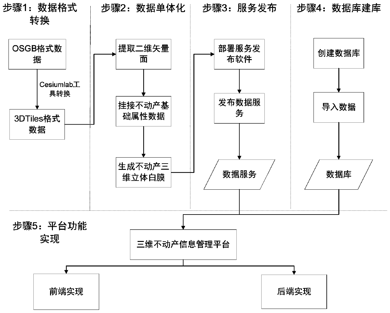
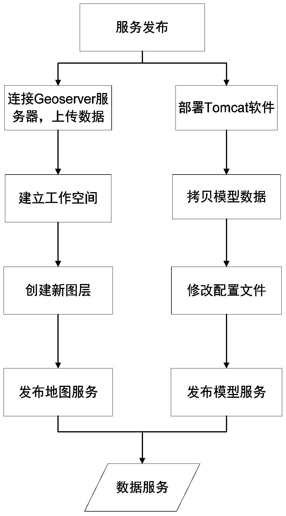
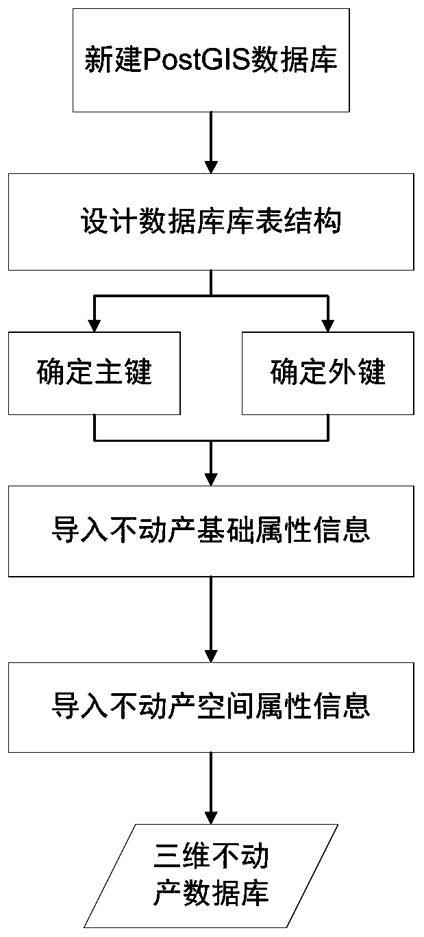
[0040] Embodiment 1: A specific embodiment of the present invention is described in detail with reference to the accompanying drawings. The three-dimensional real estate management method of rural real estate integration includes the following steps:

[0041]Step 1) Based on the existing oblique 3D model result data, convert the osgb format data to 3DTlies format data. Using the open source tool Cesiumlab, input the data in OSGB format, set the conversion parameters, and the tool processes the data according to the conversion algorithm to obtain the data conversion result. The output data in 3DTiles format should be a block and hierarchical data set, which is suitable for network data transmission and display on the Web side.

[0042] Step 2) The data obtained in step 1 is processed individually, and the dynamic singulation method is used to establish a three-dimensional white film divided by buildings, floors and households. Combined with the basic survey data of real estate,...


PUM


Abstract

The invention relates to the technical field of three-dimensional real estate management systems, and particularly relates to a rural house-ground integrated real estate management method based on aninclined three-dimensional model. According to the method, osgb format data of existing inclined three-dimensional model result data are converted into 3DTlies format data through an open source tool,then the 3DTlies data are subjected to single processing, and display of an inclined three-dimensional model accurate to a user is achieved; service management is performed on the topographic data, the two-dimensional vector plane data, the inclined three-dimensional model and the three-dimensional white film; and a three-dimensional real estate database is established, the real estate basic survey data is imported into the three-dimensional real estate database, and a front-end function and a rear-end function in the three-dimensional real estate information management platform are achieved.According to the method, the inclined three-dimensional model is introduced into real estate right management, the current situation of the real estate and surrounding ground objects can be observedand more truly reflected, and the requirements for real estate right management and registration of rural complex space rights are met.

Description

technical field [0001] The invention relates to the technical field of three-dimensional real estate management systems, in particular to a rural real estate integrated real estate management method based on an inclined three-dimensional model. Background technique [0002] The principle of the integration of housing and land means that the land use rights and the ownership of buildings and attachments such as houses on the land belong to the same subject. When real estate is transferred or mortgaged, the ownership of houses and land must be transferred and mortgaged at the same time. Confirmation of rights is the procedure of uniformly confirming and registering the right to use rural homesteads and collective construction land, as well as the buildings and structures on the ground. During the implementation of the rural real estate integrated ownership confirmation project, the staff were faced with a single result data format including cadastral maps, land maps, and real ...

Claims


Application Information

Patent Timeline
IPC IPC(8): G06T17/00G06F16/22G06F16/242G06Q50/16
CPCG06T17/00G06F16/2237G06F16/2282G06F16/2433G06F16/2428G06Q50/16G06T2210/04
Inventor 付航闻平吴小东李金华吴弦骏郑江杨林波吴荣光王莹
Owner POWER CHINA KUNMING ENG CORP LTD
Why Eureka
Try Eureka