Unmanned aerial vehicle fixed-point flight control system based on visual positioning

A flight control system and visual positioning technology, which is applied in the field of UAV fixed-point flight system, can solve the problems of reduced judgment accuracy, difficulty in guaranteeing imaging quality, inappropriate high-performance image processing system, etc., and achieve the effect of ensuring correctness

Active Publication Date: 2016-10-26
NORTH CHINA UNIVERSITY OF TECHNOLOGY
View PDF6 Cites 50 Cited by
  • Summary
  • Abstract
  • Description
  • Claims
  • Application Information

AI Technical Summary

Problems solved by technology

[0016] 3 Visual positioning technology is mostly used in static production and equipment environments. If a visual positioning system is to be assembled on a drone, the visual sensor will be in an unstable motion state, and the imaging quality is difficult to guarantee, resulting in a decline in judgment accuracy
In addition, considering the factor of battery life, the high-performance image processing system with too large volume and weight is not suitable for working on drones.

Method used


Image

  • Unmanned aerial vehicle fixed-point flight control system based on visual positioning
  • Unmanned aerial vehicle fixed-point flight control system based on visual positioning
  • Unmanned aerial vehicle fixed-point flight control system based on visual positioning

Examples


Embodiment Construction

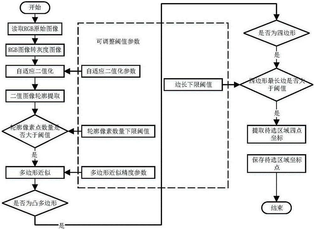
[0040] 1) Positioning logo design

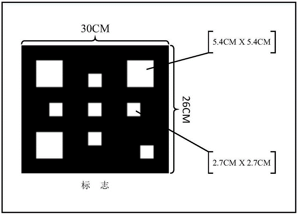
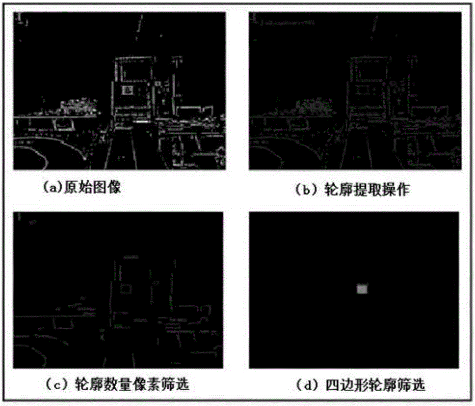
[0041] Whether the design of ground positioning marks is reasonable or not directly affects the accuracy of visual positioning and the speed of image processing. The design of the ground mark has fully considered the influence of environmental interference factors and the processing capacity of the onboard computer, which not only ensures the degree of differentiation from the environment, but also simplifies the design of the mark and increases the speed and accuracy of recognition. The position deviation and the rotation angle of the UAV relative to the ground positioning mark are analyzed according to the pattern.

[0042] figure 1 The actual size and shape of the ground markers are shown, considering the relationship between the field of view of the image sensor and the height, and the convenience of moving and placing the ground markers. The logo is a rectangular area with a width of 30 cm and a height of 26 cm. Two groups of white squa...


PUM


Abstract

The invention provides an unmanned aerial vehicle fixed-point flight control system based on visual positioning. The system comprises an UAV airborne module, a positioning marker, a ground monitoring module and a communication module. According to the system, through the cooperation with a visual processing algorithm, the UAV fixed-point flight is made by identification information, the disadvantages of low GPS fixed-point flight precision is made up, and the control system uses an open source operating system and a general UAV communication protocol and has good scalability and compatibility. The system can be applied to the UAV logistics, UAV monitoring and other directions.

Description

technical field [0001] The invention belongs to the field of machine vision / unmanned aerial vehicle positioning, and specifically relates to a system for locating and identifying artificial markers through a visual sensor, and controlling the fixed-point flight of an unmanned aerial vehicle by the identification information. Background technique [0002] With the continuous advancement of Internet technology, my country's e-commerce has developed rapidly, the market scale has expanded rapidly, and the logistics industry has also developed rapidly. However, many problems have been exposed behind the scenery, such as the untimely delivery of express delivery and the serious damage of goods delivered, etc. These problems also reflect the defects in the field of manual logistics. In order to make up for these shortcomings, major logistics companies have begun to think about how to reduce costs while ensuring service quality and meeting customer needs. As a result, the UAV deliv...

Claims


Application Information

Patent Timeline
Patent Type & Authority Applications(China)
IPC IPC(8): G05D1/12
CPCG05D1/12
Inventor 王庞伟于洪斌王力熊昌镇程冲
Owner NORTH CHINA UNIVERSITY OF TECHNOLOGY
Why Eureka
Try Eureka