Method and system for classification and recognition of urban construction land based on big data

A technology for urban construction, classification and recognition, applied in the field of big data processing, can solve the problems of low recognition speed and low recognition accuracy, and achieve the effect of improving the accuracy of classification and recognition, reducing the amount of data calculation, and improving the efficiency of classification and recognition

Active Publication Date: 2020-09-29
HENAN UNIVERSITY
View PDF5 Cites 0 Cited by
  • Summary
  • Abstract
  • Description
  • Claims
  • Application Information

AI Technical Summary

Problems solved by technology

[0004] The existing identification methods for urban construction land include manual surveying and mapping and remote sensing images. These two identification methods have low recognition speed and low recognition accuracy.

Method used


Image

  • Method and system for classification and recognition of urban construction land based on big data
  • Method and system for classification and recognition of urban construction land based on big data
  • Method and system for classification and recognition of urban construction land based on big data

Examples


Embodiment 1

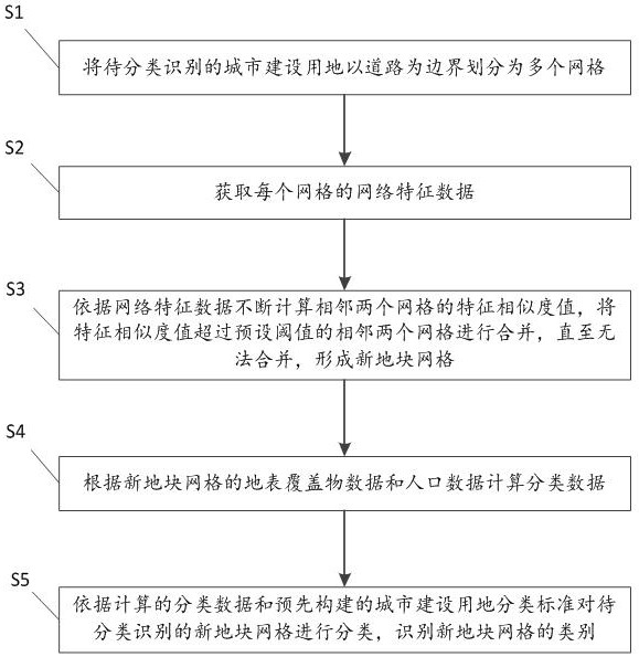
[0051] Such as figure 1 As shown, the application provides a method for classifying and identifying urban construction land based on big data, which method includes the following steps:

[0052]In step S1, the urban construction land to be classified and identified is divided into multiple grids with roads as boundaries.

[0053] Step S2, acquiring network characteristic data of each grid.

[0054] Obtaining network characteristic data in each grid includes: obtaining land cover data and population data.

[0055] Obtain the land cover data in the grid according to the GIS geographic information system or extract the land cover data from the Baidu open platform according to the keyword extraction method, and obtain the population data in the grid according to the registered addresses of the resident population and floating population.

[0056] Among them, the land cover data includes the types of land cover and the corresponding quantity and land area of ​​each type of land c...

Embodiment 2

[0092] Such as Figure 4 As shown, the present application also provides a big data-based urban construction land classification and recognition system 100, which includes:

[0093] The grid division module 10 is used to divide the urban construction land to be classified and identified into a plurality of grids with the road as the boundary;

[0094] Obtaining module 20, for obtaining the network feature data of each grid;

[0095] The similar grid merging module 30 is used to continuously calculate the feature similarity value of two adjacent grids according to the network feature data, and merge two adjacent grids whose feature similarity value exceeds a preset threshold until it cannot be merged, Form a new plot grid;

[0096] Calculation module 40, for calculating classification data according to the ground cover data and population data of new plot grid;

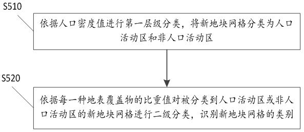
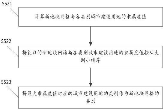
[0097] The identifying category module 50 is configured to classify the new plot grids to be classified and ident...


PUM


Abstract

This application provides a method and system for classifying and identifying urban construction land based on big data. The method includes: dividing the urban construction land to be classified and identified into multiple grids with roads as boundaries; obtaining network characteristic data of each grid ;Continuously calculate the feature similarity value of two adjacent grids according to the network feature data, and merge the two adjacent grids whose feature similarity value exceeds the preset threshold until they cannot be merged to form a new plot grid; The land cover data and population data of the new plot grids are used to calculate the classification data; the new plot grids to be classified and identified are classified according to the calculated classification data and the pre-built urban construction land classification standards, and the new plot grids are identified. category. The application classifies and identifies the types of urban construction land, which improves the efficiency and classification accuracy of urban construction land classification and identification.

Description

technical field [0001] The present application relates to the field of big data processing technology, in particular to a method and system for classifying and identifying urban construction land based on big data. Background technique [0002] With the advancement of my country's urbanization process, the rapid expansion of urban construction land has had an important impact on the city's society, economy, and environment. How to accurately and efficiently identify the types of urban construction land is crucial for urban-related research. important. [0003] Land for urban construction refers to residential land, land for public management and public services, land for commercial service facilities, industrial land, land for logistics and warehousing, land for transportation facilities, land for public facilities, and green land in the town where the people's government of the city and county is located. [0004] Existing identification methods for urban construction land ...

Claims


Application Information

Patent Timeline
Patent Type & Authority Patents(China)
IPC IPC(8): G06K9/62G06Q50/26
CPCG06Q50/26G06F18/22G06F18/24
Inventor 张鹏岩周志民秦明周李颜颜杨丹耿文亮
Owner HENAN UNIVERSITY
Why Eureka
Try Eureka