Satellite intelligent data transmission method based on remote sensing state estimation and system thereof

A technology of state estimation and remote sensing data, applied in the field of satellite data transmission system, it can solve the problems of no explanation or report found, and data not yet collected, so as to improve the quality and efficiency, improve the transmission ability of remote sensing data, and achieve good engineering application value. Effect

Active Publication Date: 2020-07-31
SHANGHAI SATELLITE ENG INST
View PDF11 Cites 8 Cited by
  • Summary
  • Abstract
  • Description
  • Claims
  • Application Information

AI Technical Summary

Problems solved by technology

At present, no description or report of similar related technologies has been found, and similar materials at home and abroad have not been collected yet.

Method used


Image

  • Satellite intelligent data transmission method based on remote sensing state estimation and system thereof
  • Satellite intelligent data transmission method based on remote sensing state estimation and system thereof
  • Satellite intelligent data transmission method based on remote sensing state estimation and system thereof

Examples


Embodiment Construction

[0054] The present invention will be described in detail below in conjunction with specific embodiments. The following examples will help those skilled in the art to further understand the present invention, but do not limit the present invention in any form. It should be noted that those skilled in the art can make several changes and improvements without departing from the concept of the present invention. These all belong to the protection scope of the present invention.

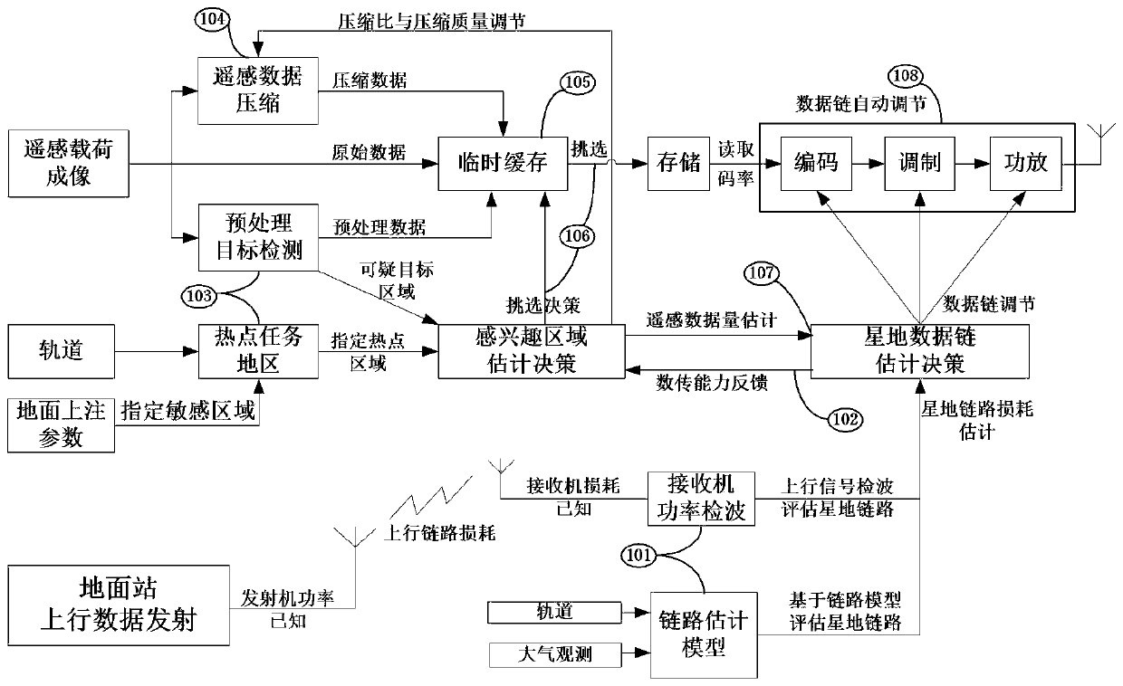
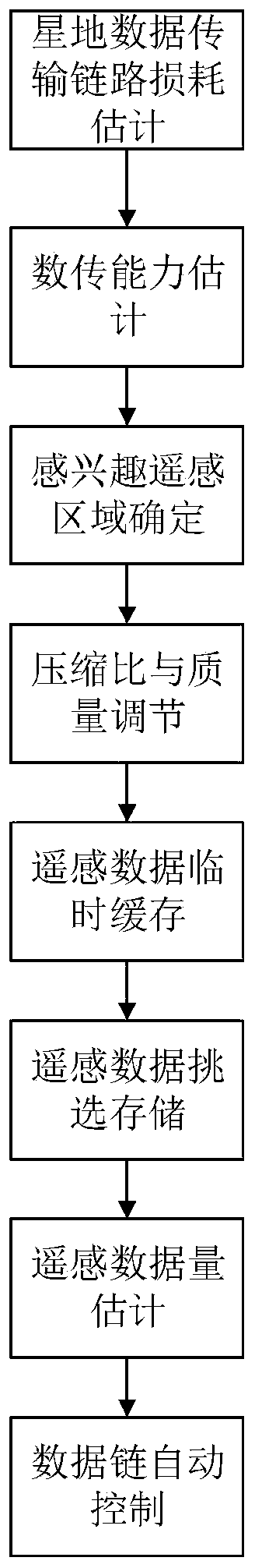
[0055] A kind of satellite intelligent data transmission method based on remote sensing state estimation provided by the present invention comprises: such as Figure 1-2 as shown,

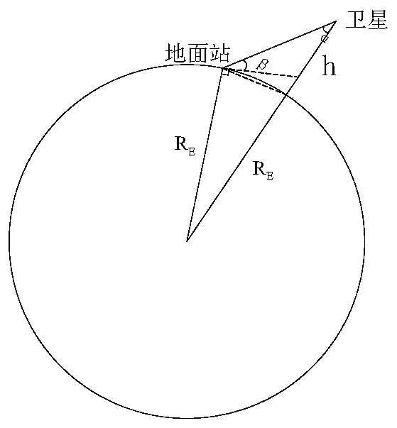
[0056] Step M1: According to the uplink power detection and link model estimation, estimate the loss of the satellite-to-ground data transmission link in real time, and estimate the data transmission capacity of the satellite-to-ground channel;

[0057] Step M2: Calculate and obtain the maximum data transmission capacity of...


PUM


Abstract

The invention provides a satellite intelligent data transmission method based on remote sensing state estimation and a system thereof, and the method comprises the steps: estimating the satellite-ground data transmission link loss in real time according to uplink power detection and link model estimation; calculating the maximum data transmission capability of data transmission according to the satellite-ground data transmission link loss; identifying an interested remote sensing region through preprocessing target detection and hot spot region designation; adjusting a remote sensing data compression ratio and compression quality according to the obtained maximum data transmission capability and the data volume of the interested remote sensing area; caching the preprocessed target detection data, the original remote sensing data and the compressed remote sensing data, and selecting and storing data information needing to be downloaded according to the maximum data transmission capability and the interested remote sensing area data volume; reading to-be-downloaded data, and adjusting a satellite data transmission link according to the to-be-downloaded data volume and the transmission link loss. The code rate, the coding mode, the modulation mode and the transmitting power of the remote sensing data link are optimized, and the remote sensing data transmission capacity is improved.

Description

technical field [0001] The invention relates to a satellite data transmission system, in particular to a satellite intelligent data transmission method and system based on remote sensing state estimation, which is applied to satellite data transmission design. Background technique [0002] The satellite data transmission system is used to transmit satellite remote sensing data, and the effectiveness of the transmission directly affects the mission operation of the satellite. Traditional data transmission adopts a fixed mode design, all remote sensing data is downloaded, and the transmission is not optimized for the area of ​​interest. Therefore, the amount of data to be stored and transmitted is large, and the storage and transmission resources of the satellite are limited, which restricts the working period of the remote sensing load. The data link adopts a fixed design, which cannot be intelligently adjusted for the status of the satellite-ground link and the amount of rem...

Claims


Application Information

Patent Timeline
Patent Type & Authority Applications(China)
IPC IPC(8): H04B17/318H04B17/391H04B7/185
CPCH04B17/318H04B17/3911H04B7/18539
Inventor 杨同智刘廷玉周汝志盛开明赵美玲
Owner SHANGHAI SATELLITE ENG INST
Why Eureka
Try Eureka