Fishery information service method based on positions

An information service and fishery technology, applied in measuring devices, satellite radio beacon positioning systems, traffic control systems, etc., can solve problems such as inability to accurately warn of meteorological disasters, achieve changes in limitations, improve safety, and be highly targeted Effect

Inactive Publication Date: 2020-08-04
舟山国家远洋渔业基地科技发展有限公司
View PDF5 Cites 2 Cited by
  • Summary
  • Abstract
  • Description
  • Claims
  • Application Information

AI Technical Summary

Problems solved by technology

At present, the meteorological monitoring of waterways is mainly based on the comprehensive analysis and prediction of weather dynamics by meteorological satellites and large-scale we...

Method used


Image

  • Fishery information service method based on positions

Examples


Embodiment Construction

[0021] The following will clearly and completely describe the technical solutions in the embodiments of the present invention with reference to the accompanying drawings in the embodiments of the present invention. Obviously, the described embodiments are only some, not all, embodiments of the present invention. All other embodiments obtained by persons of ordinary skill in the art based on the embodiments of the present invention belong to the protection scope of the present invention.

[0022] According to an embodiment of the present invention, a location-based fishery information service method is provided.

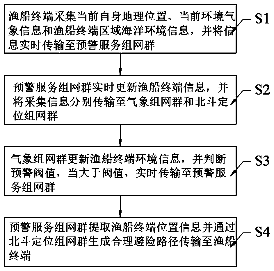
[0023] Such as figure 1 As shown, the location-based fishery information service method according to the embodiment of the present invention includes the following steps:

[0024] Step S1, the fishing boat terminal collects its current geographical location, current environmental meteorological information, and marine environment information in the fishing boat termi...


PUM


Abstract

The invention discloses a fishery information service method based on a position, and the method comprises the following steps: S1, enabling a fishing boat terminal to collect the current geographic position, current environment meteorological information and fishing boat terminal region marine environment information, and transmitting the information to an early warning service networking group in real time; and S2, enabling the early warning service networking group to update the fishing boat terminal information in real time, and transmit the acquired information to the meteorological networking group and the Beidou positioning networking group. A fishing boat terminal collects a current geographic position, current environment meteorological information and fishing boat terminal area marine environment information; marine meteorological information and fishing boat terminal position information are shared in real time; collision of the fishing boat terminal due to severe weather and early prevention and timely avoidance of severe difference under the severe weather are effectively avoided, the sailing safety is improved, limitations of existing marine fishery information services are effectively changed, and the marine fishery information service system is high in pertinence and wide in application range.

Description

technical field [0001] The invention relates to the technical field of early warning systems, in particular to a location-based fishery information service method. Background technique [0002] Marine fishery is an important component industry of the marine economy. The development of marine fishery resources is a production activity that relies on marine space. The marine space environment and fishery resources are the necessary platforms and carriers for these industrial activities. In marine fishery production and management, marine fishery information services have become an important guarantee for the realization of marine fishery production and management planning goals. Relevant researches and applications have been carried out at home and abroad to provide information services for marine fisheries using high-tech such as computer network communications and satellite applications. Most of them focus on using marine environmental information obtained by satellite remot...

Claims


Application Information

Patent Timeline
IPC IPC(8): G06Q50/02G08G3/02G01D21/02G01S19/42
CPCG06Q50/02G08G3/02G01S19/42G01D21/02
Inventor 史宇
Owner 舟山国家远洋渔业基地科技发展有限公司
Why Eureka
Try Eureka