Orchard inter-row navigation line extraction method based on 3D Lidar

An extraction method and a technology of navigation lines, which are applied in the fields of electromagnetic wave reradiation, radio wave measurement system, image data processing, etc., can solve problems such as error-prone, large amount of image processing data, and large environmental interference, and achieve low environmental interference , high real-time performance and low computational load

Active Publication Date: 2020-08-14
CHINA AGRI UNIV
View PDF5 Cites 7 Cited by
  • Summary
  • Abstract
  • Description
  • Claims
  • Application Information

AI Technical Summary

Problems solved by technology

[0005] At present, domestic and foreign research on the extraction of orchard inter-row navigation lines is mainly based on image processing and two-dimensional laser radar. The

Method used


Image

  • Orchard inter-row navigation line extraction method based on 3D Lidar
  • Orchard inter-row navigation line extraction method based on 3D Lidar
  • Orchard inter-row navigation line extraction method based on 3D Lidar

Examples


Embodiment Construction

[0044] The present invention will be further described below in conjunction with the accompanying drawings and embodiments.

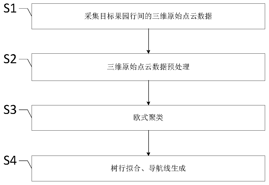
[0045] Such as figure 1 As shown, a kind of 3D Lidar-based orchard row navigation line extraction method of the present invention comprises the steps:

[0046] S1. Collect the three-dimensional original point cloud data between the rows of the target orchard;

[0047] The 3D original point cloud data between rows of the target orchard is collected by 3D Lidar, and the 3D coordinate system OXYZ is constructed.

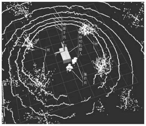
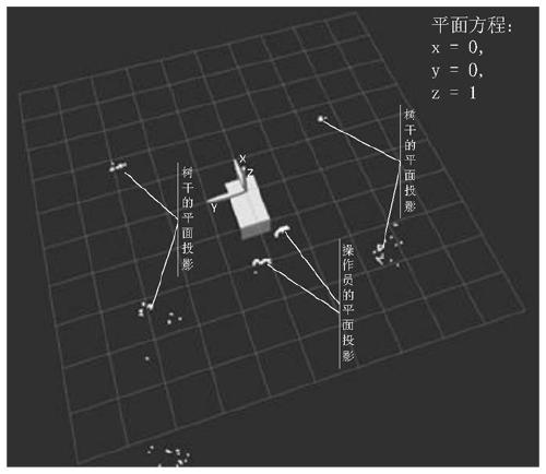
[0048] Such as figure 2 As shown, the block in the figure is the mobile robot. The geometric center of the mobile robot and the geometric center of the 3D Lidar are located on the Z axis perpendicular to the horizontal plane. The geometric center of the 3D Lidar is the origin O of the three-dimensional Cartesian coordinate system OXYZ. The movement of the mobile robot The direction is the X-axis, and the Y-axis is perpendicular to the X-axis ...


PUM


Abstract

The invention belongs to the technical field of three-dimensional point cloud processing, and particularly relates to an orchard inter-line navigation line extraction method based on 3D Lidar. The method is suitable for automatic walking of an operation machine tool. The method comprises the following steps: S1, collecting three-dimensional original point cloud data between lines of a target orchard; s2, preprocessing the three-dimensional original point cloud data; s3, performing Euclidean clustering; and S4, tree line fitting and navigation line generation. According to the method, the midpoint of the three-dimensional projection of the trunk is used for replacing the position of the trunk, trunk positioning between orchard lines is achieved, then the navigation line is extracted, and the method has the advantages of being small in operand, high in real-time performance, small in environmental interference, high in precision, high in robustness and the like.

Description

technical field [0001] The invention belongs to the technical field of three-dimensional point cloud processing, and in particular relates to a 3D Lidar-based orchard inter-row navigation line extraction method suitable for automatic walking of work tools. Background technique [0002] Orchard automatic navigation technology is the core to achieve human-machine separation and unmanned refined orchard management, and it is also a key technology for the development of smart agriculture in the future. At present, orchard automatic navigation technology mainly includes GNSS navigation, machine vision navigation, sound source navigation, multi-sensor fusion navigation and laser navigation according to environmental perception classification. For GNSS navigation, the ground walking satellite signal receiver is easily blocked by the growing and changing canopy branches and leaves during the fruit tree production period and loses positioning signals; for machine vision navigation, i...

Claims


Application Information

Patent Timeline
IPC IPC(8): G06K9/62G06T7/73G01S17/894
CPCG06T7/73G01S17/894G06F18/23
Inventor 何雄奎刘伟洪刘亚佳王志翀齐鹏韩冷
Owner CHINA AGRI UNIV
Why Eureka
Try Eureka