Global navigation auxiliary method based on unmanned aerial vehicle shooting and semantic segmentation

A technology of semantic segmentation and navigation assistance, applied in navigation, surveying and mapping and navigation, navigation computing tools, etc., can solve problems such as low-speed automatic driving that cannot meet the off-road navigation requirements of engineering vehicles, impossible coverage by map providers, and complex terrain in outdoor venues, etc.

Active Publication Date: 2020-08-18
JIANGSU GAIYA ENVIRONMENTAL SCI & TECH CO LTD
View PDF13 Cites 6 Cited by
  • Summary
  • Abstract
  • Description
  • Claims
  • Application Information

AI Technical Summary

Problems solved by technology

[0002] The current development of unmanned driving technology is in full swing, but it largely relies on the existing satellite maps and high-precision road maps for global path planning, but there is no mature technology for the path of outdoor venues without roads. , that is, the off-road navigation requirements of engineering vehicles and their low-speed automatic driving cannot be realized. On the one hand, the outdoor off-road navigation area is too large, and it is impossible for the map provider to cover every inch of land. On the other hand, the outdoor site has complex terrain and obstacles. There are a lot of numbers and types, and there is no general way to effectively avoid them. Finally, the special nature of outdoor off-road equipment leads to special requirements for the required paths

Method used


Image

  • Global navigation auxiliary method based on unmanned aerial vehicle shooting and semantic segmentation
  • Global navigation auxiliary method based on unmanned aerial vehicle shooting and semantic segmentation
  • Global navigation auxiliary method based on unmanned aerial vehicle shooting and semantic segmentation

Examples


Embodiment

[0039] The present invention will be further described in detail below in conjunction with the drawings.

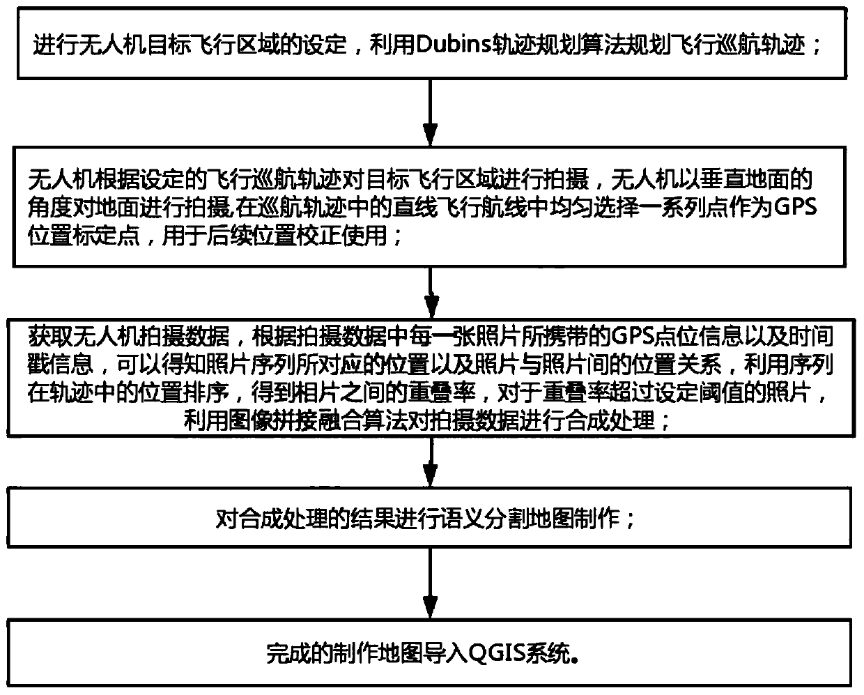
[0040] A global navigation assistance method based on UAV shooting and semantic segmentation, such as figure 1 As shown, the package sets the target flight area of ​​the UAV, and uses the Dubins trajectory planning algorithm to plan the flight cruise trajectory;

[0041] The drone shoots the target flight area according to the set flight cruise trajectory. The drone shoots the ground at an angle perpendicular to the ground, and evenly selects a series of points in the straight flight path in the cruise trajectory as GPS position calibration points. Used for subsequent position correction;

[0042] After the drone returns home, upload the information in the memory card it carries to the server to obtain the drone shooting data. According to the GPS point information and time stamp information carried by each photo in the shooting data, the photos can be known The position corre...


PUM


Abstract

The invention discloses a global navigation auxiliary method based on unmanned aerial vehicle shooting and semantic segmentation, and the method comprises the following steps: setting a target flightarea of an unmanned aerial vehicle, and planning a flight cruising trajectory by using a Dubins trajectory planning algorithm; enabling the unmanned aerial vehicle to shoot a target flight area according to the set flight cruising trajectory, enabling the unmanned aerial vehicle to shoot the ground at an angle perpendicular to the ground, and uniformly selecting a series of points from a linear flight route in the cruising trajectory to serve as GPS position calibration points; according to the GPS point location information and the timestamp information carried by each photo in the shooting data, performing synthesis processing on the shooting data by utilizing an image splicing fusion algorithm; performing semantic segmentation map making on the result of the synthesis processing; and importing the completed map into a QGIS system. According to the invention, the neural network model is utilized to construct the required map, and the special requirement of the outdoor cross-country equipment for the required path can be provided for the special property of the outdoor cross-country equipment.

Description

Technical field [0001] The invention relates to the field of outdoor global navigation, and more specifically, it relates to a global navigation assistance method based on drone shooting and semantic segmentation. Background technique [0002] The current development of unmanned driving technology is booming, but to a large extent it relies on existing satellite maps and high-precision road maps for global path planning, but there is no mature technology that can be used for the path of outdoor venues without roads. , That is, it is impossible to realize the off-road navigation requirements of construction vehicles and its low-speed automatic driving. On the one hand, the outdoor off-road navigation area is too large, and the map provider cannot cover every inch of land. On the other hand, the outdoor site is complex and obstacles. There are quite a lot of numbers and types, and there is no universal way to effectively avoid them. Finally, the special nature of outdoor off-road e...

Claims


Application Information

Patent Timeline
Patent Type & Authority Applications(China)
IPC IPC(8): G01C21/00G01C21/20G01S19/45G06F16/29G06T3/40G06T5/50G06T11/20
CPCG01C21/005G01C21/20G01S19/45G06T3/4038G06T5/50G06T11/206G06F16/29G06T2207/20081G06T2207/20084G06T2207/20221
Inventor 祖浩杰汪筱亮
Owner JIANGSU GAIYA ENVIRONMENTAL SCI & TECH CO LTD
Why Eureka
Try Eureka