Spatial layering method and device based on remote sensing data products with different spatial resolutions

A technology of spatial resolution and remote sensing data, applied in the direction of instruments, scene recognition, calculation, etc., can solve the problems of ignoring the differences of ground objects, increasing the uncertainty of remote sensing classification and accuracy evaluation, affecting the results of remote sensing classification and accuracy evaluation, etc. Achieve the effect of ensuring accuracy and reliability and reducing uncertainty

Active Publication Date: 2022-03-18
北京市农林科学院信息技术研究中心
View PDF2 Cites 0 Cited by
  • Summary
  • Abstract
  • Description
  • Claims
  • Application Information

AI Technical Summary

Problems solved by technology

[0004] At present, the spatial stratification in the field of remote sensing is basically the stratification of land use and land cover types. However, this spatial stratification method ignores the differences in different spatial resolutions of ground objects, and then spatial stratification will affect remote sensing. Classification and accuracy evaluation results, increasing the uncertainty of remote sensing classification and accuracy evaluation

Method used


Image

  • Spatial layering method and device based on remote sensing data products with different spatial resolutions
  • Spatial layering method and device based on remote sensing data products with different spatial resolutions
  • Spatial layering method and device based on remote sensing data products with different spatial resolutions

Examples


Embodiment Construction

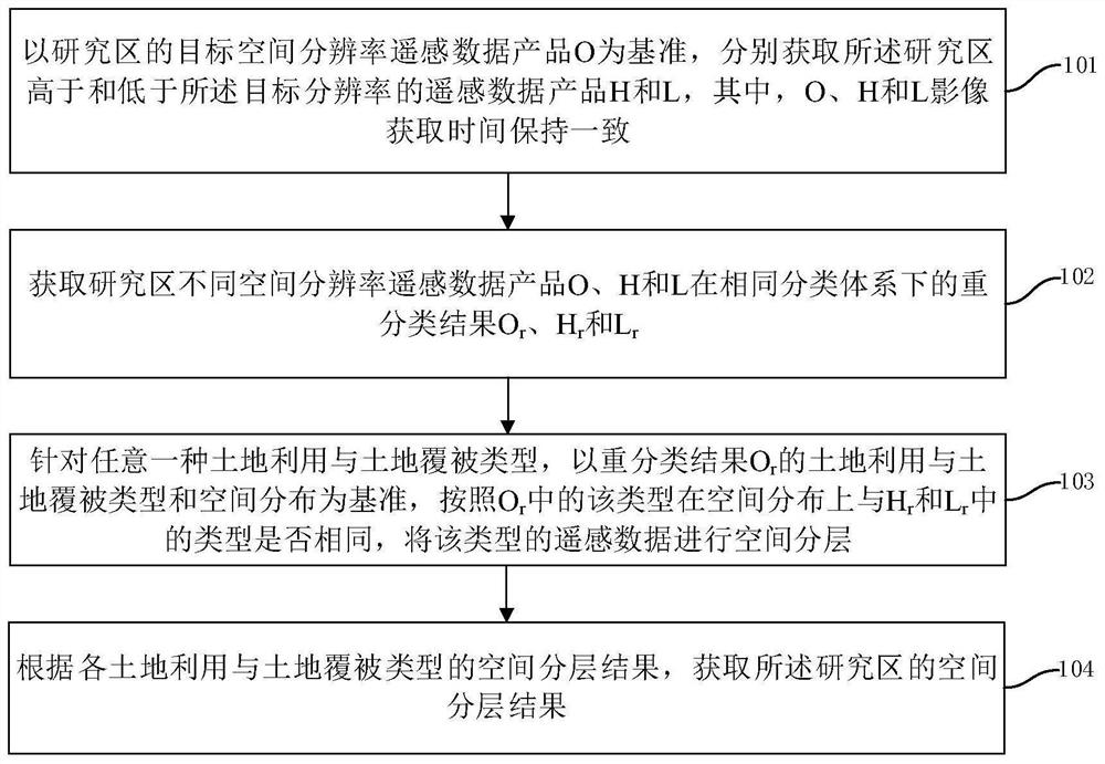
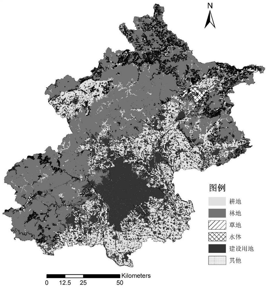
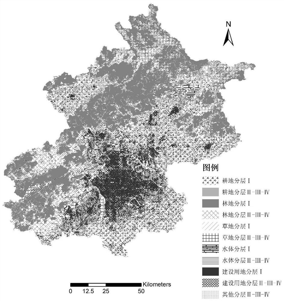
[0048] The specific embodiments of the present invention will be further described below in conjunction with the accompanying drawings. The following examples are only used to illustrate the technical solution of the present invention more clearly, but not to limit the protection scope of the present invention.

[0049] In recent years, with the continuous development and improvement of remote sensing technology, many global or regional remote sensing data products have emerged at home and abroad, and the spatial resolution is mostly between 10m-1km. These data products are applied in ecological environment monitoring, climate change, agricultural resource utilization etc. Due to the complexity, heterogeneity, and fragmentation of regional land surface landscapes, there are significant differences in research on different scales and fields based on remote sensing data products with different spatial resolutions. How to conduct reasonable and effective spatial analysis for diff...


PUM


Abstract

The invention discloses a spatial layering method and device based on remote sensing data products with different spatial resolutions, which includes: taking the target spatial resolution remote sensing data product O of the research area as a reference, obtaining the data higher and lower than the target resolution respectively Remote sensing data products H and L; obtain the reclassification results of O, H and L under the same classification system O r 、H r and L r ; For any land use and land cover type, the reclassification result O r The land use and land cover type and spatial distribution are used as the benchmark, according to O r The type in the spatial distribution is the same as H r and L r Whether the types in are the same to spatially stratify the type of remote sensing data. The present invention takes into account the differences reflected in different spatial resolutions of ground objects, and better demonstrates the heterogeneity of spatial layering of ground objects, so that the spatial layering scheme is more reasonable and effective, and at the same time reduces the inconsistencies caused by layering. Certainty, which can guarantee the accuracy and reliability of subsequent data analysis.

Description

technical field [0001] The invention relates to the technical field of remote sensing classification and quantitative interpretation, in particular to a spatial layering method and device based on remote sensing data products with different spatial resolutions. Background technique [0002] In recent years, with the continuous development and improvement of remote sensing technology, many global or regional remote sensing data products have emerged at home and abroad, and the spatial resolution is mostly between 10m-1km. These data products are applied in ecological environment monitoring, climate change, agricultural resource utilization etc. Due to the complexity, heterogeneity, and fragmentation of regional land surface landscapes, there are significant differences in research on different scales and fields based on remote sensing data products with different spatial resolutions. How to conduct reasonable and effective spatial analysis for different regions and research p...

Claims


Application Information

Patent Timeline
Patent Type & Authority Patents(China)
IPC IPC(8): G06V20/10G06V10/764G06K9/62
CPCG06V20/13G06F18/24
Inventor 董士伟潘瑜春刘玉郝星耀周艳兵李淑华郜允兵
Owner 北京市农林科学院信息技术研究中心
Why Eureka
Try Eureka