Eureka AIR delivers breakthrough ideas for toughest innovation challenges, trusted by R&D personnel around the world.

Remote sensing image road extraction method based on D-LinkNet

A road extraction and remote sensing image technology, applied in the field of remote sensing image processing, can solve problems such as weak anti-interference ability, insufficient road, adhesion, etc., to avoid degradation problems, strengthen learning, and reduce interference.

Active Publication Date: 2020-10-13
HARBIN ENG UNIV
View PDF7 Cites 11 Cited by
  • Summary
  • Abstract
  • Description
  • Claims
  • Application Information

AI Technical Summary

Problems solved by technology

However, when the model is affected by complex terrain, the extracted roads are still not sufficient, and it cannot respond sensitively to changes in road width.
[0006] The road extraction method based on edge features can effectively extract simple road information, but its anti-interference ability is not strong; when there is less information similar to the road in the image, the extraction effect of the object-based road extraction method is good, but in other When the ground features are too similar to the road and the space is closely adjacent, most of these methods have adhesion phenomenon. For a few methods that improve this problem, the design of the extraction process is too complicated or the extraction scale is difficult to grasp, which makes road extraction difficult. Bottleneck; the road extraction method based on deep learning has a strong learning ability, which can well solve the problems of changing road types, complex and diverse backgrounds, and similar road and non-road features. However, such methods still have insufficient road extraction, It is easy to lose spatial information or not universal enough for scenes with large changes

Method used


Image

  • Remote sensing image road extraction method based on D-LinkNet
  • Remote sensing image road extraction method based on D-LinkNet
  • Remote sensing image road extraction method based on D-LinkNet

Examples


Embodiment Construction

[0035] The present invention will be further described in detail below in conjunction with the accompanying drawings and specific embodiments.

[0036] The invention relates to the field of remote sensing image processing, in particular to a remote sensing image road extraction algorithm based on a semantic segmentation network.

[0037] In view of the deficiencies in the prior art, the purpose of the invention or the technical problem to be solved of the present invention are:

[0038] 1. Realize the feature extraction of remote sensing images and the automatic segmentation of roads;

[0039] 2. Avoid network degradation problems while enhancing the extraction of road features;

[0040] 3. To solve the problem that the road part in the remote sensing image occupies a small proportion of the frame, improve the accuracy of road extraction;

[0041] 4. Aiming at the problem that roads are too similar to rivers, railways and other ground features, avoid the phenomenon of mixing...


PUM


Abstract

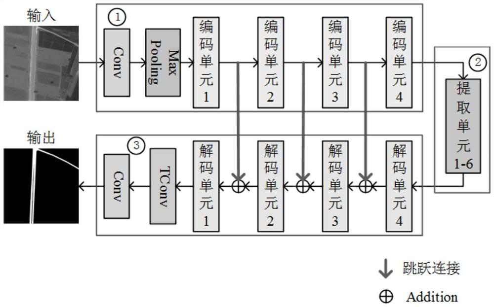
The invention provides a remote sensing image road extraction method based on D-LinkNet, and the method comprises the following steps: S1, inputting a feature map into a D-LinkNet network, and completing the processing in an encoder sub-network based on a residual network and transfer learning; S2, inputting the feature map output in the step S1 into a feature extraction sub-network based on an expansion convolution and convolution block attention module for feature extraction; S3, enabling the feature map obtained after processing of the first two sub-networks to enter a decoder sub-network based on transposed convolution to realize image recovery. According to the invention, downsampling can be carried out on the road features in the remote sensing image, the problem of network degradation is well avoided, and the extraction of the road features is enhanced; the receptive field can be amplified by using the expansion convolution, the road characteristics in a larger range are sensedand the characteristics are extracted without increasing down-sampling, and the problem that the proportion of the road part in the remote sensing image is too small can be well solved.

Description

technical field [0001] The invention relates to a method for extracting a road from a remote sensing image, in particular to a method for extracting a road from a remote sensing image based on D-LinkNet, and belongs to the field of remote sensing image processing. Background technique [0002] Remote Sensing (RS) refers to the non-contact, long-distance real-time collection of earth resources and other targets through remote sensors or sensors, and then extracts, analyzes and processes relevant data information. In recent decades, many scholars at home and abroad have carried out extensive and profound research on the complex road information in remote sensing images, and have proposed various road extraction algorithms one after another. At present, according to the three relatively mature and commonly used strategies, the road extraction methods of remote sensing images at home and abroad can be divided into three categories, namely, the three road extraction methods based...

Claims


Application Information

Patent Timeline
IPC IPC(8): G06K9/00G06K9/34G06K9/46G06N3/04G06N3/08
CPCG06N3/08G06V20/182G06V10/26G06V10/40G06N3/045
Inventor 兰海燕李京桦孙建国孙鹤玲
Owner HARBIN ENG UNIV
Why Eureka
Eureka Blog
Learn More