Airborne UWB positioning method for unmanned aerial vehicles

A positioning method and UAV technology, applied in the field of electronics and information, can solve the problems of limited flight space, time-consuming and laborious, and inconvenient to carry the device.

Pending Publication Date: 2020-10-27
CIVIL AVIATION UNIV OF CHINA
View PDF0 Cites 1 Cited by
  • Summary
  • Abstract
  • Description
  • Claims
  • Application Information

AI Technical Summary

Problems solved by technology

[0006] The purpose of the present invention is to provide a UWB airborne UWB positioning method for unmanned aerial vehicles to solve the problem that anchor points need to be arranged before positioning pro

Method used


Image

  • Airborne UWB positioning method for unmanned aerial vehicles
  • Airborne UWB positioning method for unmanned aerial vehicles
  • Airborne UWB positioning method for unmanned aerial vehicles

Examples


Embodiment Construction

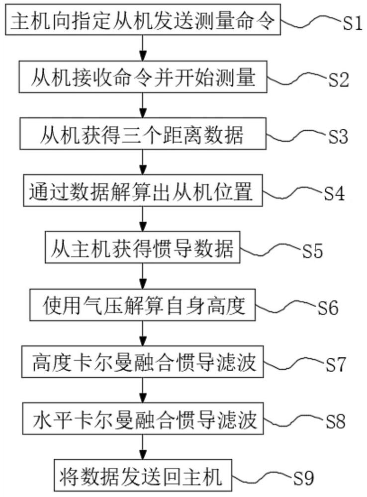
[0025] The following will clearly and completely describe the technical solutions in the embodiments of the present invention with reference to the accompanying drawings in the embodiments of the present invention. Obviously, the described embodiments are only some, not all, embodiments of the present invention. Based on the embodiments of the present invention, all other embodiments obtained by persons of ordinary skill in the art without making creative efforts belong to the protection scope of the present invention.

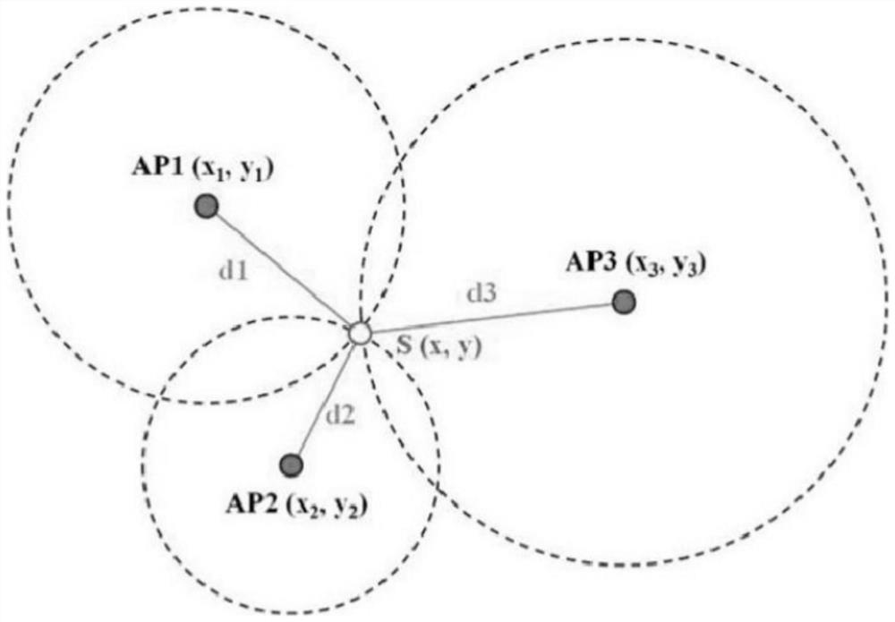
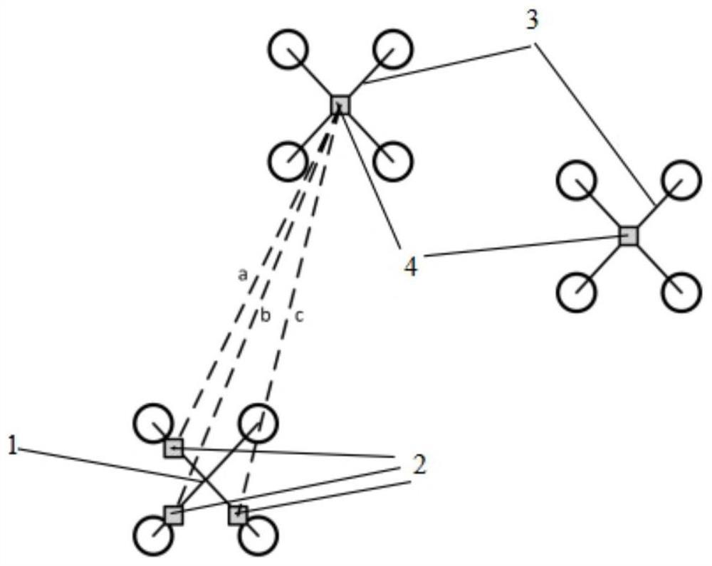
[0026] see Figure 1-3 , the present invention provides a technical solution: a UWB airborne UWB positioning method, including a cluster system and a positioning method, characterized in that: the cluster system includes a drone host 1, several drone slaves 3, a host Positioning module 2, slave positioning module 4, the master positioning module 2 is composed of three ranging modules, and its layout is an isosceles right triangle layout, the three modules are ...


PUM


Abstract

The invention discloses an airborne UWB positioning method for unmanned aerial vehicles. A cluster system and a positioning method are included. The method is characterized in that the cluster systemcomprises a host unmanned aerial vehicle, a plurality of slave unmanned aerial vehicles, a host positioning module and slave positioning modules; the host positioning module is composed of three distance measuring modules, the layout of the distance measuring modules is an isosceles right triangle, and the three distance measuring modules are located on the three vertexes of the triangle respectively; and each slave positioning module is composed of one distance measuring module and located in the geometric center of the corresponding unmanned aerial vehicle. According to the invention, the positioning of the relative positions between the host and the slaves is realized by adopting anchor points directly mounted on the host unmanned aerial vehicle and the labels on the slaves, the whole cluster takes the host as a reference, the position of the host determines the positions of the slaves under the condition that the formation is fixed, the accuracy of an operation result is ensured, anchor points do not need to be arranged in front of the cluster, mutual positioning between the host and slave unmanned aerial vehicles can be realized, the anchor point power supply problem is solved, and the positionable range can move along with movement of the host.

Description

technical field [0001] The invention relates to the field of electronics and information technology, in particular to an on-board UWB positioning method for an unmanned aerial vehicle. Background technique [0002] UWB is a carrier-free communication technology that uses nanosecond to microsecond non-sine wave narrow pulses to transmit data, and can also use it for point-to-point ranging. The principle is to measure the propagation time of radio waves in space to calculate Two-point distance, when applying one-to-multi-point ranging, can realize indoor and outdoor precise positioning by solving the corresponding relational formula. The existing technical solutions are attached figure 1 As shown, plane positioning generally uses three or more fixed anchor nodes AP1, AP2, and AP3, and the label node S measures the distance of the three anchor nodes respectively to obtain d1, d2, and d3. By using the triangle The centroid principle calculates the position of the label node S ...

Claims


Application Information

Patent Timeline
IPC IPC(8): G01S5/02G01S5/10
CPCG01S5/0257G01S5/0284G01S5/0294G01S5/10
Inventor 吴恩铭张靖宇莫浩杰马溢泽于宙陈济轩王启鑫李智恒唐莎潘一桐
Owner CIVIL AVIATION UNIV OF CHINA
Why Eureka
Try Eureka