A modeling elevation point screening method for road dem construction

A screening method and elevation point technology, applied in 3D modeling, structured data retrieval, instrumentation, etc., can solve problems such as interpolation effects, terrain expression distortion, and unevenness of the model surface, so as to avoid the retention and utilization of unreasonable points The effect of maximizing efficiency and simple process

Active Publication Date: 2022-05-06
CHUZHOU UNIV
View PDF5 Cites 0 Cited by
  • Summary
  • Abstract
  • Description
  • Claims
  • Application Information

AI Technical Summary

Problems solved by technology

However, this direct interpolation method also has some problems: First, when using elevation points and contour line data to construct a model, the shape of the model depends on the distribution of elevation points, and there is often a lack of corresponding edge elevation information at the road boundary , leading to the lack of elevation constraint information in the final form of road construction, which results in a large deviation from the actual road; second, in the construction process using traditional interpolation methods, there is mutual influence between elevation points, so on some special roads, such as elevated , tunnel entrance, etc., the elevation point on it will inevitably affect other elevation points when it is constructed, and the result of interpolation will form a slope in a local area, resulting in distortion of terrain expression; third, in real life, roads are not A single road is criss-crossed, and the intersection connects two roads, and its elevation information is also relatively complex, which will inevitably affect the interpolation, resulting in unevenness on the surface of the model, which deviates from the actual road
The key to this is to obtain reasonably distributed road modeling points. Too many points will easily cause local terrain oscillations during the interpolation process and destroy the morphological characteristics of the road DEM. Too few points will make it difficult to ensure the elevation accuracy of road DEM modeling.
In order to obtain a reasonable distribution and a suitable number of road modeling points, one way is to collect elevation points along the road with reference to the road elevation fluctuation characteristics, but this method will undoubtedly greatly increase the cost of modeling

Method used


Image

  • A modeling elevation point screening method for road dem construction
  • A modeling elevation point screening method for road dem construction
  • A modeling elevation point screening method for road dem construction

Examples


Embodiment 1

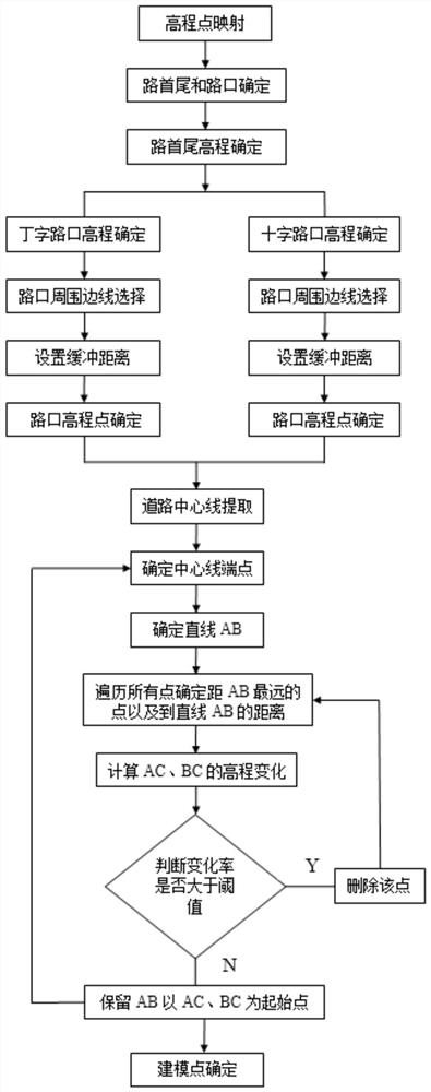
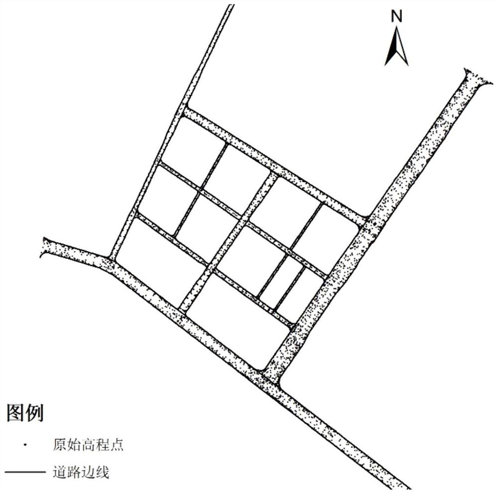
[0067] Although the existing road construction methods can better reflect the overall morphological characteristics of the road, for the intersection junctions of complex roads, the existing construction methods and application fidelity are poor, and the intersections cannot be smoothly transitioned. In addition, at the road boundary, due to the incomplete boundary elevation constraint information, the final shape of the road construction deviates greatly from the actual road. In order to verify the practicability of the method of the present invention for terrain fidelity simulations such as roads and intersections thereof, this example selects urban roads and surrounding elevation point data ( figure 2 ), the roads are staggered vertically and horizontally, in various shapes, and include different types of intersections described in the present invention, and the elevation point data are distributed among them. This example focuses on showing the overall elevation fluctuati...


PUM


Abstract

The invention discloses a method for screening elevation points oriented to road DEM construction. The method includes the following steps: S1, the elevation points are mapped to the road edge to form the initial road three-dimensional line; S2, for each road edge, the road head and the road end are determined according to the order of its storage nodes, and the intersection of the edge and other road edges is distinguished T-junction and intersection; S3, according to the principle of the shortest distance, determine the elevation information of the road head, road end and intersection; S4, according to the elevation information of the road head, road end and intersection determined in step S3, determine that the interior of the road needs to be preserved S5, interpolating internal elevation points to form elevation points with a specified step; S6, obtaining elevation points on the complete road edge to generate a three-dimensional road edge. The method of the invention includes two key technical links of road section division, endpoint elevation determination, and road internal elevation point selection, which can effectively ensure the morphological accuracy of subsequent road DEM modeling.

Description

technical field [0001] The invention belongs to the technical field of high-precision digital elevation model construction, and relates to a method for screening modeling elevation points in the process of constructing a road DEM to improve the elevation accuracy and shape accuracy of the construction road DEM. Background technique [0002] Digital Elevation Model (DEM for short) is the core content of national basic geographic data. At present, my country has initially completed the construction of 1:1 million, 1:250,000, 1:50,000 and 1:10,000 DEM data in some areas. These data play an indispensable and important role in the national economy, national defense construction and scientific research. Its application fields cover many fields such as surveying and mapping, transportation, military, water conservancy, agriculture, environment, resource management, planning and tourism. [0003] The existing classic DEM construction method can better reflect the natural undulation...

Claims


Application Information

Patent Timeline
Patent Type & Authority Patents(China)
IPC IPC(8): G06F16/29G06T17/05
CPCG06F16/29G06T17/05
Inventor 赵明伟张凯莉江岭杨灿灿王春徐燕
Owner CHUZHOU UNIV
Why Eureka
Try Eureka