Orchard local sparse mapping method and system based on binocular vision and RTK

A binocular vision, local sparse technology, applied in computer parts, character and pattern recognition, instruments, etc., can solve the problems of difficult operation technology, high labor cost, easy to be affected by light conditions, etc. Large, high labor cost effect

Pending Publication Date: 2020-11-17
GUANGDONG PROVINCE MODERN AGRI EQUIP RES INST +1
View PDF5 Cites 2 Cited by
  • Summary
  • Abstract
  • Description
  • Claims
  • Application Information

AI Technical Summary

Problems solved by technology

Due to the particularity of the orchard environment, currently commonly used mapping methods such as SLAM or UAV aerial photography cannot effectively solve the path planning problem of unmanned walking machines
For example, SLAM is mostly used indoors. In outdoor environments, visual SLAM is easily affected by light conditions. Laser SLAM is expensive, and single-line lidar cannot meet the needs at all.
Although UAV aerial photography can build a relatively high-precision top-view map, the labor cost is high, and professional personnel are required to take aerial photography and construct the map. If the environment changes, the map must be rebuilt. In addition, the coordinates of the map and the actual positioning are required. Matching, it is difficult for agricultural machinery operators or managers to operate technically

Method used


Image

  • Orchard local sparse mapping method and system based on binocular vision and RTK
  • Orchard local sparse mapping method and system based on binocular vision and RTK
  • Orchard local sparse mapping method and system based on binocular vision and RTK

Examples


specific Embodiment

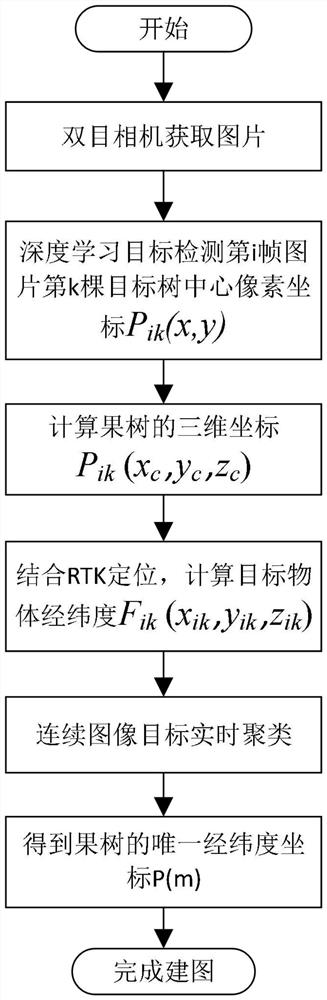
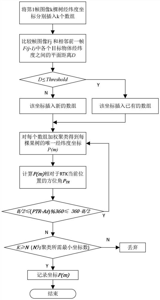
[0044] Such as Figure 1~4 As shown, it shows the specific implementation of the present invention, as shown in the figure, the specific embodiment of the system of the present invention is as follows:

[0045] A local sparse mapping system for orchards based on binocular vision and RTK, its implementation method includes:

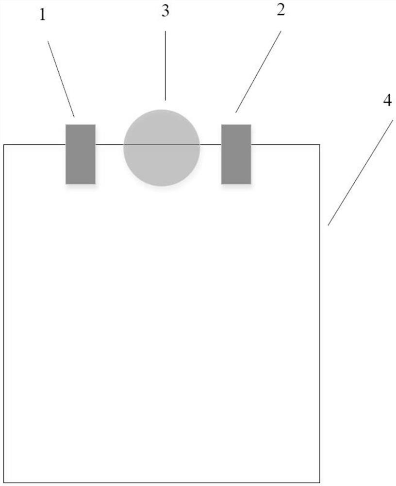
[0046] The system includes a binocular vision module and an RTK positioning module. The binocular vision module includes two left and right cameras, which are used to collect visual images of fruit trees in the orchard. The left and right visual images can be calculated to obtain the coordinates of the fruit trees; the RTK positioning module is used to obtain the latitude and longitude information of the location of the RTK module. The binocular vision module and RTK positioning module are installed on the work vehicle, and the left and right cameras of the binocular vision module are symmetrically installed on the left and right sides of the RTK antenna....


PUM


Abstract

The invention discloses an orchard local sparse mapping method and system based on binocular vision and RTK, and the method comprises the steps: recognizing a fruit tree based on a deep learning method through employing a high-precision positioning RTK and a binocular vision distance measurement module installed by an agricultural operation vehicle, obtaining the longitude and latitude coordinatesof each tree through binocular distance measurement in combination with the RTK, and obtaining local sparse mapping. The system disclosed by the invention comprises a binocular vision module and an RTK positioning module, the binocular vision module comprises a left camera and a right camera which are used for collecting orchard fruit tree vision images, and the left and right vision images are calculated to obtain fruit tree coordinates; the RTK positioning module acquires longitude and latitude information of the position where the RTK module is located; the binocular vision module and theRTK positioning module are installed on an operating vehicle, and a left camera and a right camera of the binocular vision module are symmetrically installed on the left side and the right side of anRTK antenna of the RTK positioning module.

Description

technical field [0001] The invention relates to an orchard mapping method and system, which finally realizes local sparse mapping of the orchard by acquiring the latitude and longitude coordinates of each fruit tree. Background technique [0002] Maps are the premise of path planning for unmanned agricultural machinery operations in the agricultural field. Especially, automatic navigation and driving in mountainous and hilly areas in my country are inseparable from maps of the operating environment. Due to the lack of operating environment maps, the current situation has been limited to a certain extent. The practical application and promotion of automatic driving operations of unmanned agricultural machinery in my country. At present, the method based on path planning, whether it is the traditional artificial potential field method, ant colony algorithm or A*, D* algorithm, or the popular SLAM (real-time positioning and mapping) or VSLAM (vision-based real-time positioning a...

Claims


Application Information

Patent Timeline
Patent Type & Authority Applications(China)
IPC IPC(8): G06K9/00G06K9/62G06N3/04
CPCG06V20/188G06V20/40G06N3/045G06F18/22G06F18/23G06F18/214
Inventor 刘海峰孟祥宝钟林忆潘明冯小川李腾宇刘朝阳卢嘉威黄家怿高翔
Owner GUANGDONG PROVINCE MODERN AGRI EQUIP RES INST
Why Eureka
Try Eureka