Method for enabling terrain to accurately fit strip-shaped model in real time in three-dimensional GIS

A technology of combining strips and terrain, applied in 3D modeling, image data processing, instruments, etc., can solve problems such as difficulty in generating smooth transitions, poor terrain effects, etc., and achieve good results.

Active Publication Date: 2020-12-01
北京国遥新天地信息技术股份有限公司
View PDF10 Cites 4 Cited by
  • Summary
  • Abstract
  • Description
  • Claims
  • Application Information

AI Technical Summary

Problems solved by technology

However, these two types of methods require manual preprocessing, and the effect of terrain modification is poor. It is difficult to generate a smooth transition effect between the corrected terrain and the original terrain next to the model.

Method used


Image

  • Method for enabling terrain to accurately fit strip-shaped model in real time in three-dimensional GIS
  • Method for enabling terrain to accurately fit strip-shaped model in real time in three-dimensional GIS
  • Method for enabling terrain to accurately fit strip-shaped model in real time in three-dimensional GIS

Examples


Embodiment Construction

[0023] The following will clearly and completely describe the technical solutions in the embodiments of the present invention with reference to the accompanying drawings in the embodiments of the present invention. Obviously, the described embodiments are only some, not all, embodiments of the present invention.

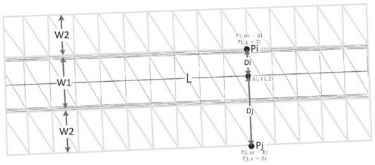
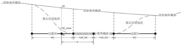
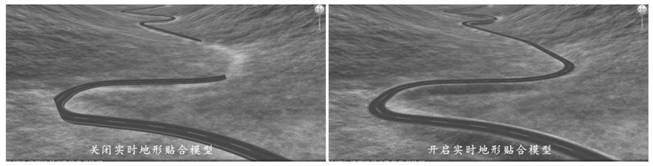
[0024] refer to Figure 1-5 A method for accurately fitting terrain to a strip model in real time in a three-dimensional digital earth, comprising the following steps: 1) scheduling quadtree-structured terrain tiles according to different heights of cameras or viewing angles, and loading DEM data to generate heightmap textures; 2) Construct the centerline buffer triangular grid according to the centerline of the strip model, the width of the model section, and the width of the transition zone; 3) For the terrain tile intersecting with the route buffer model, the centerline buffer triangular The block height map texture is transmitted to the GPU together, and a new he...


PUM


Abstract

The invention discloses a method for enabling terrain to accurately fit a strip-shaped model in real time in a three-dimensional GIS (Geographic Information System), which comprises the following steps of scheduling terrain tiles of a quadtree structure according to different heights of a camera or a visual angle, and loading DEM (Digital Elevation Model) data to generate height map textures; constructing a center line buffer area triangular mesh according to the center line of the strip-shaped model, the section width of the model and the width of the transition area; for a terrain tile intersected with the triangular mesh of the center line buffer area, transmitting the triangular mesh of the center line buffer area and the terrain tile height map texture into a GPU (Graphics ProcessingUnit) together, and performing parallel correction calculation on each pixel of the height map texture once by rendering to a texture technology to obtain a new height map texture; and constructing aterrain tile triangular mesh by using the new height map texture, rendering the terrain tile, generating a topographic image accurately fitting the strip model, and outputting the topographic image todisplay equipment.

Description

technical field [0001] The invention relates to the technical field of digital earth geographic data simulation in a three-dimensional GIS geographic information system, in particular to a method for accurately fitting terrain to a strip model in real time in a three-dimensional digital earth. Background technique [0002] 3D geographic information system digital earth simulation technology combines computer technology, graphic image technology, control technology and other disciplines to carry out 3D modeling of the real world and drive and display it in real time in 3D scenes, thereby extending human sensory organs. Using elevation data, satellite images, models, etc. to construct 3D simulation scenes on the digital earth, it can intuitively display geographical information such as geographical location, topography, soil hydrology, vegetation and buildings, and users can freely manipulate and roam in the 3D scene. In some 3D geographic information simulation fields, some l...

Claims


Application Information

Patent Timeline
Patent Type & Authority Applications(China)
IPC IPC(8): G06T17/05
CPCG06T17/05G06T2210/04
Inventor 肖剑陈超牛玉刚梁长青
Owner 北京国遥新天地信息技术股份有限公司
Why Eureka
Try Eureka