Map model based on automatic driving application scene and application method thereof

A technology for automatic driving and application scenarios, applied in character and pattern recognition, measuring devices, instruments, etc., can solve the problem of not realizing deep data fusion, and achieve the effect of flexible calling and planning, saving time and cost, and reducing energy consumption.

Pending Publication Date: 2020-12-18
沃行科技(南京)有限公司
View PDF0 Cites 5 Cited by
  • Summary
  • Abstract
  • Description
  • Claims
  • Application Information

AI Technical Summary

Problems solved by technology

These methods that rely too much on the vehicle or perception system map have not achieved true deep data fusion, and cannot meet people's requirements from the perspective of safety and production efficiency.

Method used


Image

  • Map model based on automatic driving application scene and application method thereof

Examples


Embodiment Construction

[0028] The present invention will be further described below in conjunction with the accompanying drawings.

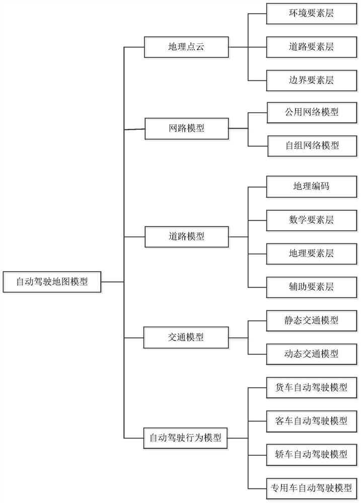
[0029] The map model based on the automatic driving application scene of the present invention includes geographical point cloud, network model, road model, traffic model and automatic driving behavior model.

[0030] Geographic point cloud includes environment element layer, road element layer and boundary element layer, environment element layer includes environment type and layer optimization, used for feature point extraction and eliminating coordinate errors, environment type is classified according to point cloud feature points, layer optimization Optimization method with SLAM. The road element layer includes road segmentation and road identification. Segmentation and extraction boundaries are used to limit the behavior of autonomous vehicles. Road segmentation uses RANSAC line-surface extraction to extract road areas and road surfaces. Road identification uses H...


PUM


Abstract

The invention discloses a map model based on an automatic driving application scene and an application method thereof. The model comprises a geographic point cloud, a network model, a road model, a traffic model and an automatic driving behavior model. The geographic point cloud comprises an environmental element layer, a road element layer and a boundary element layer, wherein the network model comprises a public network model and an ad hoc network model, the road model comprises a mathematical element layer, a geographic element layer, an auxiliary element layer and a geographic code, and the traffic model comprises a dynamic traffic model and a static traffic model; the automatic driving behavior model comprises a truck automatic driving behavior model, a passenger car automatic drivingbehavior model, a car automatic driving behavior model and a special car automatic driving behavior model. According to the map model disclosed in the invention, traffic rules are embedded into intelligent driving, so that the map model is fused with the driving depth of the automatic driving vehicle, and the map model controls the automatic driving vehicle.

Description

Technical field: [0001] The present invention relates to an automatic driving map model and an application method thereof, in particular to a map model based on an automatic driving application scene and an application method thereof. Background technique: [0002] With the advent of the era of big data, people's production and life have higher and higher requirements for the operational efficiency and basic functions of transportation. attention. However, most of the current mainstream technical means are attached to the perception functions of the vehicle devices such as sensors, radars, and cameras. For example, self-driving parking, self-driving on specific roads and other single-vehicle smart technologies; or focusing on creating maps with higher precision and better rendering effects, such as layer production, scene map rendering, etc. These methods that rely too much on the vehicle or perception system map have not achieved true deep data fusion, and cannot meet peo...

Claims


Application Information

Patent Timeline
Patent Type & Authority Applications(China)
IPC IPC(8): G06K9/00G01C21/00G01C21/36
CPCG01C21/005G01C21/3667G06V20/588
Inventor 刘树全董钊志张婉蒙陈艳楠岳呈祥
Owner 沃行科技(南京)有限公司
Why Eureka
Try Eureka