A UAV dynamic geo-fence planning method based on airspace grid

A geo-fence and UAV technology, applied in flight plan management, aircraft traffic control, computer components, etc., can solve problems such as low utilization rate and shortage of low-altitude airspace resources, and achieve accurate and efficient utilization

Active Publication Date: 2021-09-24
NANJING UNIV OF AERONAUTICS & ASTRONAUTICS
View PDF10 Cites 0 Cited by
  • Summary
  • Abstract
  • Description
  • Claims
  • Application Information

AI Technical Summary

Problems solved by technology

[0003] Purpose of the invention: The purpose of the present invention is to provide a dynamic geo-fence planning method for unmanned aerial vehicles based on airspace gridding, to solve the problem of low-altitude air traffic management caused by existing low-altitude air traffic management methods such as setting up isolated airspace or static geo-fence planning. Practical issues such as tight airspace resources and low utilization

Method used


Image

  • A UAV dynamic geo-fence planning method based on airspace grid
  • A UAV dynamic geo-fence planning method based on airspace grid
  • A UAV dynamic geo-fence planning method based on airspace grid

Examples


Embodiment Construction

[0074] The present invention will be further described below in conjunction with the accompanying drawings.

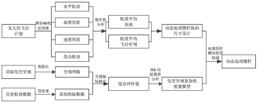
[0075] figure 1 It is a flowchart of the present invention, which may specifically include the following steps:

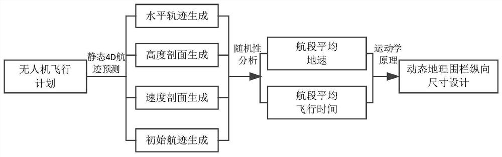
[0076] S1. Considering the randomness of the actual trajectory of the UAV, and predicting the flexible trajectory of the UAV flight plan;

[0077] For the target flight plan, firstly, the initial static 4D trajectory model of the UAV is established in combination with the performance parameters of the UAV, and then the trajectory randomness characteristics of the UAV in actual flight are analyzed, and the UAV is analyzed according to the trajectory randomness characteristics. The initial 4D track model is improved, and finally a flexible 4D track prediction model is generated.

[0078] The initial static 4D track prediction model of the UAV is specifically: 4D track refers to the accurate description of the aircraft flight track based on the four-dimensio...


PUM


Abstract

The invention discloses a UAV dynamic geographic fence planning method based on low-altitude airspace gridding, which includes considering the randomness characteristics of the UAV's actual track, and performing flexible track prediction on the UAV flight plan; combined with the UAV Based on the prediction results of the flexible track, the longitudinal length dimension design of the dynamic geo-fence is carried out; the historical track data within the target airspace is preprocessed, and the airspace is uniformly gridded and numbered; the key indicators affecting the complexity of the low-altitude airspace are defined , the kernel K-means clustering method is used to cluster the airspace grid to realize the hierarchical measurement results of the complexity of the low-altitude airspace; combined with the complexity of the low-altitude airspace grid, the horizontal range planning of the dynamic geo-fence dynamic geo-fence is carried out. For the first time, this method proposes a complete UAV dynamic geo-fence planning method and applies it to low-altitude airspace air traffic management, which can effectively improve the utilization rate of low-altitude airspace and help alleviate the problem of resource shortage in low-altitude airspace.

Description

technical field [0001] The invention relates to air traffic planning and management technology, in particular to a method for planning a dynamic geographic fence of an unmanned aerial vehicle based on airspace gridding. Background technique [0002] With the continuous deepening of civilian UAV applications and the rapid expansion of the UAV market, the operation and management of low-altitude airspace in the future will face huge challenges. The shortage and improper allocation of low-altitude airspace resources will bring many problems. On the one hand, regarding the air traffic management methods of low-altitude airspace, the traditional management mode of dividing isolated airspace or planning static geo-fences is a relatively extensive management mode. Some of the busier airspace resources caused by economic or geographical factors will not be able to meet the demand. On the other hand, due to the variety of aircraft types, aircraft sizes and flight modes in the low-al...

Claims


Application Information

Patent Timeline
Patent Type & Authority Patents(China)
IPC IPC(8): G08G5/00G06K9/62G06F17/18
CPCG08G5/003G06F17/18G06F18/23213
Inventor 汤新民顾俊伟郑鹏程李腾
Owner NANJING UNIV OF AERONAUTICS & ASTRONAUTICS
Why Eureka
Try Eureka