Remote sensing data and social survey combined regional economic development estimation method and system

A technology for remote sensing data and areas, applied in data processing applications, market data collection, computing, etc., can solve the problems of low spatial resolution of remote sensing night light data, easy to be affected by human subjective factors, lack of statistical data, etc., to achieve coverage Wide range, low cost and highly automated effects

A technology for remote sensing data and areas, applied in data processing applications, market data collection, computing, etc., can solve the problems of low spatial resolution of remote sensing night light data, easy to be affected by human subjective factors, lack of statistical data, etc., to achieve coverage Wide range, low cost and highly automated effects

CN112200619APending Publication Date: 2021-01-08ZHEJIANG OCEAN UNIV

Image

  • Remote sensing data and social survey combined regional economic development estimation method and system
  • Remote sensing data and social survey combined regional economic development estimation method and system
  • Remote sensing data and social survey combined regional economic development estimation method and system

Examples


Embodiment Construction

[0043] The following will clearly and completely describe the technical solutions in the embodiments of the present invention with reference to the accompanying drawings in the embodiments of the present invention. Obviously, the described embodiments are only some, not all, embodiments of the present invention. Based on the embodiments of the present invention, all other embodiments obtained by persons of ordinary skill in the art without making creative efforts belong to the protection scope of the present invention.

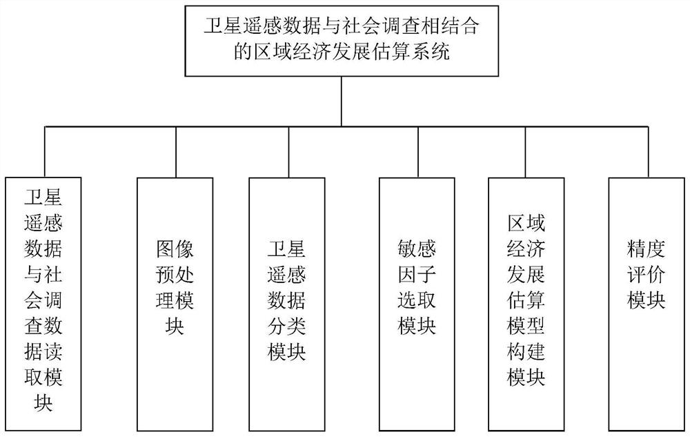
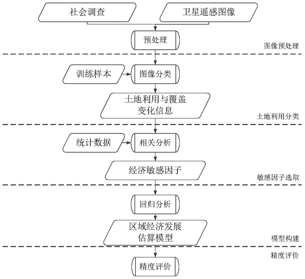
[0044]Such as figure 1 As shown, the satellite remote sensing data and social survey data reading module of the present invention input the satellite remote sensing data in image format and the social survey data in text format; the image preprocessing module carries out radiometric calibration, atmospheric correction, image Operations such as splicing and cropping; the satellite remote sensing data classification module selects training samples according to t...


PUM


Abstract

The invention discloses a remote sensing data and social survey combined regional economic development estimation method and system. The system comprises a data reading module, an image preprocessingmodule, a classification module, a sensitive factor selection module, a model construction module and a precision evaluation module. The method comprises the following steps: S1, selecting a researcharea, and obtaining a satellite remote sensing image and social survey data of a corresponding year; s2, operating the obtained satellite remote sensing image to obtain a satellite remote sensing image covering the whole research area; s3, classifying the land utilization types of the research area; s4, selecting a sensitive factor; s5, constructing a regional economic development estimation model; and S6, carrying out precision evaluation on the regional economic development estimation model. The method and system provide a new idea for regional economic development prediction and economic data correction, provide a new approach for observing economic activities and influences thereof for human beings, and have the advantages of simple process, easy operation, strong objectivity and the like.

Description

technical field [0001] The invention relates to the field of combining remote sensing data and social survey, in particular to a regional economic development estimation method and system combining satellite remote sensing data and social survey. Background technique [0002] Regional economic development refers to economic activities such as economic growth, population growth, industrial organization and structural upgrading within a certain time and space. With the acceleration of social development, problems such as unbalanced regional economic development, widening gap between urban and rural areas, and saturation of urban resource carrying capacity have become increasingly prominent, which has attracted more and more attention and thinking from scientists and sociologists. Evaluating regional economic development is conducive to objectively understanding social issues such as resource consumption, environmental pollution, and population expansion, and is of great signif...

Claims


Application Information

Patent Timeline
08 Jan 2021
Publication
CN112200619A
IPC
G06Q30/02; G06Q50/26
CPC
G06Q30/0202; G06Q30/0201; G06Q50/26
Inventors
陈超; 汪李彦