Satellite navigation monitoring system and monitoring method

A monitoring system and satellite navigation technology, which is applied in the field of satellite navigation, can solve the problems of easy error in monitoring data, inconvenient satellite monitoring and calibration, easy loss of monitoring data, etc., and achieve the effects of improving receiving performance, ensuring accuracy, and reducing work pressure

Inactive Publication Date: 2021-01-12
广州郝舜科技有限公司
View PDF0 Cites 1 Cited by
  • Summary
  • Abstract
  • Description
  • Claims
  • Application Information

AI Technical Summary

Problems solved by technology

[0004] Aiming at the deficiencies of the prior art, the present invention provides a satellite navigation monitoring system and a monitoring method, which have the advantages of strong satellite signal receiving ability, easy data analysis, difficult loss of monitoring data, small information processing error and easy staff analysis, etc. , to solve the problem that the existing satellite navigation monitoring system is difficult to receive satellite signals more accurately, the integrated data information is relatively messy, the monitoring data is prone to errors, and the monitoring data is easy to be lost, which is not convenient for the staff to accurately monitor the satellites Monitor Calibration Issues

Method used


Image

  • Satellite navigation monitoring system and monitoring method
  • Satellite navigation monitoring system and monitoring method
  • Satellite navigation monitoring system and monitoring method

Examples


Embodiment Construction

[0038] The following will clearly and completely describe the technical solutions in the embodiments of the present invention with reference to the accompanying drawings in the embodiments of the present invention. Obviously, the described embodiments are only some, not all, embodiments of the present invention. Based on the embodiments of the present invention, all other embodiments obtained by persons of ordinary skill in the art without making creative efforts belong to the protection scope of the present invention.

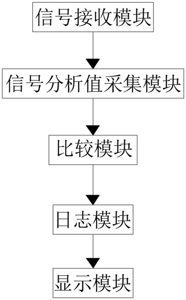
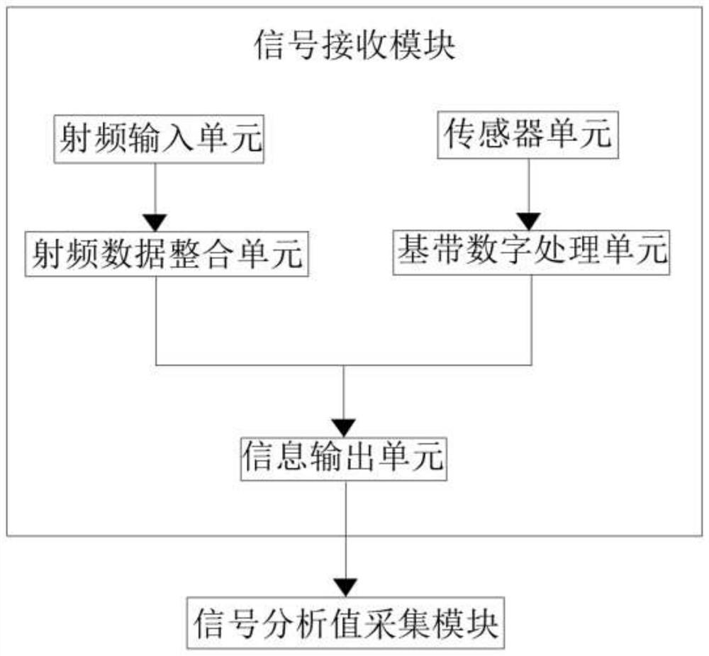
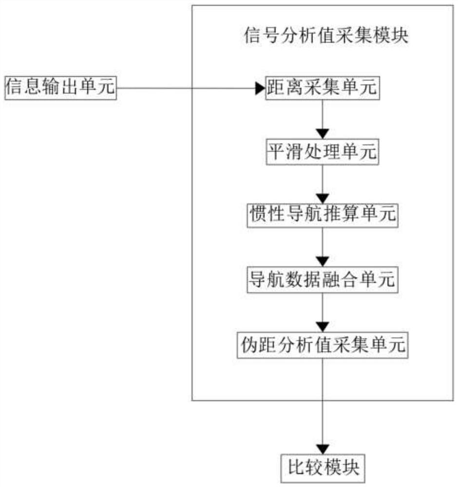
[0039] see Figure 1-4 , the present invention provides a technical solution: a satellite navigation monitoring system, including a signal receiving module, the output end of the signal receiving module is electrically connected to the input end of the signal analysis value acquisition module, and the output end of the signal analysis value acquisition module is connected to the data comparison module The input end of the data comparison module is electrically...


PUM


Abstract

The invention relates to the technical field of satellite navigation, and discloses a satellite navigation monitoring system and monitoring method. The satellite navigation monitoring system comprisesa signal receiving module, wherein the output end of the signal receiving module is electrically connected with the input end of a signal analysis value acquisition module, and the output end of thesignal analysis value acquisition module is electrically connected with the input end of a data comparison module; and the output end of the data comparison module is electrically connected with the input end of a log module. According to the satellite navigation monitoring system and the satellite navigation monitoring method, the radio frequency input unit, the radio frequency data integration unit, the sensor unit and the baseband digital processing unit are matched for use, so the radio frequency input unit and the radio frequency data integration unit receive satellite signals; the sensorunit and the baseband digital processing unit receive the position signal of the signal receiving module, so the receiving performance of the system for the satellite signal is further improved, andthe accuracy of the position information of the signal receiving module is ensured.

Description

technical field [0001] The invention relates to the technical field of satellite navigation, in particular to a satellite navigation monitoring system and a monitoring method. Background technique [0002] Satellite navigation system is a technology that uses navigation satellites to navigate and locate users on the ground, ocean, air and space. It has been thousands of years to use the sun, moon and other natural celestial bodies for navigation. It was proposed, but it was not realized until the 1960s. In 1964, the United States built the "Meridian" satellite navigation system and delivered it to the Navy. It began to be used by civilians in 1967. In 1973, it began to develop the "Navigation Star" global positioning system. Similar satellite navigation systems have been established, and France, Japan, and China have also carried out satellite navigation research and test work. Satellite navigation combines the advantages of traditional navigation systems, and truly realizes...

Claims


Application Information

Patent Timeline
Patent Type & Authority Applications(China)
IPC IPC(8): G01S19/23
CPCG01S19/23
Inventor 杨先文
Owner 广州郝舜科技有限公司
Why Eureka
Try Eureka