GIS-based rural land value grading method and GIS-based rural land value grading system

A land and rural technology, applied in the field of GIS-based rural land value grading method and its system, can solve problems such as unclear responsibilities, lack of evaluation platforms and mechanisms, and poor land circulation

Pending Publication Date: 2021-02-02
土流集团有限公司
View PDF0 Cites 0 Cited by
  • Summary
  • Abstract
  • Description
  • Claims
  • Application Information

AI Technical Summary

Problems solved by technology

The three rights belong to different power subjects, and the responsibilities of the relevant management departments are not clear, resulting in many land transactions, high costs, difficulties in confirming rights, and poor land circulation.
This also makes the evaluation of "rural land value" difficult. There are few cases of open market transactions, and there is a lack of a good evaluation platform and mechanism.

Method used


Image

  • GIS-based rural land value grading method and GIS-based rural land value grading system
  • GIS-based rural land value grading method and GIS-based rural land value grading system
  • GIS-based rural land value grading method and GIS-based rural land value grading system

Examples


Embodiment Construction

[0029] The following will clearly and completely describe the technical solutions in the embodiments of the present invention with reference to the accompanying drawings in the embodiments of the present invention. Obviously, the described embodiments are only some, not all, embodiments of the present invention. Based on the embodiments of the present invention, all other embodiments obtained by persons of ordinary skill in the art without making creative efforts belong to the protection scope of the present invention.

[0030] Include the following steps:

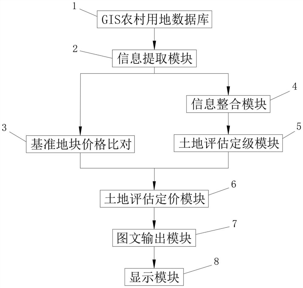
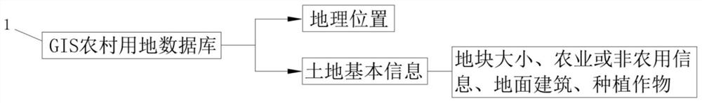
[0031] S1: Connect the rural land value system with the GIS rural land database 1, and import the geographic location and basic land information of the land to be rated and evaluated from the GIS rural land database 1, and extract and export it through the information extraction module 2 To facilitate later use, the information extraction module 2 then derives some benchmark plots that have been graded and priced and the b...


PUM


Abstract

The invention discloses a GIS-based rural land value grading method and system, and the method comprises the steps: carrying out the networking connection of a rural land value system and a GIS ruralland database, and importing the geographic position and land basic information of a to-be-graded land parcel from the interior of the GIS rural land database; employing the information extraction module for extracting and exporting to facilitate later use, and then employing the information extraction module for exporting a plurality of graded and priced reference land parcels and basic information and price information of the plurality of reference land parcels from the interior of the GIS rural land database according to the land basic information. According to the GIS rural land database,the information of the GIS map database is extracted and output, the advanced GIS calculation and system integration thought is applied, the to-be-graded priced land parcel and the similar reference land parcel matched with the to-be-graded priced land parcel are extracted in a big data mode, and by referring to the grading and pricing mode of the reference land parcel, the grading and pricing method is more objective, and the value determination is more accurate.

Description

technical field [0001] The present invention relates to the technical field of land value grading, more specifically, the present invention is a GIS-based rural land value grading method and system thereof. Background technique [0002] For a long time, the ownership of rural land in my country belongs to the collective, the right to contract land belongs to farmers, and the right to manage contracted land mainly belongs to farmers in villages or villager groups, while the management departments of township governments are responsible for rural land transfer and other matters. The three rights belong to different power subjects, and the responsibilities of the relevant management departments are unclear, resulting in many land transactions, high costs, difficulties in confirming rights, and poor land circulation. This has also caused the key to the difficulty of evaluating "rural land value", as there are few cases of open market transactions and a lack of a good evaluation ...

Claims


Application Information

Patent Timeline
Patent Type & Authority Applications(China)
IPC IPC(8): G06Q30/02G06Q50/26G06F16/29
CPCG06Q30/0206G06Q30/0278G06Q50/26G06F16/29
Inventor 伍勇
Owner 土流集团有限公司
Why Eureka
Try Eureka