Supercharge Your Innovation With Domain-Expert AI Agents!

Multilevel altitude maps

A height map and height value technology, applied in the field of height map and its creation, can solve the problems of unavailability and unacceptable horizontal positioning accuracy, and achieve the effect of improving height estimation

Pending Publication Date: 2021-03-16
HERE GLOBAL BV
View PDF6 Cites 2 Cited by
  • Summary
  • Abstract
  • Description
  • Claims
  • Application Information

AI Technical Summary

Problems solved by technology

[0009] First, while GNSS-based height estimates work relatively well outdoors under good signal conditions, estimates are generally not available indoors, and when they are indoors they have an accuracy of about 50 meters, which is good for indoor floor levels Unacceptable in terms of positioning accuracy
[0010] Second, while it is possible to estimate heights based on height maps, this is only valid in height-specific locations (i.e., locations where there is only one ground height and no multi-level structure)

Method used


Image

  • Multilevel altitude maps
  • Multilevel altitude maps
  • Multilevel altitude maps

Examples


Embodiment Construction

[0096] The following description is intended to deepen the understanding of the present invention, and should be understood as supplementing and read together with the description provided in the above summary of the present specification.

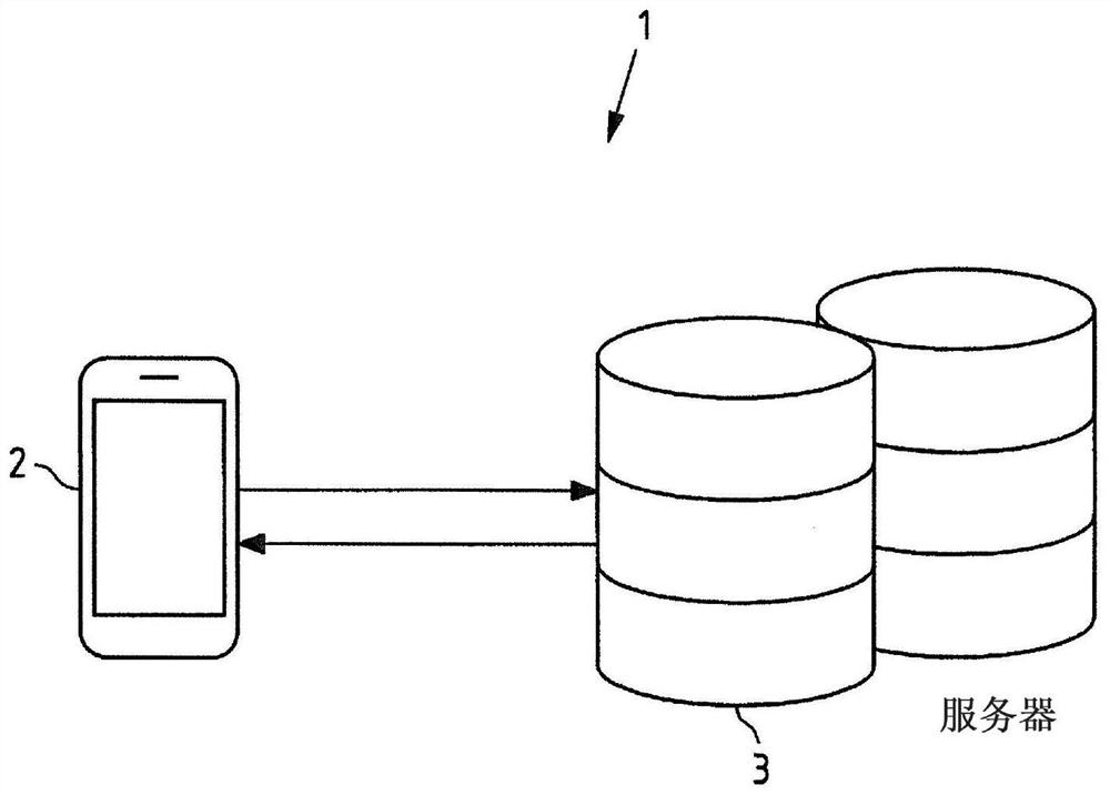
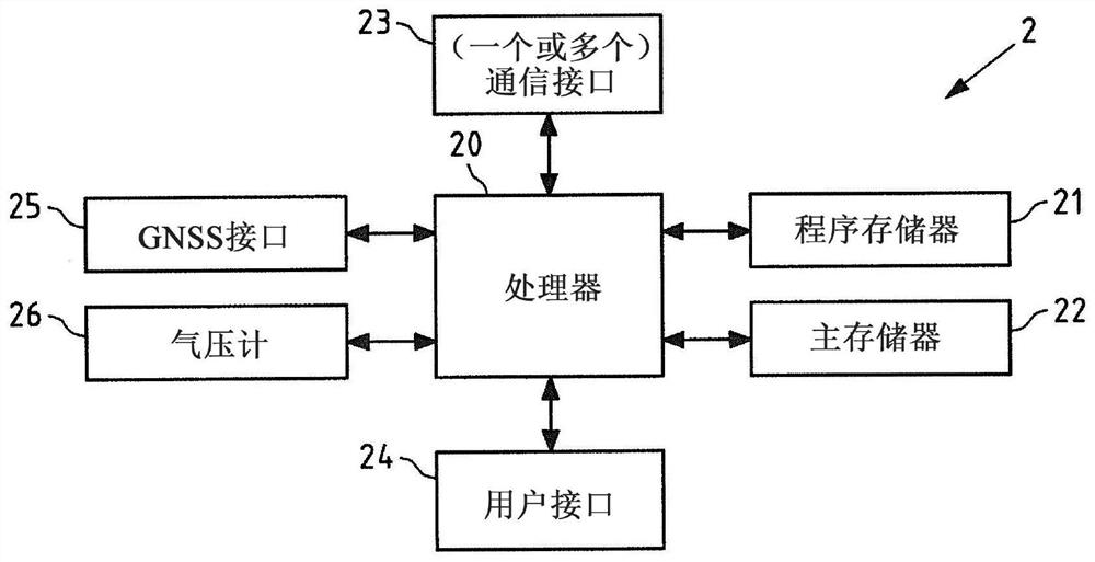
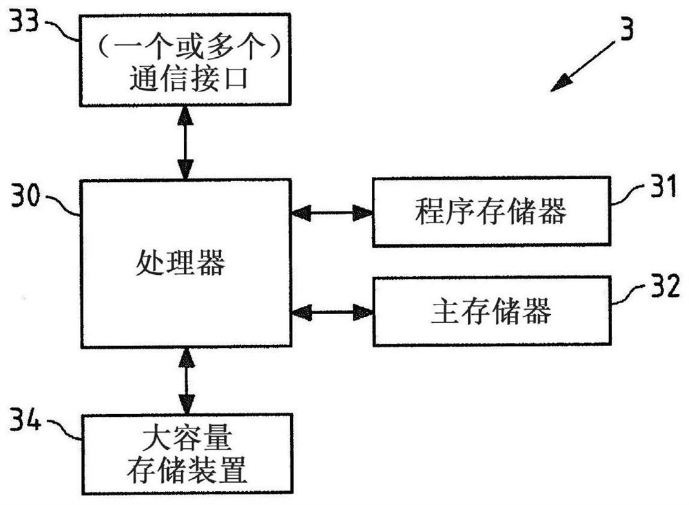
[0097] figure 1 is a block diagram of the system 1 of a mobile device 2 and a server 3, which may both be exemplary embodiments of an apparatus according to the invention and which may individually or together perform an exemplary embodiment of a method according to the invention. For details of mobile device 2 and server 3 refer to figure 2 with image 3 to describe, among them, figure 2 yes figure 1 An exemplary block diagram of a mobile device 1, image 3 yes figure 1 Exemplary block diagram of server 3.

[0098] For example, mobile device 2 may be part of, or may be, a cellular phone, personal digital assistant, laptop, tablet, or wearable device. The server 3 may be, for example, a server located remotely from the mobile devi...


PUM


Abstract

The invention relates to a method, performed by at least one apparatus. The method comprises obtaining sample measurements at least in part comprising altitude information and observed in an area at least in part represented by an altitude map, the altitude map comprising sub-sections representing respective sub-areas of the area; The method further comprises determining altitude estimates from the altitude information. The method further comprises updating one or more altitude estimate distributions associated with respective sub-sections of the altitude map based on the determined altitude estimates. The method further comprises determining, for one or more sub- sections of the altitude map, whether a respective sub-section of the altitude map represents a single level sub-area or multilevel sub-area, based on respective altitude estimate distributions associated with respective sub-sections of the altitude map.

Description

technical field [0001] The invention relates to the field of height maps and their creation, which can be used in particular for positioning purposes, and in particular for indoor positioning. Background technique [0002] Indoor positioning requires novel systems and solutions specially developed and deployed for this purpose. Traditional positioning technologies used primarily outdoors, ie, satellite and cellular positioning technologies, cannot deliver indoors the performance required for a seamless and equivalent navigation experience in both environments. It is difficult to achieve the required positioning accuracy (2m (meters) to 3m), coverage (~100%) and floor detection at a satisfactory level of performance using systems and signals that are not pre-designed and specified for indoor use. Satellite based radio navigation signals do not penetrate walls and roofs at all for adequate signal reception, and cellular signals have too narrow a bandwidth to allow for accurat...

Claims


Application Information

Patent Timeline
Patent Type & Authority Applications(China)
IPC IPC(8): G01C5/06G01C21/00G01C21/20G01C21/32
CPCG01C5/06G01C21/005G01C21/206G01C21/3844G01C21/3878G01C21/383
Inventor 劳里·阿尔内·约翰内斯·维罗拉帕维尔·伊万诺夫亨利·亚科·尤利乌斯·努尔米宁
Owner HERE GLOBAL BV
Features
  • R&D
  • Intellectual Property
  • Life Sciences
  • Materials
  • Tech Scout
  • Unparalleled Data Quality
  • Higher Quality Content
  • 60% Fewer Hallucinations
Learn More