DEM super-resolution method based on convolutional neural network

A convolutional neural network and super-resolution technology, applied in the field of terrain mapping, can solve the problems of similarity-dependent determination and small adaptability, and achieve the effects of high accuracy, improved accuracy and improved robustness

Inactive Publication Date: 2017-04-26
HUAZHONG UNIV OF SCI & TECH
View PDF3 Cites 20 Cited by
  • Summary
  • Abstract
  • Description
  • Claims
  • Application Information

AI Technical Summary

Problems solved by technology

This method improves the accuracy of high-resolution DEM data to a certain extent, but the disadvantage is

Method used


Image

  • DEM super-resolution method based on convolutional neural network
  • DEM super-resolution method based on convolutional neural network
  • DEM super-resolution method based on convolutional neural network

Examples


Embodiment 1

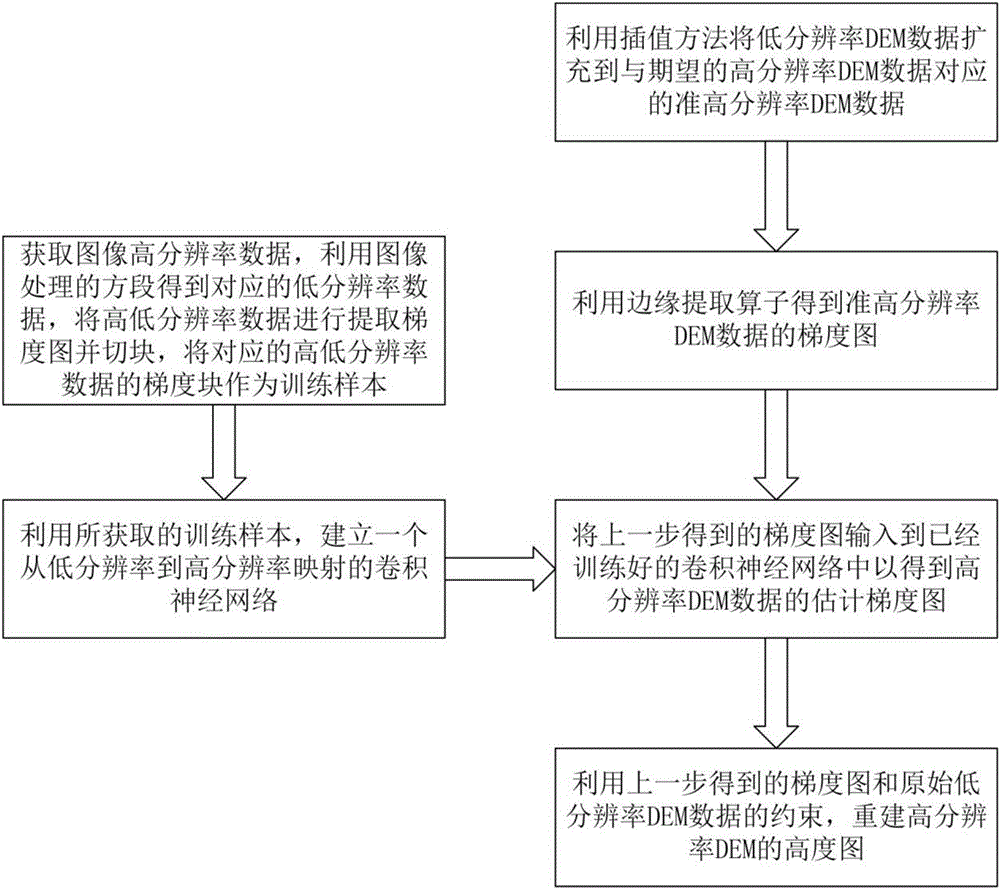
[0065] This embodiment 1 includes the following steps:

[0066] (1) Use the bicubic interpolation method to expand the low-resolution DEM data by s times to obtain the quasi-high-resolution DEM data of the same scale as the expected high-resolution DEM data.

[0067] (2) Use Sobel operator to extract edge maps in X and Y directions of quasi-high resolution DEM data.

[0068] (3) Input the gradient map into the super-resolution convolutional neural network trained on the high- and low-resolution image data to obtain the estimated gradient map of the high-resolution DEM data;

[0069] Wherein, the super-resolution convolutional neural network trained on the high and low resolution image data is obtained according to the following steps:

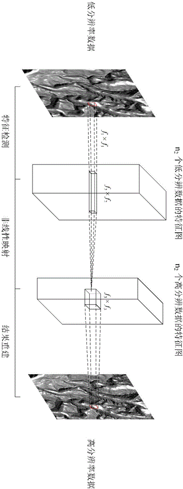
[0070] (3-1) Acquire a large amount of image high-resolution data, perform double-triple down-sampling and then double-triple up-sampling on all images in the image database to obtain the corresponding low-resolution image data, and use the high- and low...


PUM


Abstract

The invention discloses a DEM super-resolution method based on a convolutional neural network. The method includes following steps: (1) obtaining a super-resolution convolutional neural network through training according to low-resolution image data and high-resolution image data corresponding to each other in advance; (2) extending to-be-processed low-resolution DEM data by employing an interpolation method, and obtaining quasi-high-resolution DEM data having the same scale with expected high-resolution DEM data; (3) obtaining a gradient map of the quasi-high-resolution DEM data by employing en edge extraction operator; (4) inputting the gradient map to the super-resolution convolutional neural network, and obtaining an estimation gradient map of the high-resolution DEM data; and (5) reconstructing a height map of the high-resolution DEM based on constraint of the estimation gradient map and the to-be-processed low-resolution DEM data. According to the super-resolution method, the robustness is high, and the precision of the reconstruction result is high.

Description

Technical field [0001] The invention belongs to the technical field of terrain surveying and mapping, and more specifically, relates to a DEM super-resolution method based on a convolutional neural network. Background technique [0002] Digital Elevation Model (DEM) is a branch of digital terrain model. It is a digital model that expresses ground elevation in the form of a set of ordered numerical arrays. It has a wide range of application requirements in economic and national defense construction. For example, in trajectory planning, people hope to use more accurate terrain data to achieve the best planning results. Therefore, people’s pursuit of high-precision terrain models is an eternal theme. . In order to obtain a high-precision terrain model, two methods are usually used. One method usually uses higher-precision measurement equipment such as high-resolution remote sensing images and intensive measurement to achieve the purpose of improving accuracy. This method has a hi...

Claims


Application Information

Patent Timeline
IPC IPC(8): G06T5/00
CPCG06T5/003G06T2207/20081G06T2207/20084
Inventor 侯文广徐泽楷陈子轩卢晓东易玮玮
Owner HUAZHONG UNIV OF SCI & TECH
Why Eureka
Try Eureka