Method and device for unmanned vehicle detection of side rockfall

A technology for unmanned vehicles and falling rocks, which is applied to devices using optical methods, measuring devices, and optical devices, etc. It can solve the problems of being affected by terrain, large manpower investment, and low degree of automation, and achieves a high degree of intelligence. The effect of high safety and high accuracy

Active Publication Date: 2022-03-04
SHANGHAI BOONRAY INTELLIGENT TECH CO LTD
View PDF7 Cites 0 Cited by
  • Summary
  • Abstract
  • Description
  • Claims
  • Application Information

AI Technical Summary

Problems solved by technology

Although these methods have played a positive role in the early warning of landslides, they have some disadvantages, such as being affected by the terrain, not being able to observe continuously, the degree of automation is not high, the human input is too large, and the data cannot be processed in real time.

Method used


Image

  • Method and device for unmanned vehicle detection of side rockfall
  • Method and device for unmanned vehicle detection of side rockfall
  • Method and device for unmanned vehicle detection of side rockfall

Examples


Embodiment 1

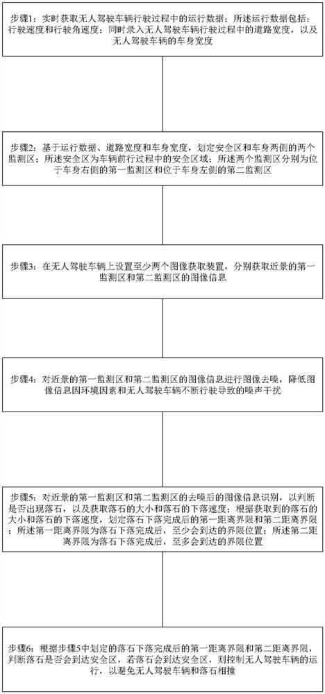
[0031] Such as figure 1 Shown, unmanned vehicle detects the method that side rockfall occurs, it is characterized in that, described method carries out the following steps:

[0032] Step 1: Obtain real-time operating data during the driving process of the unmanned vehicle; the operating data includes: driving speed and driving angular velocity; at the same time, enter the road width during the driving process of the unmanned vehicle and the body width of the unmanned vehicle;

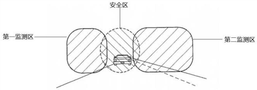
[0033] Step 2: Based on the operating data, road width and vehicle body width, delineate the safety zone and two monitoring areas on both sides of the vehicle body; the safety zone is the safety zone during the vehicle’s forward movement; The first monitoring area on the right side of the vehicle body and the second monitoring area on the left side of the vehicle body;

[0034] Step 3: Install at least two image acquisition devices on the unmanned vehicle to acquire the image information of the first m...

Embodiment 2

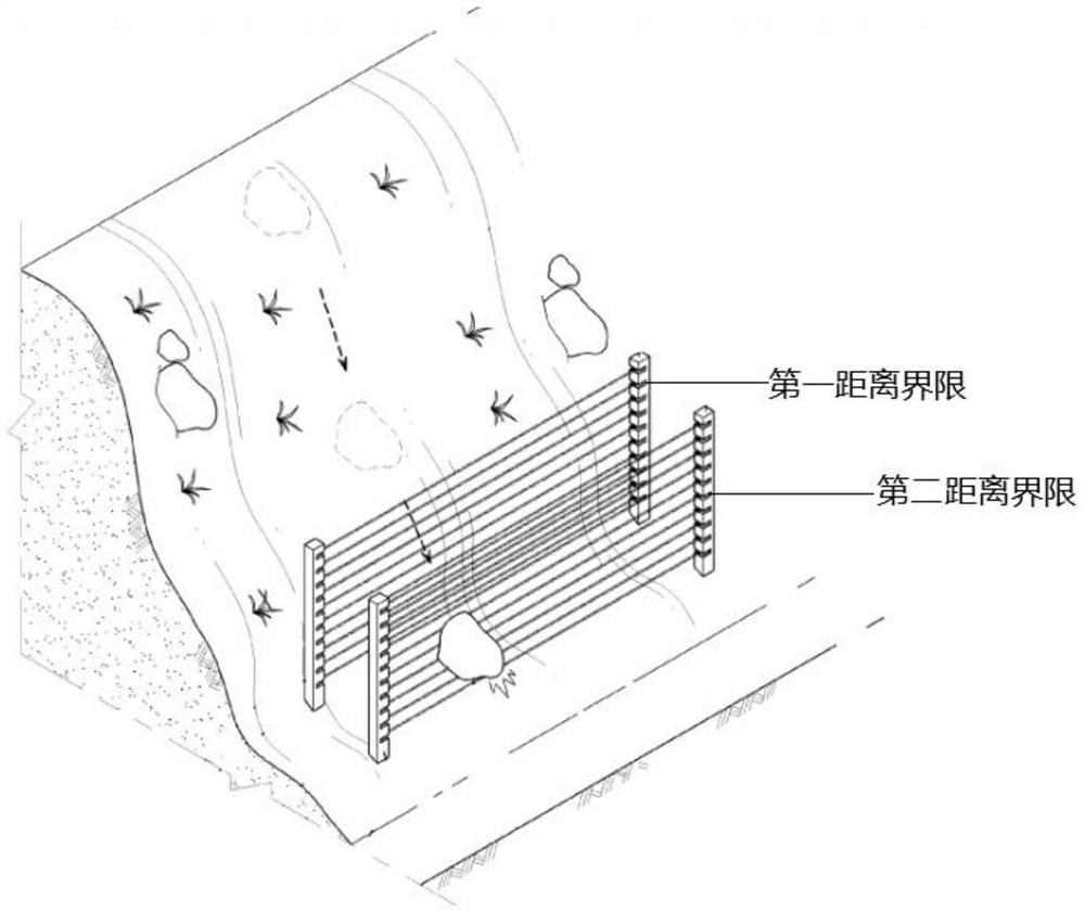
[0040] On the basis of the previous embodiment, the method further includes: setting up two additional image acquisition devices to respectively acquire the image information of the first monitoring area and the second monitoring area of ​​the distant scene; The image information in the second monitoring area is image denoised to reduce the noise interference caused by environmental factors and unmanned vehicles in the image information; the image information after denoising in the first monitoring area and the second monitoring area of ​​the distant view is identified, and the Judging whether there is a rockfall, and obtaining the size of the rockfall and the falling speed of the rockfall; according to the obtained size of the rockfall and the falling speed of the rockfall, delineate the first distance limit and the second distance limit after the falling rockfall is completed; the first The distance limit is at least the limit position that will be reached after the fall of t...

Embodiment 3

[0042] On the basis of the previous embodiment, the method further includes: performing camera calibration on the image acquisition device before acquiring image information through the pre-image acquisition device.

[0043] Specifically, in the image measurement process and machine vision applications, in order to determine the relationship between the three-dimensional geometric position of a point on the surface of a space object and its corresponding point in the image, it is necessary to establish a geometric model of camera imaging. These geometric model parameters are the camera parameter. Under most conditions, these parameters must be obtained through experiments and calculations. This process of solving parameters is called camera calibration (or camera calibration). Whether it is in image measurement or machine vision applications, the calibration of camera parameters is a very critical link. The accuracy of the calibration results and the stability of the algorithm...


PUM


Abstract

The invention belongs to the field of unmanned driving technology, and in particular relates to a method and device for unmanned vehicles to detect the occurrence of rockfall on the side. The data includes: driving speed and driving angular velocity; at the same time, enter the road width during the driving process of the unmanned vehicle, and the body width of the unmanned vehicle; Step 2: Based on the operating data, road width and body width, delineate the safety zone and the body Two monitoring areas on both sides; the safety area is the safety area in the process of the vehicle moving forward; the two monitoring areas are respectively the first monitoring area located on the right side of the vehicle body and the second monitoring area located on the left side of the vehicle body. It has the advantages of high intelligence, high security and high accuracy.

Description

technical field [0001] The invention belongs to the technical field of unmanned driving, and in particular relates to a method and a device for unmanned vehicles to detect side rockfalls. Background technique [0002] Self-driving cars, also known as driverless cars and computer-driven cars, are unmanned ground vehicles that transport power. As autonomous vehicles, self-driving cars can sense their environment and navigate without human intervention. Fully self-driving cars have not yet been fully commercialized. Most of them are prototypes and display systems. Some reliable technologies have only been transferred to mass-produced models and gradually become a reality. [0003] Self-driving cars sense their environment with technologies such as radar, lidar, GPS and computer vision. Advanced control systems translate sensory data into appropriate navigation paths, obstacles and associated signs. By definition, a self-driving car can update its map information through sens...

Claims


Application Information

Patent Timeline
Patent Type & Authority Patents(China)
IPC IPC(8): G06V20/56G06V10/30G06V10/774G06V10/762G06V10/82G06K9/62G06N3/04G01B11/00G01P3/38
CPCG06N3/04G01P3/38G01B11/00G06V20/56G06V10/30G06F18/23G06F18/214
Inventor 胡心怡杨扬
Owner SHANGHAI BOONRAY INTELLIGENT TECH CO LTD
Why Eureka
Try Eureka