Supercharge Your Innovation With Domain-Expert AI Agents!

Construction method of three-dimensional high-precision map based on vehicle-mounted point cloud data

A technology of point cloud data and construction method, applied in the field of three-dimensional high-precision map construction, can solve problems such as inability to update in time, and achieve the effects of reducing labor costs, collecting high-precision information, and improving data collection efficiency

Active Publication Date: 2021-05-25
速度科技股份有限公司
View PDF7 Cites 0 Cited by
  • Summary
  • Abstract
  • Description
  • Claims
  • Application Information

AI Technical Summary

Problems solved by technology

However, in this technical solution, it is necessary to obtain the current and scheduled route of the automatic driving d

Method used


Image

  • Construction method of three-dimensional high-precision map based on vehicle-mounted point cloud data
  • Construction method of three-dimensional high-precision map based on vehicle-mounted point cloud data

Examples


Embodiment

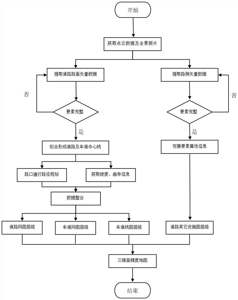
[0038] Example: such as figure 1 As shown, the construction method of the three-dimensional high-precision map based on vehicle-mounted point cloud data specifically includes the following steps:

[0039] S1: collect road point cloud data and panoramic photo data; in the step S1, collect road cloud data and panoramic photo data through a vehicle-mounted laser point cloud collection vehicle; vehicle-mounted laser point cloud collection vehicle performs road point cloud data and panoramic high-definition photos The automatic collection of roads has obtained high-precision point cloud data and high-definition panoramic photo data, realizing efficient, high-speed, and high-precision information collection of road geometry, improving data collection efficiency and reducing labor costs;

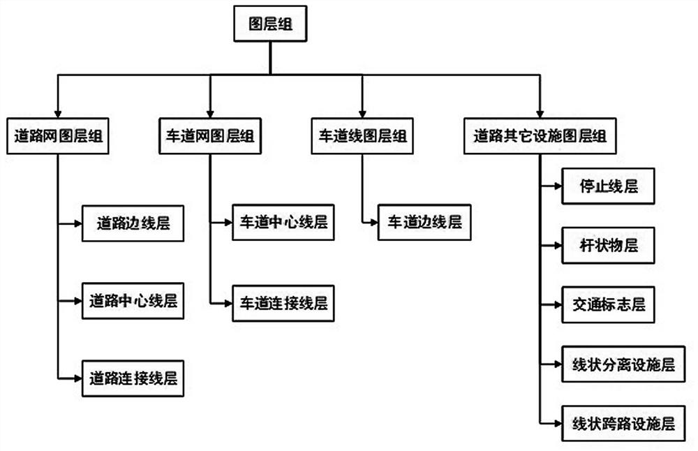
[0040] S2: extracting road vector data from the point cloud data and panoramic photo data obtained in step S1; the road vector data extracted in the step S2 includes road surface vector data and ro...


PUM


Abstract

The invention discloses a construction method of a three-dimensional high-precision map based on vehicle-mounted point cloud data. The method comprises the following steps: S1, collecting point cloud data and panoramic photo data of a road; S2, extracting road vector data from the point cloud data and the panoramic photo data; S3, judging whether element data in the road vector data is complete or not, if the element data is incomplete, returning to the step S2, and if the element data is complete, carrying out analysis processing; S4, performing fitting according to element data in the road vector data to form a road center line and a lane center line, performing topological geometric path planning on the road intersection based on the traffic sign guidance information then, and carrying out gradient analysis and curvature analysis through the road center line and the lane center line to obtain gradient and curvature information; and S5, carrying out data integration on the gradient and curvature information and the element data, forming layer groups of different grades, and associating the element grades of each layer group, so as to obtain a three-dimensional high-precision map.

Description

technical field [0001] The invention relates to the technical field of high-precision maps and unmanned control, in particular to a method for constructing a three-dimensional high-precision map based on vehicle-mounted point cloud data. Background technique [0002] Autonomous driving is the development trend of smart transportation in the future. Traditional navigation electronic maps can no longer meet the needs of autonomous driving. High-precision maps are the key infrastructure for automotive autonomous driving, so they are also called autonomous driving maps. Based on laser point cloud technology High-precision navigation maps can provide centimeter-level road network information through scanning, analysis, processing, and 3D reconstruction of the real environment, and accurately display scenes with dense traffic elements such as lane-level, complex intersections, and viaducts, providing a powerful infrastructure for autonomous driving Assure. [0003] At present, ma...

Claims


Application Information

Patent Timeline
IPC IPC(8): G06T17/05
CPCG06T17/05G06T2200/08
Inventor 朱必亮李俊郭果成
Owner 速度科技股份有限公司
Features
  • R&D
  • Intellectual Property
  • Life Sciences
  • Materials
  • Tech Scout
  • Unparalleled Data Quality
  • Higher Quality Content
  • 60% Fewer Hallucinations
Learn More