BIM three-dimensional geological modeling method based on two-dimensional profile and CATIA

A technology of 3D geology and modeling methods, applied in the field of geological modeling, can solve the problems of low modeling efficiency, low degree of refinement, incompatibility of model formats, etc., and achieve strong compatibility, high degree of precision, and three-dimensional geological intuitive effect

Active Publication Date: 2021-08-17
YUNNAN AEROSPACE ENG GEOPHYSICAL SURVEY INSPECTION
View PDF3 Cites 1 Cited by
  • Summary
  • Abstract
  • Description
  • Claims
  • Application Information

AI Technical Summary

Problems solved by technology

[0003] At present, most of the 3D models in tunnel BIM technology only contain the tunnel structure model, and the displayed content is less. In addition, the visualization degree of the current 3D geological model is relatively low
Traditional geological modeling software can only build models through borehole interpolation, the modeling efficiency is low, and the degree of refinement is relatively low, and the output model format is not compatible with cesium or threejs 3D engines

Method used


Image

  • BIM three-dimensional geological modeling method based on two-dimensional profile and CATIA
  • BIM three-dimensional geological modeling method based on two-dimensional profile and CATIA
  • BIM three-dimensional geological modeling method based on two-dimensional profile and CATIA

Examples


Embodiment 1

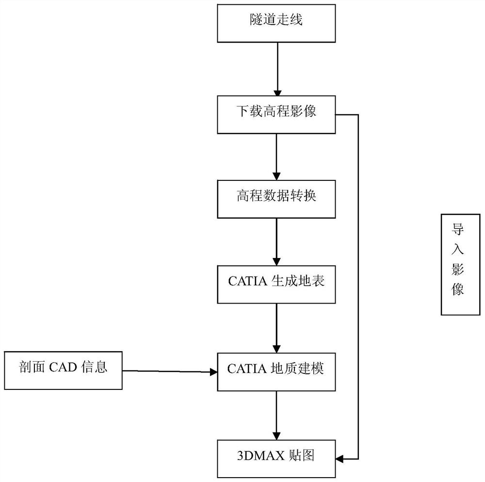
[0058] Such as figure 1 As shown, the present invention will develop the technical route, and the geological body takes the Daliangshan Tunnel Project as the project background, and specifically introduces the three-dimensional geological modeling method.

[0059] Step 1: Download the surface elevation image:

[0060] Such as image 3 As shown, import the kml file of the tunnel location into LocaSpaceViewer, take the entrance and exit of the tunnel as the starting point, select a square area along the tunnel line as the tunnel area, and download the surface elevation image map of the selected tunnel area; among them, the surface elevation The images are tif images.

[0061] Among them: kml file refers to: Keyhole Markup Language, Keyhole markup language, is a markup language based on XML, using XML syntax format to describe geospatial data, including points, lines, polygons, polygons and models.

[0062] LocaSpaceViewer: It is a 3D digital earth product. LocaSpace Viewer pr...

Embodiment 2

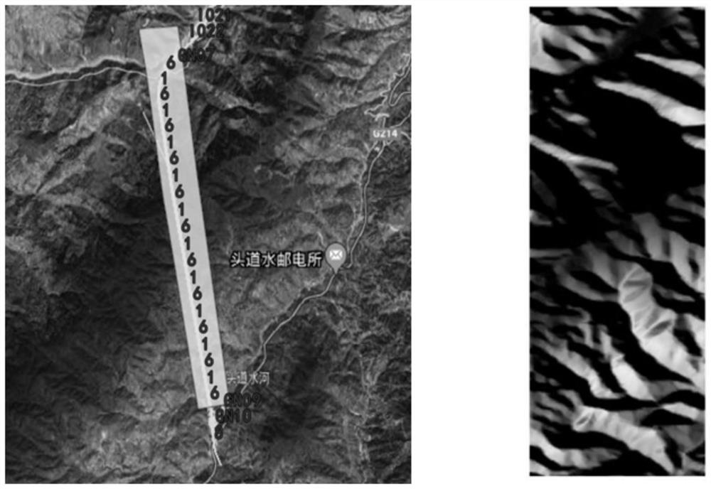
[0087] Step 1: Download surface elevation and satellite images

[0088] Import the kml files of the left and right sides of the tunnel into LocaSpaceViewer, and download the surface elevation and satellite image data of the selected area.

[0089] Step 2: Image elevation data processing

[0090] Import the elevation data into Globalmapper, and export the required xyz elevation data after projection conversion.

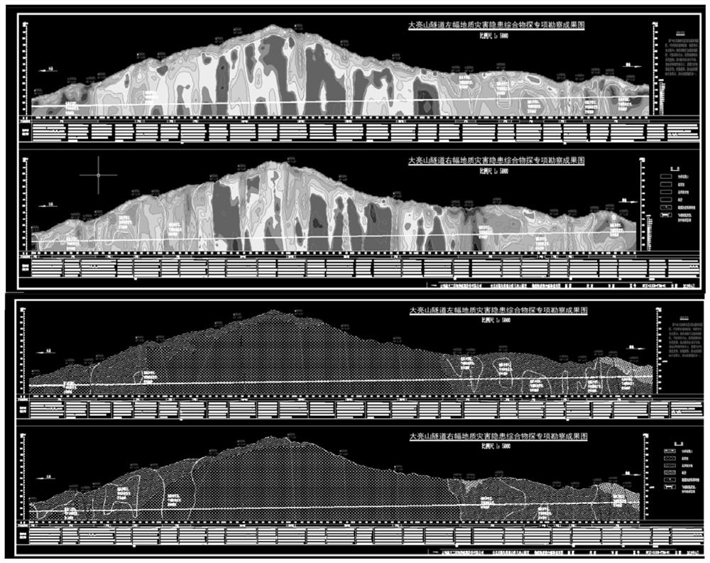
[0091] Step 3: Cross-section geophysical information processing

[0092] In CAD, the geophysical prospecting information is separated from the cross-section information, and the cross-section map and the geophysical low-resistance area map are respectively placed, and two dxf files are generated, corresponding to the left and right panels respectively.

[0093] Step 4: CATIA 3D geological modeling

[0094] The exported dxf file is imported into CATIA, the geological section and ground surface modeling are carried out in the generative shape design module, and the tu...


PUM


Abstract

The invention provides a BIM three-dimensional geologic modeling method based on a two-dimensional profile and CATIA. The method comprises the following steps: downloading a surface elevation image map of a geologic body; converting the surface elevation image map; performing geologic body section geophysical prospecting information processing; carrying out CATIA three-dimensional geological modeling; and carrying out 3DMAX mapping. The method has the following advantages that drilling data is not needed, the three-dimensional geologic body is established only through the two-dimensional cad section and the tunnel position, the characteristics of high precision degree and high compatibility of industrial software are utilized, the industrial software is applied to the geologic field, so that a geologic model is finer, the characteristic of high visualization of animation software is also utilized, the three-dimensional geologic body is more visual, and therefore, a new thought is provided for construction of the tunnel BIM system.

Description

technical field [0001] The invention belongs to the technical field of geological modeling, in particular to a BIM three-dimensional geological modeling method based on two-dimensional sections and CATIA. Background technique [0002] In recent years, BIM technology has continuously developed and matured, and 3D architectural models have also been continuously developed and improved in engineering construction. With the development of front-end technology and industrial modeling software, human beings have higher requirements for 3D models in engineering construction. The degree of visualization is also continuously improved. [0003] At present, most of the 3D models in tunnel BIM technology only contain the tunnel structure model, which shows less content. In addition, the visualization of 3D geological models is relatively low. Traditional geological modeling software can only build models through borehole interpolation, which has low modeling efficiency and a relatively...

Claims


Application Information

Patent Timeline
Patent Type & Authority Applications(China)
IPC IPC(8): G06T17/05G06F30/10
CPCG06T17/05G06F30/10
Inventor 张帅武强曾健苏建坤谭左平徐胚栋
Owner YUNNAN AEROSPACE ENG GEOPHYSICAL SURVEY INSPECTION
Why Eureka
Try Eureka