A Binary Change Detection Method for Remote Sensing Imagery Based on Feature Deviation Alignment

A remote sensing image and change detection technology, applied in the field of remote sensing image processing, can solve the problem of not considering feature deviation, false detection, bi-temporal image feature deviation, etc., to improve the accuracy of change detection, improve detection accuracy, and overcome the ineffectiveness of fusion. Effect

Active Publication Date: 2022-04-29
WUHAN UNIV +1
View PDF0 Cites 0 Cited by
  • Summary
  • Abstract
  • Description
  • Claims
  • Application Information

AI Technical Summary

Problems solved by technology

[0004] However, when the binary change detection method based on Siamese convolutional neural network obtains difference features in high-dimensional feature space, it needs to ensure that the extracted high-dimensional features are aligned in the original bitemporal image as much as possible, otherwise it will be due to The problem of feature deviation appears false detection area
However, due to the existence of registration errors and downsampling layers, there will inevitably be a problem of feature deviation between the high-dimensional features of bitemporal images.
The existing binary change detection methods often directly introduce the semantic segmentation model or make certain improvements on the basis of the semantic segmentation model, without considering the problem of feature deviation

Method used


Image

  • A Binary Change Detection Method for Remote Sensing Imagery Based on Feature Deviation Alignment
  • A Binary Change Detection Method for Remote Sensing Imagery Based on Feature Deviation Alignment
  • A Binary Change Detection Method for Remote Sensing Imagery Based on Feature Deviation Alignment

Examples


Embodiment Construction

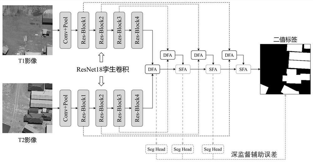
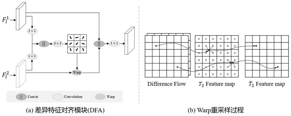
[0051] In order to make the technical method of the present invention clearer, the specific implementation of the present invention will be described in further detail below in conjunction with the accompanying drawings, but the specific examples described are only to illustrate the spirit of the present invention, and the implementation is not limited thereto.

[0052] Step 1. Construct a dual-temporal remote sensing image change detection dataset and perform preprocessing.

[0053] Specifically, step 1 further includes:

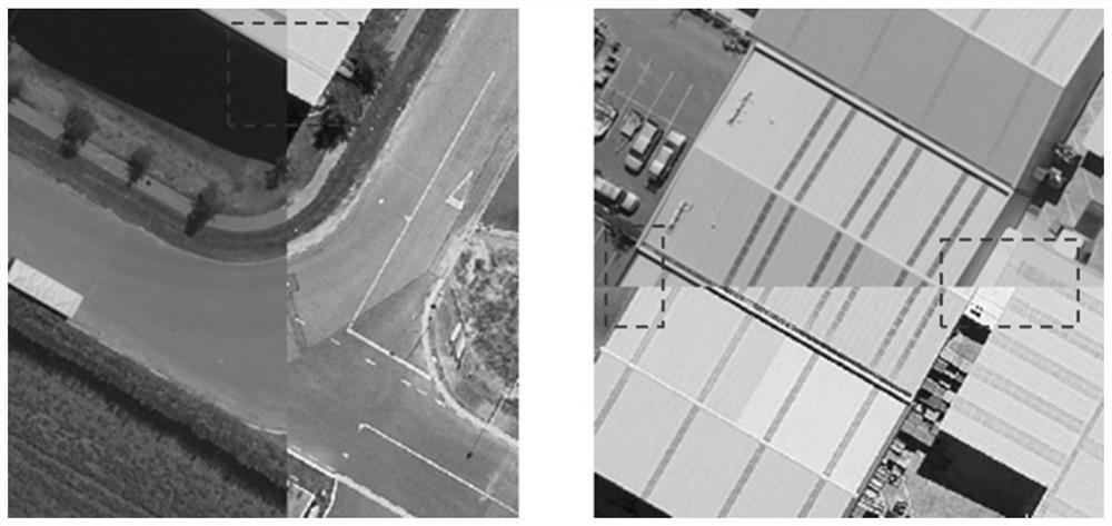
[0054] Step 1.1, the present invention selects the open source WHU Building building change detection data set of the network to construct a dual-temporal remote sensing image change detection data set, which includes two dual-temporal remote sensing images, which were taken in 2012 and 2016 respectively, and the image size is 15354×32057, with a resolution of 0.3 meters, covering an area of ​​20 square kilometers. Since the original image is a large-scale...


PUM


Abstract

The invention discloses a binary change detection method of remote sensing images based on feature deviation alignment, comprising: step 1: constructing a dual-temporal remote sensing image binary change detection data set and performing preprocessing; step 2: constructing a binary change detection method based on feature deviation alignment Binary change detection model, and given the bitemporal remote sensing image to obtain the change area prediction result and the auxiliary prediction map of the change area; step 3: use the real change area label results and the predicted change area results and the change area auxiliary prediction map to calculate the main loss respectively Function and auxiliary loss function, update the model by backpropagating the gradient according to the loss, stop the training until the loss value converges, save the model structure and model weight; step 4: use the model weight trained in step 3 to predict the test set data. The invention can effectively solve the misdetection phenomenon of changing regions caused by factors such as multi-angle shooting, too many high-rise buildings, or large terrain fluctuations in dual-temporal remote sensing images.

Description

[0001] field of invention [0002] The invention belongs to the field of remote sensing image processing, relates to the field of computer deep learning, and in particular relates to a binary change detection method of remote sensing images based on feature deviation alignment. Background technique [0003] The goal of the binary change detection task is to locate the change area and non-change area of ​​the area given two dual-temporal remote sensing images of the same area. With the development of deep learning technology, methods based on twin convolutional neural networks have achieved higher accuracy than traditional methods in binary change detection tasks, which usually use an encoder-decoder architecture, that is, twin convolutional neural networks with shared weights are first used. The network encoder extracts the low-level features and high-level features of the bitemporal image respectively, and then uses the decoder to obtain the difference features and gradually ...

Claims


Application Information

Patent Timeline
Patent Type & Authority Patents(China)
IPC IPC(8): G06V20/10G06V10/80G06V10/77G06V10/28G06V10/82G06N3/04G06N3/08G06T7/33
CPCG06N3/084G06T7/33G06T2207/10032G06T2207/20081G06T2207/20084G06T2207/20132G06N3/045G06F18/213G06F18/253
Inventor 乐鹏黄立张晨晓梁哲恒姜福泉魏汝兰章小明
Owner WUHAN UNIV
Why Eureka
Try Eureka