A method for identifying overwintering crop planting area based on multi-source full-time satellite images under a cloud computing platform

A cloud computing platform and satellite image technology, applied in the field of remote sensing target recognition, can solve the problems of insufficient data volume, difficulty in accurately capturing the phenological dynamics of overwintering crops, and incomplete phenological information, so as to reduce the impact.

Active Publication Date: 2022-02-01
HENAN UNIVERSITY
View PDF6 Cites 0 Cited by
  • Summary
  • Abstract
  • Description
  • Claims
  • Application Information

AI Technical Summary

Problems solved by technology

[0003] Aiming at the problem that the identification of overwintering crop planting area in the past is usually based on multi-temporal NDVI values, and it is difficult to accurately capture the phenological dynamics of overwintering crops in areas with harsh weather and cloudy coverage, the present invention proposes a cloud computing platform based on multi-source full-time The overwintering crop planting area identification method based on satellite imagery greatly increases the number of high-quality images available on each pixel by fusing all multi-sensor satellite images, and solves the problem caused by insufficient single-sensor, single-temporal and multi-temporal image data. The problem of incomplete phenological information; the cultivated land mask is obtained by classifying land cover, which reduces the impact of other land cover types on the extraction of overwintering crops; the unique growth characteristics of crops are obtained by analyzing the phenological characteristics of the complete growth cycle of overwintering crops, More comprehensive and accurate than the multi-temporal extraction method

Method used


Image

  • A method for identifying overwintering crop planting area based on multi-source full-time satellite images under a cloud computing platform
  • A method for identifying overwintering crop planting area based on multi-source full-time satellite images under a cloud computing platform
  • A method for identifying overwintering crop planting area based on multi-source full-time satellite images under a cloud computing platform

Examples


Embodiment Construction

[0027] The present invention will be further explained below in conjunction with accompanying drawing and specific embodiment:

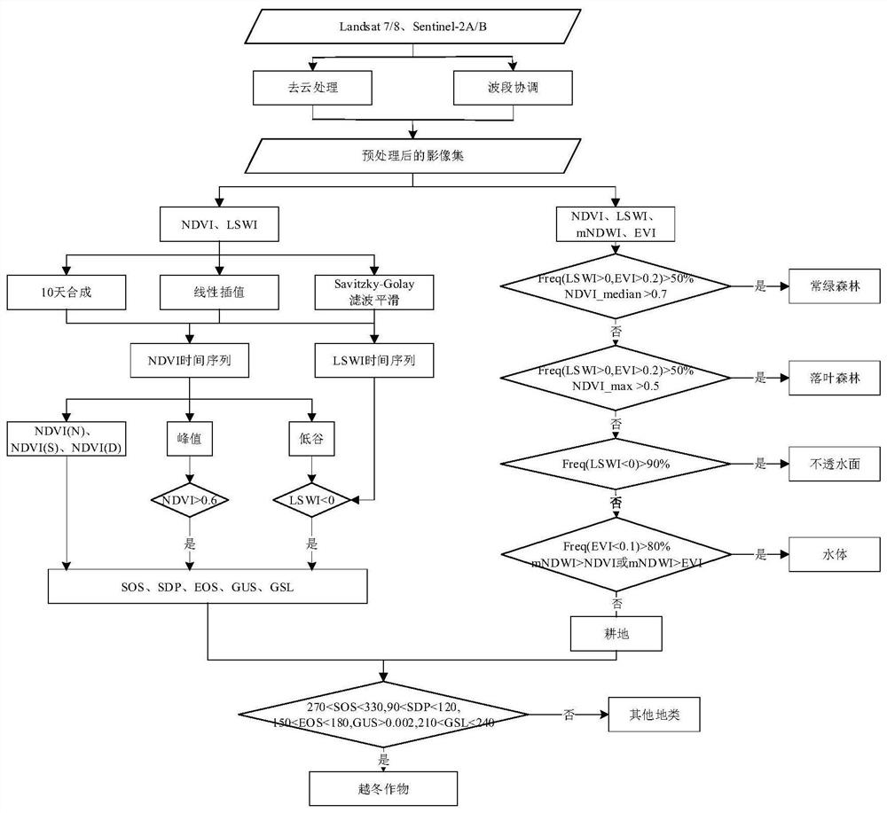
[0028] Such as figure 1 As shown, the embodiment of the present invention provides a method for identifying planting area of ​​overwintering crops based on multi-source full-time satellite images under a cloud computing platform, and the specific steps are as follows:

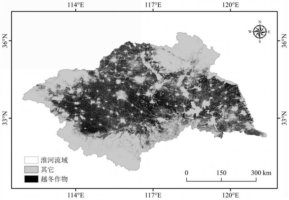
[0029] S1. Obtain all available Landsat 7 ETM+, Landsat 8 OLI and Sentinel-2A / B MSI satellite images in the study area based on the cloud computing platform; as an implementable method, based on the GEE (Google Earth Engine) cloud computing platform , using JavaScript programming to obtain the total number of pixel-by-pixel Landsat 7 ETM+, Landsat 8 OLI and Sentinel-2A / B MSI satellite images of the Huaihe River Basin from September 1, 2017 to June 30, 2018.

[0030] S2. Perform preprocessing on the satellite image described in step S1, including: cloud removal processing and band coo...


PUM


Abstract

The invention discloses a method for identifying planting area of ​​overwintering crops based on multi-source full-time satellite images under a cloud computing platform. First, the Landsat 7 / 8 and Sentinel‑2A / B satellite images are fused and preprocessed to calculate NDVI, LSWI, EVI and mNDWI classify the land cover to obtain the cultivated land mask, use the 10-day image synthesis method, linear interpolation and Savitzky‑Golay filter to reconstruct the time series; secondly, iterate on the reconstructed time series data set Algorithm, identify the peaks and troughs in the time series curve, use the threshold method to determine the start date and end date of the growing season of overwintering crops, calculate the growth rate of the maximum growth period and the span of the complete growth cycle; finally, according to the phenology of overwintering crops in different phenological periods Indicator, set the threshold to extract the acreage of overwintering crops on the pixel scale. The invention realizes precise remote sensing and automatic identification of planting area of ​​overwintering crops.

Description

technical field [0001] The invention belongs to the technical field of remote sensing target recognition, and in particular relates to a method for recognizing planting area of ​​overwintering crops based on multi-source full-time satellite images under a cloud computing platform. Background technique [0002] Usually, methods of obtaining crop planting information include agricultural census method and remote sensing extraction method. Timeliness is a major factor in agricultural statistics and related monitoring systems, and the traditional agricultural census method is not time-sensitive. Official cultivated land statistics contain a lot of information about the distribution of crop types, but the statistics of the total cultivated land area are based on the administrative region and cannot be specific to the spatial distribution within the administrative region. The accuracy of the area information depends on the reporting and sample size of the grassroots. The use of r...

Claims


Application Information

Patent Timeline
Patent Type & Authority Patents(China)
IPC IPC(8): G06V20/10G06K9/00G06V10/30G06V10/764G06K9/62G06T7/62
CPCG06T7/62G06T2207/10036G06F2218/14G06F2218/04G06F2218/10G06F18/2431
Inventor 夏浩铭潘力卢鹤立秦耀辰
Owner HENAN UNIVERSITY
Why Eureka
Try Eureka