Method and device for determining accuracy of calibration results among multiple laser radars

A laser radar and accuracy technology, applied in the field of sensors, can solve problems such as inability to understand the accuracy of calibration results conveniently and accurately, and point cloud data cannot be well integrated, and achieve the effect of reducing the amount of calculation

Pending Publication Date: 2021-10-12
BEIJING JINGDONG QIANSHITECHNOLOGY CO LTD
View PDF8 Cites 0 Cited by
  • Summary
  • Abstract
  • Description
  • Claims
  • Application Information

AI Technical Summary

Problems solved by technology

[0004] In the process of realizing the present invention, the inventors found that there are at least the following problems in the prior art: the existing calibration processing methods and devices cannot conveniently and accurately understand the accuracy of the calibration results after the calibration is completed, and if the calibration results are not accurate, It may happen that even if the point cloud data obtained by multiple lidars is converted using the calibration result, the point cloud data cannot be well integrated

Method used


Image

  • Method and device for determining accuracy of calibration results among multiple laser radars
  • Method and device for determining accuracy of calibration results among multiple laser radars
  • Method and device for determining accuracy of calibration results among multiple laser radars

Examples


no. 1 approach

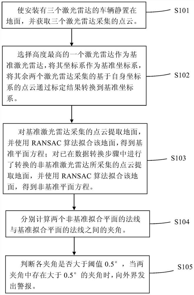
[0048] The method for determining the accuracy of calibration results among multiple laser radars according to an embodiment of the present invention is used to determine the accuracy of calibration results among multiple vehicle-mounted multi-line laser radars.

[0049] figure 1 Represents a method for determining the accuracy of calibration results between multiple laser radars according to an embodiment of the present invention, such as figure 1 As shown, the method for determining the accuracy of the calibration results among multiple laser radars according to an embodiment of the present invention achieves the effect of expressing the accuracy of the calibration results simply and intuitively with numerical values.

[0050] exist figure 1 The illustrated method for determining the accuracy of the calibration results between multiple laser radars according to an embodiment of the present invention includes a data acquisition step S101, where a vehicle equipped with multip...

Deformed example 1

[0078] According to the fitting plane fitted by point cloud data in a single frame, there will be great errors in judging the quality of the calibration results, and it is easily affected by unexpected situations, resulting in errors in the accuracy of the determined calibration results, etc. .

[0079] As an improvement of the first embodiment of the present invention, in the data acquisition step, multiple frames of point cloud data collected by multiple laser radars are obtained, and a fitting plane is obtained by the same laser radar according to each frame of point cloud data. That is, each lidar fit has multiple (the amount corresponding to the number of frames) fitting planes.

[0080] Since there are multiple fitting planes according to the point cloud data obtained by each lidar, the content in each frame will be compared between the normal of the two non-reference fitting planes and the normal of the reference fitting plane. Between the lines, two angles are formed....

no. 2 approach

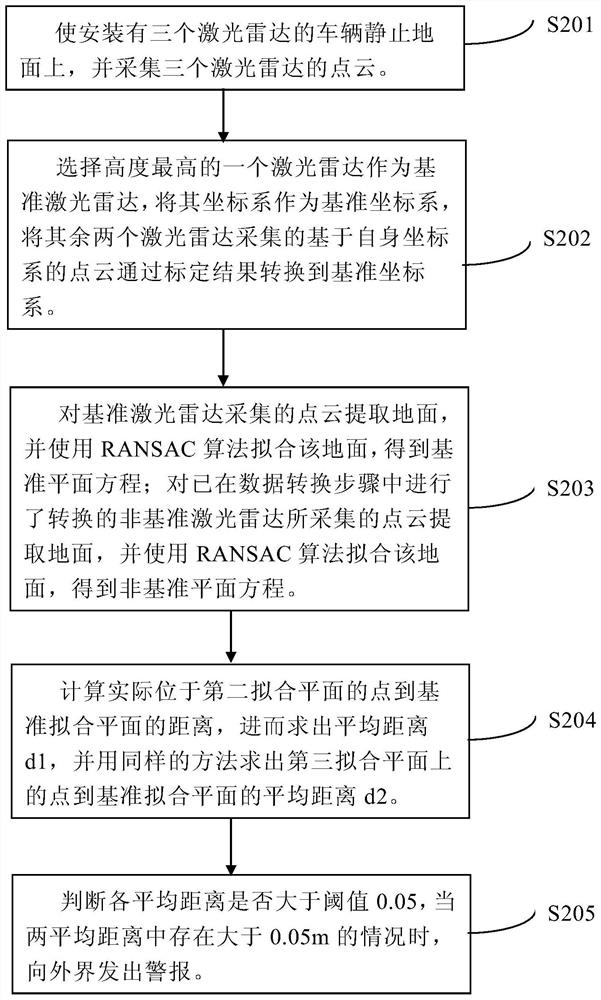
[0084] The difference between the second embodiment of the present invention and the above-mentioned first embodiment is that in the calculation step S204, the point in the non-reference plane in the point cloud data obtained by the non-reference lidar is calculated using the distance formula from the point to the plane The distance to the datum fitting plane, and then find the average distance of these distances. The size of the average distance represents the difference between the non-reference fitting plane and the reference fitting plane, so the average distance is used to represent the accuracy of the calibration result. The other steps (data acquisition step S201, data conversion step S202, and fitting step S203) are the same as those in the first embodiment, so descriptions thereof are omitted.

[0085] In the calculation step of this embodiment, in the calculation step S204, the points actually located on the second fitting plane (A2X+B2Y+C2Z+D2=0) are calculated resp...


PUM


Abstract

The invention discloses a method and device for determining the accuracy of calibration results among multiple laser radars, and relates to the field of sensors. A specific embodiment of the method comprises the following steps of acquiring the point cloud data acquired by the plurality of laser radars for a scene including a flat surface; converting the point cloud data acquired by the plurality of laser radars into a same coordinate system by using a calibration result; fitting the equations representing the flat surface based on the point cloud data of each laser radar; and calculating a numerical value characterizing the accuracy of the calibration result by using the plurality of equations. According to the embodiment, the effect of simply and intuitively representing the accuracy of the calibration result by using the numerical value is realized.

Description

technical field [0001] The invention relates to the field of sensors, in particular to a method and a device for determining the accuracy of calibration results among multiple laser radars. Background technique [0002] In recent years, in the fields of transportation, national defense and security, the application of laser radar has become more and more extensive. For example, in the prior art, a laser radar is installed on a car and the laser radar is used to obtain external information to assist the driver in driving, or to perform automatic driving. [0003] Due to the occlusion of the vehicle itself and the blind spots of the lidar, a single lidar sensor usually cannot complete the task, and multiple lidars need to be installed on the car to compensate for each other's blind spots. The coordinate relationship between different lidars is the key to fusing the point cloud data of multiple lidars together. There are many calibration methods. The so-called calibration ref...

Claims


Application Information

Patent Timeline
Patent Type & Authority Applications(China)
IPC IPC(8): G01S7/497
CPCG01S7/497
Inventor 阚常凯许新玉
Owner BEIJING JINGDONG QIANSHITECHNOLOGY CO LTD
Why Eureka
Try Eureka