Multi-measurement-in-one data acquisition and database building method for engineering construction project

A construction project and data acquisition technology, applied in the field of surveying and mapping geographic information, can solve problems such as unintuitive workload, less information, and non-traceability, and achieve the effect of uniqueness, efficiency and accuracy

Active Publication Date: 2021-10-19
JIANGSU PROVINCE SURVEYING & MAPPING ENG INST
View PDF5 Cites 3 Cited by
  • Summary
  • Abstract
  • Description
  • Claims
  • Application Information

AI Technical Summary

Problems solved by technology

The existing "multi-measurement in one" technical solution has limitations: ①Measuring equipment is mainly traditional single-point measuring instruments such as GNSS receivers, total stations, range finders, etc., with low collection efficiency, less information, and no traceability ; For example, at present, instruments such as total stations and GNSS receivers are mainly used for multi-measurement and one-in-one data collection, which has low efficiency, less information, and is not traceable
There is also a method of using static 3D laser scanning technology on the ground to assist "multi-measurement in one", but there are blind spots on the top of the building, and there are too many stations in the green area
② The planning verification survey, real estate survey, cadastral survey and other results are stored independently. Different survey services repeatedly collect the same ground features and store them separately in the database. It is inevitable that there will be duplication, conflict, and redundancy in the spatial information of the ground features. , which is not conducive to the management of achievement data and the dynamic maintenance of the database
③The results of the "multi-inspection integration" of the existing scheme are not ideal for the support effect of the "multi-inspection integration". This makes the traditional acceptance method generally use single-point measuring instruments such as total stations and GNSS receivers to collect index data, and then perform two-dimensional comparison with drawings, which is not intuitive and requires a lot of work.

Method used


Image

  • Multi-measurement-in-one data acquisition and database building method for engineering construction project

Examples


specific Embodiment 1

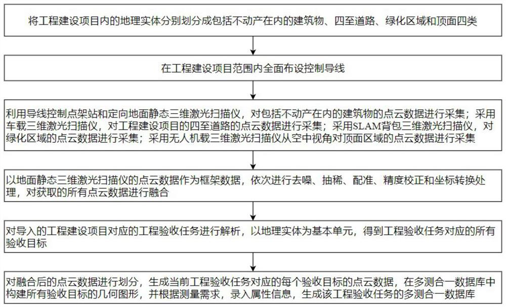
[0062] figure 1 It is a flow chart of the multi-measurement-in-one data collection and database building method of the engineering construction project in this embodiment. see figure 1 , the multi-measurement-in-one database generation method is used to generate and store the current status information of the geographic entities of the engineering construction project, including:

[0063] S1, the geographical entities in the engineering construction project are divided into four categories: buildings including real estate, four roads, green areas and top surfaces.

[0064] The "multi-measurement-in-one" database of this embodiment breaks the existing database structure defined separately by measurement business, integrates the elements of the original planning verification measurement, real estate measurement, and cadastral measurement, and re-divides them into various geographical Entities, such as engineering construction project geographic entities, real estate geographic...

specific Embodiment 2

[0117] This embodiment mentions a method for implementing multi-inspection integration based on geographic entities. The multi-inspection integration method includes:

[0118] Use the plan, elevation, and section drawings of the engineering design building, as well as the special drawings of fire protection, HVAC, water supply and drainage pipelines, to construct the corresponding building information model of the engineering design building, and fully express the situation of planning and design in three dimensions.

[0119] Using the method mentioned above to generate a multi-measurement database corresponding to the project acceptance task, comprehensively express the current situation of the construction in three dimensions.

[0120] The multi-inspection database and the building information model are combined and compared, and the building structure and construction accuracy are comprehensively inspected on the three-dimensional scale, so as to realize the multi-inspection...


PUM


Abstract

The invention discloses a multi-measurement-in-one data acquisition and database building method for an engineering construction project. The method comprises the steps of carrying a three-dimensional laser scanner, a camera and other sensors through a ground tripod, a mobile measurement vehicle, an unmanned plane, an SLAM backpack and other multiple platforms, and carrying out the multi-measurement-in-one total-factor acquisition; integrating measurement results and inputting into a 'multi-measurement-in-one' database based on a full-life-cycle geographic entity, and realizing 'multi-verification-in-one' of planning verification, cadastre and real estate through comparison of point cloud and BIM. The method has the advantages of being high in collection efficiency, complete in measurement information, traceable in result, capable of supporting three-dimensional integrated acceptance and the like, and has method demonstration and technical guidance significance for comprehensively promoting in-place 'multi-measurement-in-one' implementation.

Description

technical field [0001] The invention relates to the technical field of surveying and mapping geographic information technology, in particular to a multi-measurement-in-one data collection and database building method for an engineering construction project. Background technique [0002] "Multi-measurement in one" measurement items include the most basic planning verification measurement, real estate measurement, cadastral measurement, and civil air defense measurement, green space measurement, fire protection measurement, etc. can also be added. There are limitations in the existing "multi-measurement-in-one" technical solution: ①Measuring equipment is mainly traditional single-point measuring instruments such as GNSS receivers, total stations, and rangefinders, which have low collection efficiency, less information, and no traceability ; For example, at present, instruments such as total stations and GNSS receivers are mainly used for multi-measurement and one-in-one data c...

Claims


Application Information

Patent Timeline
Patent Type & Authority Applications(China)
IPC IPC(8): G01C15/00G01B11/24G01C21/16
CPCG01C15/002G01B11/24G01C21/165
Inventor 陈勇赵小祥黄亮
Owner JIANGSU PROVINCE SURVEYING & MAPPING ENG INST
Why Eureka
Try Eureka