Land resource analysis model training method and analysis method based on image recognition
A land resource and image recognition technology, applied in the field of land resource analysis model training methods and analysis, can solve problems such as low accuracy, low efficiency, and difficulty in meeting the needs of centralization and scale
- Summary
- Abstract
- Description
- Claims
- Application Information
AI Technical Summary
Problems solved by technology
Method used
Image
Examples
Embodiment Construction
[0075] In order to better understand the purpose, technical solutions and technical effects of the present invention, the present invention will be further explained below with reference to the accompanying drawings and embodiments. At the same time, it is stated that the embodiments described below are only used to explain the present invention, and are not used to limit the present invention.
[0076] The embodiment of the present invention provides a method for training a land resource analysis model based on image recognition.
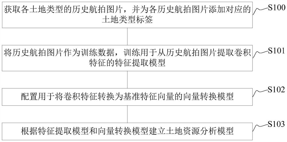
[0077] figure 1 It is a flowchart of the method for training a land resource analysis model based on image recognition in one embodiment, such as figure 1 As shown, an image recognition-based land resource analysis model training method includes steps S100 to S103:
[0078] S100, obtaining historical aerial photographs of each land type, and adding corresponding land type labels to each historical aerial photograph;
[0079] S101, using historic...
PUM
 Abstract
Description
Claims
Application Information
 - R&D
- Intellectual Property
- Life Sciences
- Materials
- Tech Scout
- Unparalleled Data Quality
- Higher Quality Content
- 60% Fewer Hallucinations
Browse by: Latest US Patents, China's latest patents, Technical Efficacy Thesaurus, Application Domain, Technology Topic, Popular Technical Reports.
© 2025 PatSnap. All rights reserved.Legal|Privacy policy|Modern Slavery Act Transparency Statement|Sitemap|About US| Contact US: help@patsnap.com


